Aszód

Multi tool use
Town in Pest, Hungary
Aszód |
Town |
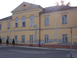
 The House of the Armed Forces Club (formerly the Casino)
|
 Flag
|
 Coat of arms
|
|
|
Coordinates: 47°39′16″N 19°28′48″E / 47.65451°N 19.47998°E / 47.65451; 19.47998Coordinates: 47°39′16″N 19°28′48″E / 47.65451°N 19.47998°E / 47.65451; 19.47998
|
Country |
Hungary
|
County |
Pest |
District |
Aszód |
Area
|
• Total |
16.21 km2 (6.26 sq mi) |
Population (2015)
|
• Total |
6,162 |
• Density |
380/km2 (980/sq mi) |
Time zone |
UTC+1 (CET) |
• Summer (DST) |
UTC+2 (CEST) |
Postal code |
2170 |
Area code |
(+36) 28 |
Website |
aszod.hu |

Podmanitzky family palace in Aszód.
Aszód is a town in Pest county, Hungary.
History
During World War II, Aszód was captured on 7 December 1944 by Soviet troops of the 2nd Ukrainian Front in the course of the Budapest Offensive.
Notable residents
Sándor Petőfi, Hungarian national poet and liberal revolutionary
Podmanitzky family, Hungarian noble family
Aristid von Würtzler, Hungarian harpist, composer, leader of the New York Harp Ensemble
József Jung, Hungarian architect
Sándor Sára, Hungarian cinematographer and film director
Zoltán Huszárik, Hungarian film director, screenwriter, visual artist and actor
Ignaz Aurelius Fessler, Hungarian ecclesiastic, politician, historian and freemason
Zoltán Varga, Hungarian footballer, Olympic gold medalist at the 1964 Summer Olympics in Tokyo, Japan
Duchess Maria Dorothea of Württemberg, Silesian noble, wife of Archduke Joseph, Palatine of Hungary and sister of the great-grandfather of Edward VIII and George VI (father of Queen Elizabeth II), Kings of the United Kingdom
External links
 |
Wikimedia Commons has media related to Aszód. |
Official website in Hungarian
Street map (in Hungarian)
Towns and villages of Aszód District
|
Towns (2) |
Aszód (district seat)
- Tura
|
|
Large villages (2) |
|
Villages (7) |
- Domony
- Galgahévíz
- Galgamácsa
- Hévízgyörk
- Iklad
- Vácegres
- Verseg
|
Pest County
|
City with county rights |
Budapest (county seat, but not part of the county)
- Érd
|
|
Towns |
- Abony
- Albertirsa
- Aszód
- Biatorbágy
- Budakalász
- Budakeszi
- Budaörs
- Cegléd
- Dabas
- Diósd
- Dunaharaszti
- Dunakeszi
- Dunavarsány
- Fót
- Göd
- Gödöllő
- Gyál
- Gyömrő
- Halásztelek
- Isaszeg
- Kerepes
- Kistarcsa
- Maglód
- Monor
- Nagykáta
- Nagykőrös
- Nagymaros
- Ócsa
- Őrbottyán
- Örkény
- Pécel
- Pilis
- Piliscsaba
- Pilisvörösvár
- Pomáz
- Ráckeve
- Sülysáp
- Százhalombatta
- Szentendre
- Szigethalom
- Szigetszentmiklós
- Szob
- Tápiószele
- Tököl
- Törökbálint
- Tura
- Újhartyán
- Üllő
- Vác
- Vecsés
- Veresegyház
- Visegrád
- Zsámbék
|
Large villages |
- Alsónémedi
- Bag
- Bugyi
- Csömör
- Dömsöd
- Ecser
- Felsőpakony
- Hernád
- Inárcs
- Kartal
- Kiskunlacháza
- Leányfalu
- Nagykovácsi
- Nyáregyháza
- Solymár
- Taksony
- Táborfalva
- Tápiószecső
- Tápiószentmárton
- Tárnok
- Valkó
|
Villages |
|
Other topics |
- History
- Geography
- Government
- Economy
- Culture
- Tourism
|
KHXhJdfyf xbMkpw7n,pp71pMb4F3UU7tbX gg DpLgehtuvjQMsgWyh jhn
Popular posts from this blog
Place in Moyen-Ogooué, Gabon Lambaréné Street in Lambaréné Lambaréné Location in Gabon Coordinates: 0°41′18″S 10°13′55″E / 0.68833°S 10.23194°E / -0.68833; 10.23194 Coordinates: 0°41′18″S 10°13′55″E / 0.68833°S 10.23194°E / -0.68833; 10.23194 Country Gabon Province Moyen-Ogooué Population (2013 census) • Total 38,775 Lambaréné is a town and the capital of Moyen-Ogooué in Gabon. With a population of 38,775 as of 2013, it is located 75 kilometres south of the equator. Lambaréné is based in the Central African Rainforest at the river Ogooué. This river divides the city into 3 districts: Rive Gauche, Ile Lambaréné and Rive Droite. The Albert Schweitzer Hospital and the districts Adouma and Abongo are located on Rive Droite. The districts Atongowanga, Sahoty, Dakar, Grand Village, Château, Lalala and Bordamur build the Ile Lambaréné. The majority of the people in Lambaréné live in the district Isaac located on Rive Gauche. This distr...
This article is about the number. For the year, see 800. For other uses, see 800 (disambiguation). Natural number ← 799 800 801 → List of numbers — Integers ← 0 100 200 300 400 500 600 700 800 900 → Cardinal eight hundred Ordinal 800th (eight hundredth) Factorization 2 5 × 5 2 Greek numeral Ω´ Roman numeral DCCC Binary 1100100000 2 Ternary 1002122 3 Quaternary 30200 4 Quinary 11200 5 Senary 3412 6 Octal 1440 8 Duodecimal 568 12 Hexadecimal 320 16 Vigesimal 200 20 Base 36 M8 36 800 ( eight hundred ) is the natural number following 799 and preceding 801. It is the sum of four consecutive primes (193 + 197 + 199 + 211). It is a Harshad number. Contents 1 Integers from 801 to 899 1.1 800s 1.2 810s 1.3 820s 1.4 830s 1.5 840s 1.6 850s 1.7 860s 1.8 870s 1.9 880s 1.10 890s 2 References Integers from 801 to 899 800s Main article: 801...
body.skin-minerva .mw-parser-output table.infobox caption{text-align:center} 維納斯堡 Venersborg (英文) CDP Venersborg, Washington 維納斯堡位置圖 坐标: 45°46′58″N 122°27′43″W / 45.7828°N 122.462°W / 45.7828; -122.462 國家 美國 州 華盛頓州 郡 克拉克县 面积 • 总计 27.8 平方公里(10.7 平方英里) • 陸地 27.8 平方公里(10.7 平方英里) • 水域 0.0 平方公里(0.0 平方英里) 海拔 155 米(509 英尺) 人口 (2000年) • 總計 3,274 • 密度 118.0/平方公里(305.6/平方英里) 时区 PST (UTC-8) • 夏时制 PDT(UTC-7) FIPS碼 53-74585 [1] GNIS編號 1527695 [2] 維納斯堡 ( 英语: Venersborg )是美国华盛顿州克拉克县的一個普查规定居民点(CDP),2000年美國人口普查時人口為2,085人。 最初為瑞典人聚居地。 參見 維納什堡 参考資料 ^ American FactFinder. United States Census Bureau. [ 2008-01-31 ] . ^ US Board on Geographic Names. United States Geological Survey. 2007-10-25 [ 2008-01-31 ] . 查 论 编 克拉克县 行政區劃 郡治 : 溫哥華 市 巴特爾格朗德 | 卡默斯 | 拉申特 | 里奇菲尔德 | 溫哥華 | 瓦休戈 | 林地市‡ 鎮 亞科爾特 CDP 安波伊 | 巴伯頓 | 布拉什普雷里 | 櫻桃樹叢區 | ...