貝里 (法國)
| 本條目需要擴充。 (2013年2月14日) |
| |||||||||||||||||||||||||||


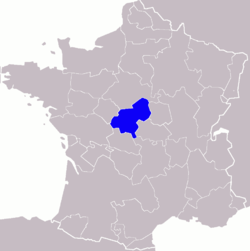

貝里與現代行政區的比較圖。
贝里(法语:Berry),法国旧制下行省,首府是布尔日(Bourges)。
在卡洛林王朝时期贝里是一个独立的伯爵领,其后为阿基坦公爵和安茹公爵及布卢瓦公爵分有。法国的国王们于十一世纪起开始攫取这个省份,在长达两个世纪的时间内将它完全纳入国王领地。
1360年,贝里由国王约翰二世立为公爵领,作为他儿子“贝里的约翰一世”(1340年—1416年)之采邑。贝里公爵领于1434年,在奥弗涅女公爵玛丽一世(1375年—1434年)和她的第三任丈夫波旁公爵让一世(1381年—1434年)死后被重新划归国王领地,而非“正常地”继承给她的子嗣。作为采邑,贝里应当在其受封者的所有男性后代灭绝后还归国王领地,因此玛丽一世理应受到特殊待遇。
贝里公爵领于1498年再次被转让给让娜·德·法兰西(1464年—1505年),路易十一之女。贝里公爵的头衔之后断断续续地转给数个王子,比如查理十世的二儿子。
法国大革命后,贝里在行政上被划分入谢尔省、安德尔省以及卢瓦雷省的最西部分。


