墨西哥高原
| 墨西哥高原 Altiplanicie mexicana | |
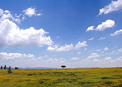 墨西哥高原,靠近瓜納華托州聖米格爾德阿連德處 | |
| 国家 | |
|---|---|
| 省/州/邦 | 契瓦瓦州、科阿韋拉州、杜蘭戈州、薩卡特卡斯州、聖路易斯波托西州、阿瓜斯卡連特斯州、哈利斯科州、薩卡特卡斯州 、瓜納華托州、克雷塔羅州 、墨西哥州、伊達爾戈州 |
| 坐标 | 24°N 103°W / 24°N 103°W / 24; -103 |
| 最高點 | 2,745m(9,000ft)[1] |
| 最低点 | 1,005m(3,300ft)[2] |
| 长度 | 1,532 km(952 mi) |
| 宽度 | 352 km(219 mi) |
| 面积 | 601,882 km²(232,388 mi²) |
| 人口 | 14,800,000(1990 [3]) |
| 人口密度 | 24.58 /km² (64 /mi²) |
 | |
墨西哥高原(西班牙語:Altiplanicie mexicana)是一個佔據了墨西哥中部和北部大部份面積的乾旱半乾旱高原。平均海拔約1,825公尺(5,988英尺),從北部的美墨邊境一直延伸到南部的跨墨西哥火山帶,西部與西馬德雷山脈接壤,東部與東馬德雷山脈接壤。
薩卡特卡斯州一座東西向的低矮山脈將墨西哥高原分成了兩部份,即北部高原(西班牙文:Mesa del Norte)和中部高原(西班牙文:Mesa Central),不過現代地理學家一般只將他們視作一個高原。
墨西哥高原的絕大部份地區都是荒漠和干燥疏灌丛,周圍的山區則是松橡林,而在一些內部山區形成了天空島。墨西哥高原是盆嶺省的六個分區之一,是一種山間高原。
目录
1 地理
2 参考文献
2.1 引用
2.2 来源
地理
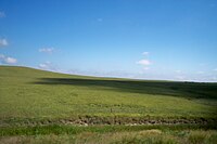
北部高原

南部的墨西哥谷
北部高原平均海拔1,100米(3,600英尺),從南部邊界格蘭德河一直穿過契瓦瓦州、科阿韋拉州、杜蘭戈州、薩卡特卡斯州和聖路易斯波托西州。北部高原內有許多狹窄的山嶺和景物蕭條的地區,包括馬皮米窪地。格蘭德河及其支流孔喬斯河流經北部,匯入墨西哥灣。大部份地區都有內流盆地。奇瓦瓦沙漠也在北部高原北部,北部高原常綠有刺灌叢和中墨西哥常綠有刺灌叢從北部高原南部延伸到中央高原。[4]
中部高原比北部高原更高,平均海拔約2,000米(6,600英尺)[1]。中部高原有很多本來是湖泊的山谷。它穿過阿瓜斯卡連特斯州、哈利斯科州、薩卡特卡斯州 、瓜納華托州、克雷塔羅州、墨西哥州和伊達爾戈州。許多墨西哥大城市,包括墨西哥城和瓜達拉哈拉市也都位於這裡。格兰德圣地亚哥河及其支流,包括流入太平洋的勒馬河,灌溉著中部高原的大部份地區。班努葛河及其支流流經東南部,匯入墨西哥灣。中部高原的大部份地區都覆蓋著中墨西哥常綠有刺灌叢,亞熱帶的巴西奧干森林覆蓋格兰德圣地亚哥河附近低地。[5]
参考文献
引用
^ 1.01.1 Earth from space: Altiplanicie mexicana 互联网档案馆的存檔,存档日期2007-08-02.
^ República de México
^ Regiones mexicanas
^ Ricketts, Taylor H., Eric Dinerstein, David M. Olson, Colby J. Loucks, et al. (1999). Terrestrial Ecoregions of North America: a Conservation Assessment. Island Press, Washington DC.
^ 墨西哥高原,墨西哥城地區 互联网档案馆的存檔,存档日期2007-08-02.,NASA檔案
来源
- 本條目含有部份來自美國國會圖書館的國家研究資料。這些資料由美國聯邦政府於公共領域出版。


