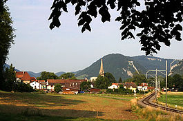
Môtiers
Môtiers | |
|---|---|
Former municipality of Switzerland | |
 | |
 Coat of arms | |
Location of Môtiers | |
 Môtiers Show map of Switzerland 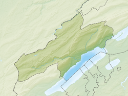 Môtiers Show map of Canton of Neuchâtel | |
| Coordinates: 46°55′N 6°37′E / 46.917°N 6.617°E / 46.917; 6.617Coordinates: 46°55′N 6°37′E / 46.917°N 6.617°E / 46.917; 6.617 | |
| Country | Switzerland |
| Canton | Neuchâtel |
| District | Val-de-Travers |
| Area | |
| • Total | 6.42 km2 (2.48 sq mi) |
| Elevation | 737 m (2,418 ft) |
| Population (December 2007) | |
| • Total | 825 |
| • Density | 130/km2 (330/sq mi) |
| Postal code | 2112 |
| SFOS number | 6507 |
| Surrounded by | Couvet, Boveresse, Fleurier |
| Website | motiers.ne.ch SFSO statistics |
Môtiers was a municipality in the district of Val-de-Travers in the canton of Neuchâtel in Switzerland. On 1 January 2009, the former municipalities of Boveresse, Buttes, Couvet, Fleurier, Les Bayards, Môtiers, Noiraigue, Saint-Sulpice and Travers merged to form the administrative district of Val-de-Travers.[1]
The old castle, dating in part from the 14th century, stands on a rock spur 1km due south of the village. Today the property of the canton of Neuchâtel, it is occasionally used to host cultural events.
Absinthe
Since the ban on absinthe was lifted in March 2005, Môtiers has become the focal point of production and promotion of the fée verte. Acknowledging the fact that absinthe was illicitly distilled in the area for generations, the Val de Travers chose Môtiers for the national Maison de l'Absinthe, opened in July 2014, even though neighbouring Couvet claims to be the place where the drink originated.
People
Jean-Jacques Rousseau sought and found protection in Môtiers under Lord Keith, who was the local representative of the free-thinking Frederick the Great of Prussia. While living in Môtiers, Rousseau was visited by James Boswell (December 1764) and drafted a Constitution for Corsica (Projet de Constitution pour la Corse, 1765). After his house was stoned on the night of 6 September 1765, Rousseau left to seek refuge in Great Britain with David Hume, who found lodgings for him at a friend's country estate in Wootton in Staffordshire.
References
^ Amtliches Gemeindeverzeichnis der Schweiz published by the Swiss Federal Statistical Office (in German) accessed 14 January 2010
| Wikimedia Commons has media related to Môtiers. |
This Canton of Neuchâtel location article is a stub. You can help Wikipedia by expanding it. |


