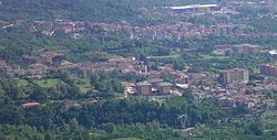
Fisciano
| Fisciano | ||
|---|---|---|
| Comune | ||
| Comune di Fisciano | ||
 | ||
| ||
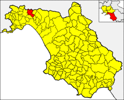 Fisciano within the Province of Salerno | ||
 Fisciano Location of Fisciano in Italy | ||
| Coordinates: 40°46′N 14°48′E / 40.767°N 14.800°E / 40.767; 14.800Coordinates: 40°46′N 14°48′E / 40.767°N 14.800°E / 40.767; 14.800 | ||
| Country | Italy | |
| Region | Campania | |
| Province | Salerno (SA) | |
| Frazioni | Bolano, Canfora, Carpineto, Gaiano, Lancusi, Penta, Pizzolano, Settefichi, Soccorso, Villa | |
| Government | ||
| • Mayor | Vincenzo Sessa | |
| Area | ||
| • Total | 31.48 km2 (12.15 sq mi) | |
| Elevation | 320 m (1,050 ft) | |
| Population (28 February 2017)[1] | ||
| • Total | 13,930 | |
| • Density | 440/km2 (1,100/sq mi) | |
| Demonym(s) | Fiscianesi | |
| Time zone | UTC+1 (CET) | |
| • Summer (DST) | UTC+2 (CEST) | |
| Postal code | 84080, 84084 | |
| Dialing code | 089 | |
| Patron saint | St. Vincent Ferrer | |
| Saint day | 5 April | |
| Website | Official website | |

Fisciano is a town and comune in the province of Salerno in the Campania region of south-western Italy. It is dominated by the University of Salerno, which built a new campus in the town in 1988.[2]
The municipality borders with Baronissi, Calvanico, Castiglione del Genovesi, Giffoni Sei Casali, Mercato San Severino and Montoro.
Contents
1 Economy
2 Transport
3 See also
4 References
5 External links
Economy
The economy is based on agriculture and animal husbandry; the traditional copper working activities ceased in the 1980s, although there are some industrial plants (metal-working/ mechanics, glass and plastics sectors).
Transport
Fisciano is served by a railway station on the line Salerno-Mercato San Severino.
See also
- University of Salerno
References
^ (in Italian) Source: Istat 2010
^ (in Italian) Info and address at University of Salerno website
External links
![]() Media related to Fisciano at Wikimedia Commons
Media related to Fisciano at Wikimedia Commons
This Campanian location article is a stub. You can help Wikipedia by expanding it. |


