Moone

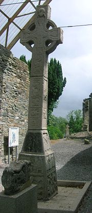
High Cross of Moone

Moone - left, the road to Athy

Moone, Main Street (former N9)
Moone (Irish: Maen Colmcille, meaning "Colmcille's property") is a small village in the south of County Kildare, Ireland. It is on the former N9 road (now by-passed) about 80 km (50 mi) south of Dublin. It has only a few hundred inhabitants, a church, a National School, one shop and a small community centre. There is also pub called the Moone High Cross Inn.[1]
Contents
1 Etymology
2 Location, access and development
3 The High Cross
4 Sport
5 External links
6 See also
7 References
Etymology
The name Moone comes from the Irish "Maen Colmcille" which means "Colmcille's property".
Location, access and development
The closest village to Moone is Timolin, about 1 kilometer to the north. The current county plan provides for joint development of Moone and Timolin.
The village is served by bus route 880 operated by Kildare Local Link on behalf of the National Transport Authority. There are several buses each day including Sunday linking the village to Castledermot, Carlow and Naas as well as villages in the area.[2]
The High Cross
Moone's most famous attribute is its High Cross, dating from the 7th century. It can be found about 1 kilometre from Moone along the road to Athy (at 52°58′48″N 6°49′31″W / 52.98000°N 6.82528°W / 52.98000; -6.82528) in the remains of an old abbey believed to have been established by Saint Colmcille. A good picture and description of the High Cross can be found
here.
Sport
The leading National Hunt trainer Jessica Harrington has her stables at Moone. Her famous horses have included Moscow Flyer, Macs Joy, Jezki and Sizing John
There is a local soccer club called Moone Celtic FC, the club's crest is a high cross obviously taken from the local structure. The club's pitch is Fortfield Park, which is located on the old n9 to Carlow.
External links
Kildare County Council page for Moone has more information.
See also
List of towns and villages in Ireland.- List of abbeys and priories in Ireland (County Kildare)
References
^ County Kildare: Moone
^ http://www.martinheydon.com/2015/08/1879/
Coordinates: 52°59′N 6°49′W / 52.983°N 6.817°W / 52.983; -6.817
This article related to the geography of County Kildare, Ireland is a stub. You can help Wikipedia by expanding it. |
