Frankfurt Rhine-Main
Frankfurt Rhine-Main Metropolitan Region | |
|---|---|
 Map of the Frankfurt Rhine-Main metropolitan region | |
| Country | |
| States | |
| Largest Cities | Frankfurt am Main Darmstadt Mainz Offenbach Wiesbaden |
| Government [1] | |
| • Type | Frankfurt/Rhine-Main Conurbation Planning Association |
| • Verbandsdirektor | Heiko Kasseckert (CDU) |
| Area | |
| • Metro | 14,800 km2 (5,700 sq mi) |
| Population | |
| • Metro | 5,821,523 |
| • Metro density | 391.89/km2 (1,015.0/sq mi) |
| Time zone | UTC+1 (CET) |
| GRP | 2012 |
| Nominal | €172/ $222 billion (6th in EU) |
| Website | Planungsverband.de |
The Frankfurt Rhine-Main Metropolitan Region, often simply referred to as Frankfurt Rhine-Main, Frankfurt Rhine-Main area or Rhine-Main area (German: Frankfurt/Rhein-Main, abbreviated FRM) is the third largest metropolitan region in Germany (after Ruhr and Berlin), with a total population exceeding 5.8 million. The metropolitan region is located in the central western part of Germany, and stretches over parts of three federal states: Hesse, Rhineland-Palatinate and Bavaria, as well as the cities of Frankfurt am Main, Wiesbaden, Offenbach, Mainz, Darmstadt and Aschaffenburg.
The polycentric region is named after its core city Frankfurt am Main and the two rivers Rhine and Main. The Frankfurt Rhine-Main area is officially designated as a European Metropolitan region by the German Federal Ministry of Transport, Building and Urban Affairs and covers an area of roughly 13,000 square kilometers (5,000 sq mi).
Contents
1 Subdivisions
1.1 Metropolitan region and larger urban zones
2 Cities and districts
3 Traffic
4 Education
5 See also
6 Gallery
7 References
8 External links
Subdivisions
Rhine-Main is a polycentric metropolitan region, but the economic size and political weight of the city of Frankfurt sets it into a very monocentric relation with her commuter belt. Since the early 1970s the Frankfurt am Main metropolitan area (German: Ballungsraum Frankfurt/Rhein-Main) is defined as an area encompassing the cities of Frankfurt and Offenbach and their directly neighboring districts.
The Regierungsbezirk Darmstadt of the state of Hesse could be seen as the next administrative division, as it lies entirely within the metropolitan region and further includes the cities of Darmstadt and Wiesbaden and a number of larger districts. Only on a level further, the metropolitan region also includes the cities and districts of Mainz and Aschaffenburg in the two adjoining federal states of Rhineland-Palatinate and Bavaria.
Metropolitan region and larger urban zones
Eurostat's Urban Audit splits the Frankfurt Rhine-Main region into four Larger Urban Zones (LUZ). These zones do exclude a number of districts in the metropolitan area.
| Hierarchy of planning bodies | Major cities | Area | Population | Refs |
|---|---|---|---|---|
| Frankfurt am Main | 248 km² | 750,000 | — | |
| Offenbach am Main | 45 km² | 118,245 | — | |
| 4,305 km² | 2,517,561 | [2] | |
| Wiesbaden | 204 km² | 275,489 | — | |
| Darmstadt | 122 km² | 142,191 | — | |
| 7,445 km² | 3,778,689 | — | |
| Mainz | 98 km² | 196,784 | — | |
| Aschaffenburg | 63 km² | 68,646' | — | |
| 14,800 km² | 5,821,523 | — | |
| Larger Urban Zone | Major cities | Area | Population | Refs |
| 4,305 km² | 2,517,561 | [3] | |
| Frankfurt am Main | 248 km² | 670,095 | [4] | |
| Offenbach am Main | 45 km² | 118,245 | [5] | |
| 1,015 km² | 459,633 | [6] | |
| Wiesbaden | 204 km² | 275,489 | [7] | |
| 781 km² | 430,993 | [8] | |
| Darmstadt | 122 km² | 142,191 | [9] | |
| 704 km² | 386,173 | [10] | |
| Mainz | 98 km² | 196,784 | [11] | |
Cities and districts
| Picture | City or district | Area | Population |
|---|---|---|---|
 | Frankfurt am Main | 248 km² | 750,000 |
 | Offenbach am Main | 45 km² | 118,245 |
 | Landkreis Offenbach | 356 km² | 337,986 |
 | Main-Kinzig-Kreis | 1,397 km² | 411,956 |
 | Wetteraukreis | 122 km² | 142,191 |
 | Hochtaunuskreis | 482 km² | 233,427 |
| — | Main-Taunus-Kreis | 122 km² | 142,191 |
 | Darmstadt | 122 km² | 142,191 |
 | Landkreis Darmstadt-Dieburg | 659 km² | 289,102 |
 | Landkreis Groß-Gerau | 453 km² | 253,502 |
 | Wiesbaden | 204 km² | 275,489 |
 | Rheingau-Taunus-Kreis | 98 km² | 196,784 |
Subtotal | Hesse | 7,445 km² | 3,778,689 |
 | Mainz | 98 km² | 196,784 |
 | Mainz-Bingen | 606 km² | 201,451 |
| — | Worms | 109 km² | 81,784 |
| — | Landkreis Alzey-Worms | 588 km² | 124,758 |
Subtotal | Rhineland-Palatinate | 1405 km² | 604,777 |
 | Aschaffenburg | 63 km² | 68,646 |
| — | Landkreis Aschaffenburg | 699 km² | 173,946 |
 | Landkreis Miltenberg | 716 km² | 130,009 |
Subtotal | Bavaria | 1,478 km² | 372,601 |
Total | Frankfurt Rhine-Main metropolitan region | 14,800 km² | 5,800,000 |
Traffic
The growth of the area is chiefly to be traced to the favorable communications, that promoted an early industrialization. Today however, the importance of industrial concerns has to a great extent been replaced by banking, trade and logistics. Frankfurt lies within the populous Blue Banana region of Europe, which here runs along the Rhine valley, and the city is also a stepping stone from and to various parts of Switzerland and Southern Germany. The Rhine-Ruhr is accessible via a one-hour trip on the Cologne–Frankfurt high-speed rail line, and the air route Frankfurt-Berlin is the busiest in German domestic air travel.
Frankfurt Airport is the busiest airport by passenger traffic in Germany and one of the three busiest airports in Europe. Thereby, along with a strong railway connection, the area also serves as a major transportation hub.
Education
The Frankfurt/Rhine-Main metropolitan region is home to five universities and over 20 partly postgraduate colleges, with a total of over 200,000 students. The region's three public research universities, the
Goethe University Frankfurt,
Johannes Gutenberg University Mainz,and
TU Darmstadt,
make up the Rhine Main Universities[12] alliance. Private universities in the Frankfurt/Rhine-Main metropolitan region are
- EBS University of Business and Law
Frankfurt School of Finance & Management.
Notable colleges and universities of applied sciences (Fachhochschulen) include:
- Darmstadt University of Applied Sciences
- Frankfurt University of Applied Sciences
- RheinMain University of Applied Sciences
- Frankfurt University of Music and Performing Arts
- Städelschule
- University of Applied Sciences, Mainz
- Catholic University of Applied Sciences, Mainz
See also
- Global city
Gallery

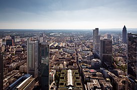
Frankfurt is the most important city of the Rhein-Main area

Rheingau

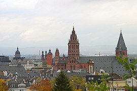
Old town of Mainz

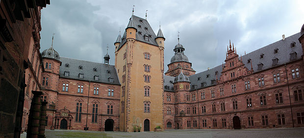
Castle of Johannisburg in Aschaffenburg

German House of Goldsmiths in Hanau

Rhenish Hesse

Darmstadt Artists' Colony

Town Hall of Michelstadt
References
^ Regionalverband FrankfurtRheinMain. "Regionalverband FrankfurtRheinMain /". planungsverband.de..mw-parser-output cite.citation{font-style:inherit}.mw-parser-output q{quotes:"""""""'""'"}.mw-parser-output code.cs1-code{color:inherit;background:inherit;border:inherit;padding:inherit}.mw-parser-output .cs1-lock-free a{background:url("//upload.wikimedia.org/wikipedia/commons/thumb/6/65/Lock-green.svg/9px-Lock-green.svg.png")no-repeat;background-position:right .1em center}.mw-parser-output .cs1-lock-limited a,.mw-parser-output .cs1-lock-registration a{background:url("//upload.wikimedia.org/wikipedia/commons/thumb/d/d6/Lock-gray-alt-2.svg/9px-Lock-gray-alt-2.svg.png")no-repeat;background-position:right .1em center}.mw-parser-output .cs1-lock-subscription a{background:url("//upload.wikimedia.org/wikipedia/commons/thumb/a/aa/Lock-red-alt-2.svg/9px-Lock-red-alt-2.svg.png")no-repeat;background-position:right .1em center}.mw-parser-output .cs1-subscription,.mw-parser-output .cs1-registration{color:#555}.mw-parser-output .cs1-subscription span,.mw-parser-output .cs1-registration span{border-bottom:1px dotted;cursor:help}.mw-parser-output .cs1-hidden-error{display:none;font-size:100%}.mw-parser-output .cs1-visible-error{font-size:100%}.mw-parser-output .cs1-subscription,.mw-parser-output .cs1-registration,.mw-parser-output .cs1-format{font-size:95%}.mw-parser-output .cs1-kern-left,.mw-parser-output .cs1-kern-wl-left{padding-left:0.2em}.mw-parser-output .cs1-kern-right,.mw-parser-output .cs1-kern-wl-right{padding-right:0.2em}
^ Regionalverband FrankfurtRheinMain. "Regionalverband FrankfurtRheinMain /". planungsverband.de.
^ "City Profiles".
^ "Frankfurt a.M. - Städtestatistik im Internet". staedtestatistik.de.
^ "Umlichen_Ebenen_des_UrbanAudit" (PDF).
^ "City Profiles".
^ "Wiesbaden, LH - Städtestatistik im Internet". staedtestatistik.de.
^ "Country Code". Archived from the original on 2012-03-20.
^ "Darmstadt - Städtestatistik im Internet". staedtestatistik.de.
^ "Country Code".
^ "Mainz, LH - Städtestatistik im Internet". staedtestatistik.de.
^ "Rhine Main Universities". 2018-04-23.
External links
| Wikimedia Commons has media related to Rhein-Main. |
| Wikivoyage has a travel guide for Rhine-Main. |
- Planungsverband Ballungsraum Frankfurt/Rhein-Main Frankfurt/Rhine-Main Conurbation Planning Association
- Region Frankfurt RheinMain online - Gateway to Europe
- Frankfurt International Airport
- Rhein-Main Metropolitan Transit
- Frankfurt Economic Support
- Frankfurt/Rhein-Main 2020 – the European metropolitan region
- One region - Boundless possibilities
Coordinates: 50°06′N 8°42′E / 50.1°N 8.7°E / 50.1; 8.7


