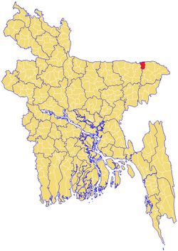
Companiganj Upazila, Sylhet
Companigonj (Sylhet) কোম্পানীগঞ্জ | |
|---|---|
 Location of Companigonj (Sylhet) কোম্পানীগঞ্জ chearnen mobile number | |
| Division | Sylhet Division |
| District | Sylhet District |
| Government | |
| • MP (Sylhet-4) | Imran Ahmad (Awami League) |
| Area | |
| • Total | 278.55 km2 (107.55 sq mi) |
| Population | |
| • Total | 85,169 |
| • Density | 310/km2 (790/sq mi) |
| Demonym(s) | Companiganji, Compenigonji, Compenigonzi |
| Time zone | UTC+6 (BST) |
| Postal code | 3140 |
Companiganj (Bengali: কোম্পানীগঞ্জ) is an Upazila of Sylhet District in the Division of Sylhet, Bangladesh.[1]
Contents
1 Geography
2 Demographics
3 Administration
4 See also
5 References
Geography
Companiganj Upazila (sylhet district) area 278.55 sq km, located in between 24°58' and 25°11' north latitudes and in between 91°41' and 91°53' east longitudes.
Demographics
Companiganj Upazila (sylhet district) area 278.55 sq km, located in between 24°58' and 25°11' north latitudes and in between 91°41' and 91°53' east longitudes. It is bounded by Meghalaya (state of India) on the north, sylhet sadar, gowainghat and chhatak upazilas on the south, Gowainghat upazila on the east and Chhatak upazila on the west.
Population Total 113784; male 59758, female 54026; Muslim 104200, Hindu 9522 and others 62. Indigenous communities such as khasia, manipuri belong to this upazila.
Water bodies Main rivers: surma and piyain; noted baors: Baowa, Lali, Loba, Poko; noted beels: Panichhapara, Nigar, Rauti and Kalenga.
Administration
Companigonj has 6 Unions/Wards, 76 Mauzas/Mahallas, and 131 villages.
The unions are:
- Islampur West Union
- Islampur East Union
- Ranikhai North Union
- Ranikhai South Union
- Telikhal 1 Union
- Isakalash Union
See also
- Upazilas of Bangladesh
- Districts of Bangladesh
- Divisions of Bangladesh
References
^ Jayanta Singh Roy (2012), "Companiganj Upazila (Sylhet District)", in Sirajul Islam and Ahmed A. Jamal, Banglapedia: National Encyclopedia of Bangladesh (Second ed.), Asiatic Society of Bangladesh.mw-parser-output cite.citation{font-style:inherit}.mw-parser-output .citation q{quotes:"""""""'""'"}.mw-parser-output .citation .cs1-lock-free a{background:url("//upload.wikimedia.org/wikipedia/commons/thumb/6/65/Lock-green.svg/9px-Lock-green.svg.png")no-repeat;background-position:right .1em center}.mw-parser-output .citation .cs1-lock-limited a,.mw-parser-output .citation .cs1-lock-registration a{background:url("//upload.wikimedia.org/wikipedia/commons/thumb/d/d6/Lock-gray-alt-2.svg/9px-Lock-gray-alt-2.svg.png")no-repeat;background-position:right .1em center}.mw-parser-output .citation .cs1-lock-subscription a{background:url("//upload.wikimedia.org/wikipedia/commons/thumb/a/aa/Lock-red-alt-2.svg/9px-Lock-red-alt-2.svg.png")no-repeat;background-position:right .1em center}.mw-parser-output .cs1-subscription,.mw-parser-output .cs1-registration{color:#555}.mw-parser-output .cs1-subscription span,.mw-parser-output .cs1-registration span{border-bottom:1px dotted;cursor:help}.mw-parser-output .cs1-ws-icon a{background:url("//upload.wikimedia.org/wikipedia/commons/thumb/4/4c/Wikisource-logo.svg/12px-Wikisource-logo.svg.png")no-repeat;background-position:right .1em center}.mw-parser-output code.cs1-code{color:inherit;background:inherit;border:inherit;padding:inherit}.mw-parser-output .cs1-hidden-error{display:none;font-size:100%}.mw-parser-output .cs1-visible-error{font-size:100%}.mw-parser-output .cs1-maint{display:none;color:#33aa33;margin-left:0.3em}.mw-parser-output .cs1-subscription,.mw-parser-output .cs1-registration,.mw-parser-output .cs1-format{font-size:95%}.mw-parser-output .cs1-kern-left,.mw-parser-output .cs1-kern-wl-left{padding-left:0.2em}.mw-parser-output .cs1-kern-right,.mw-parser-output .cs1-kern-wl-right{padding-right:0.2em}
Source Bangladesh Population Census 2001, Bangladesh Bureau of Statistics.
This Sylhet Division location article is a stub. You can help Wikipedia by expanding it. |
