Koszalin County

Multi tool use
County in West Pomeranian, Poland
Koszalin County
Powiat koszaliński
|
County |
 Flag
|
 Coat of arms
|
|
 Location within the voivodeship
|
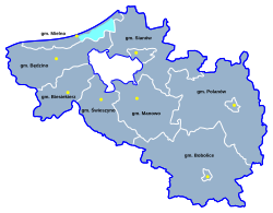
 Division into gminas
|
Coordinates (Koszalin): 54°11′N 16°11′E / 54.183°N 16.183°E / 54.183; 16.183Coordinates: 54°11′N 16°11′E / 54.183°N 16.183°E / 54.183; 16.183
|
Country |
Poland
|
Voivodeship |
West Pomeranian |
Seat |
Koszalin |
Gminas |
Total 8
- Gmina Będzino
- Gmina Biesiekierz
- Gmina Bobolice
- Gmina Manowo
- Gmina Mielno
- Gmina Polanów
- Gmina Sianów
- Gmina Świeszyno
|
Area
|
• Total |
1,669.09 km2 (644.44 sq mi) |
Population (2006)
|
• Total |
64,087 |
• Density |
38/km2 (99/sq mi) |
• Urban
|
13,956 |
• Rural
|
50,131 |
Car plates |
ZKO |
Website |
http://www.powiat.koszalin.pl |
Koszalin County (Polish: powiat koszaliński) is a unit of territorial administration and local government (powiat) in West Pomeranian Voivodeship, north-western Poland, on the Baltic coast. It came into being on January 1, 1999, as a result of the Polish local government reforms passed in 1998. Its administrative seat is the city of Koszalin, although the city is not part of the county (it constitutes a separate city county). The county contains three towns: Sianów, 10 km (6 mi) north-east of Koszalin, Bobolice, 37 km (23 mi) south-east of Koszalin, and Polanów, 35 km (22 mi) east of Koszalin.
The county covers an area of 1,669.09 square kilometres (644.4 sq mi). As of 2006 its total population is 64,087, out of which the population of Sianów is 6,543, that of Bobolice is 4,446, that of Polanów is 2,967, and the rural population is 50,131.
Neighbouring counties
Apart from the city of Koszalin, Koszalin County is also bordered by Sławno County, Słupsk County and Bytów County to the east, Szczecinek County and Białogard County to the south, and Kołobrzeg County to the west. It also borders the Baltic Sea to the north.
Administrative division
The county is subdivided into eight gminas (three urban-rural and five rural). These are listed in the following table, in descending order of population.
Gmina
|
Type
|
Area (km²)
|
Population (2006)
|
Seat
|
Gmina Sianów
|
urban-rural
|
226.8
|
13,251
|
Sianów
|
Gmina Bobolice
|
urban-rural
|
367.7
|
9,905
|
Bobolice
|
Gmina Będzino
|
rural
|
180.9
|
9,287
|
Będzino
|
Gmina Polanów
|
urban-rural
|
393.1
|
9,194
|
Polanów
|
Gmina Manowo
|
rural
|
188.6
|
6,322
|
Manowo
|
Gmina Świeszyno
|
rural
|
132.6
|
5,621
|
Świeszyno
|
Gmina Biesiekierz
|
rural
|
116.9
|
5,439
|
Biesiekierz
|
Gmina Mielno
|
rural
|
62.5
|
5,068
|
Mielno
|
References
- Polish official population figures 2006
Koszalin County
|
Urban-rural gminas |
- Gmina Bobolice
- Gmina Polanów
- Gmina Sianów
|
|
Rural gminas |
- Gmina Będzino
- Gmina Biesiekierz
- Gmina Manowo
- Gmina Mielno
- Gmina Świeszyno
|
Seat (not part of the county) |
|
Counties of West Pomeranian Voivodeship
|
City counties |
Szczecin (capital)
- Koszalin
- Świnoujście
|
|
Land counties |
- Białogard
- Choszczno
- Drawsko
- Goleniów
- Gryfice
- Gryfino
- Kamień
- Kołobrzeg
- Koszalin
- Łobez
- Myślibórz
- Police
- Pyrzyce
- Sławno
- Stargard
- Świdwin
- Szczecinek
- Wałcz
|
E,75TAQUaJlCz,vDPng
Popular posts from this blog
Place in Moyen-Ogooué, Gabon Lambaréné Street in Lambaréné Lambaréné Location in Gabon Coordinates: 0°41′18″S 10°13′55″E / 0.68833°S 10.23194°E / -0.68833; 10.23194 Coordinates: 0°41′18″S 10°13′55″E / 0.68833°S 10.23194°E / -0.68833; 10.23194 Country Gabon Province Moyen-Ogooué Population (2013 census) • Total 38,775 Lambaréné is a town and the capital of Moyen-Ogooué in Gabon. With a population of 38,775 as of 2013, it is located 75 kilometres south of the equator. Lambaréné is based in the Central African Rainforest at the river Ogooué. This river divides the city into 3 districts: Rive Gauche, Ile Lambaréné and Rive Droite. The Albert Schweitzer Hospital and the districts Adouma and Abongo are located on Rive Droite. The districts Atongowanga, Sahoty, Dakar, Grand Village, Château, Lalala and Bordamur build the Ile Lambaréné. The majority of the people in Lambaréné live in the district Isaac located on Rive Gauche. This distr...
This article is about the number. For the year, see 800. For other uses, see 800 (disambiguation). Natural number ← 799 800 801 → List of numbers — Integers ← 0 100 200 300 400 500 600 700 800 900 → Cardinal eight hundred Ordinal 800th (eight hundredth) Factorization 2 5 × 5 2 Greek numeral Ω´ Roman numeral DCCC Binary 1100100000 2 Ternary 1002122 3 Quaternary 30200 4 Quinary 11200 5 Senary 3412 6 Octal 1440 8 Duodecimal 568 12 Hexadecimal 320 16 Vigesimal 200 20 Base 36 M8 36 800 ( eight hundred ) is the natural number following 799 and preceding 801. It is the sum of four consecutive primes (193 + 197 + 199 + 211). It is a Harshad number. Contents 1 Integers from 801 to 899 1.1 800s 1.2 810s 1.3 820s 1.4 830s 1.5 840s 1.6 850s 1.7 860s 1.8 870s 1.9 880s 1.10 890s 2 References Integers from 801 to 899 800s Main article: 801...
body.skin-minerva .mw-parser-output table.infobox caption{text-align:center} 維納斯堡 Venersborg (英文) CDP Venersborg, Washington 維納斯堡位置圖 坐标: 45°46′58″N 122°27′43″W / 45.7828°N 122.462°W / 45.7828; -122.462 國家 美國 州 華盛頓州 郡 克拉克县 面积 • 总计 27.8 平方公里(10.7 平方英里) • 陸地 27.8 平方公里(10.7 平方英里) • 水域 0.0 平方公里(0.0 平方英里) 海拔 155 米(509 英尺) 人口 (2000年) • 總計 3,274 • 密度 118.0/平方公里(305.6/平方英里) 时区 PST (UTC-8) • 夏时制 PDT(UTC-7) FIPS碼 53-74585 [1] GNIS編號 1527695 [2] 維納斯堡 ( 英语: Venersborg )是美国华盛顿州克拉克县的一個普查规定居民点(CDP),2000年美國人口普查時人口為2,085人。 最初為瑞典人聚居地。 參見 維納什堡 参考資料 ^ American FactFinder. United States Census Bureau. [ 2008-01-31 ] . ^ US Board on Geographic Names. United States Geological Survey. 2007-10-25 [ 2008-01-31 ] . 查 论 编 克拉克县 行政區劃 郡治 : 溫哥華 市 巴特爾格朗德 | 卡默斯 | 拉申特 | 里奇菲尔德 | 溫哥華 | 瓦休戈 | 林地市‡ 鎮 亞科爾特 CDP 安波伊 | 巴伯頓 | 布拉什普雷里 | 櫻桃樹叢區 | ...