Sarbisheh County
Sarbisheh County شهرستان سربیشه | |
|---|---|
| County | |
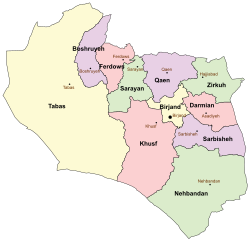 South Khorasan counties | |
 Location of South Khorasan Province in Iran | |
| Coordinates: 32°24′N 60°05′E / 32.400°N 60.083°E / 32.400; 60.083Coordinates: 32°24′N 60°05′E / 32.400°N 60.083°E / 32.400; 60.083 | |
| Country | |
| Province | South Khorasan Province |
| Capital | Sarbisheh |
Bakhsh (Districts) | Central District, Mud District |
| Population (2006) | |
| • Total | 37,591 |
| Time zone | UTC+3:30 (IRST) |
| • Summer (DST) | UTC+4:30 (IRDT) |
Sarbisheh County at GEOnet Names Server | |
Sarbisheh County (Persian: شهرستان سربیشه) is a county in South Khorasan Province in Iran. The capital of the county is Sarbisheh. At the 2006 census, the county's population was 37,591, in 10,119 families.[1] The county consists of two districts: Central District and Mud District. The county has two cities: Sarbisheh and Mud.
Sarbisheh is Persian for "forest gate", and contains the last remaining dry forests of southern Khorasan in its surrounding mountains.
References
^ "Census of the Islamic Republic of Iran, 1385 (2006)". Islamic Republic of Iran. Archived from the original (Excel) on 2011-11-11..mw-parser-output cite.citation{font-style:inherit}.mw-parser-output q{quotes:"""""""'""'"}.mw-parser-output code.cs1-code{color:inherit;background:inherit;border:inherit;padding:inherit}.mw-parser-output .cs1-lock-free a{background:url("//upload.wikimedia.org/wikipedia/commons/thumb/6/65/Lock-green.svg/9px-Lock-green.svg.png")no-repeat;background-position:right .1em center}.mw-parser-output .cs1-lock-limited a,.mw-parser-output .cs1-lock-registration a{background:url("//upload.wikimedia.org/wikipedia/commons/thumb/d/d6/Lock-gray-alt-2.svg/9px-Lock-gray-alt-2.svg.png")no-repeat;background-position:right .1em center}.mw-parser-output .cs1-lock-subscription a{background:url("//upload.wikimedia.org/wikipedia/commons/thumb/a/aa/Lock-red-alt-2.svg/9px-Lock-red-alt-2.svg.png")no-repeat;background-position:right .1em center}.mw-parser-output .cs1-subscription,.mw-parser-output .cs1-registration{color:#555}.mw-parser-output .cs1-subscription span,.mw-parser-output .cs1-registration span{border-bottom:1px dotted;cursor:help}.mw-parser-output .cs1-hidden-error{display:none;font-size:100%}.mw-parser-output .cs1-visible-error{font-size:100%}.mw-parser-output .cs1-subscription,.mw-parser-output .cs1-registration,.mw-parser-output .cs1-format{font-size:95%}.mw-parser-output .cs1-kern-left,.mw-parser-output .cs1-kern-wl-left{padding-left:0.2em}.mw-parser-output .cs1-kern-right,.mw-parser-output .cs1-kern-wl-right{padding-right:0.2em}
- اطلس گیتاشناسی استانهای ایران [Atlas Gitashenasi Ostanhai Iran] (Gitashenasi Province Atlas of Iran)
| Capital |
|    | |||||||||||||||||||||
|---|---|---|---|---|---|---|---|---|---|---|---|---|---|---|---|---|---|---|---|---|---|---|---|
Counties and cities |
| ||||||||||||||||||||||
| Sights |
| ||||||||||||||||||||||
| populated places |
| ||||||||||||||||||||||
| Capital |
| ||||||||||||||||||||
|---|---|---|---|---|---|---|---|---|---|---|---|---|---|---|---|---|---|---|---|---|---|
| Districts |
| ||||||||||||||||||||
This Sarbisheh County location article is a stub. You can help Wikipedia by expanding it. |


