大都市帶

Multi tool use
全球城市人口排名表 |
 |
- 世界最大城市
- 市域人口最多的城市
- 世界最大城市地区
- 大都会区
- 组合城市
- 超大城市
- 大都市带
|
{{导航模板}} |
|

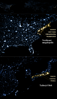
上為美國波士頓-華盛頓城市帶,下為日本太平洋工業帶
大都市帶(英语:megalopolis,亦作megapolis、megaregion或supercity),又译大都市区,通指大致相鄰的都會區的鏈,它們可能在某種程度上分離,也可能連成一片連續的城市區域。中文的城市群與之概念相近。
世界主要的大都市帶有美國的波士頓-華盛頓城市帶、五大湖区城市群,日本的太平洋沿岸城市群,中国的长江三角洲城市群、珠江三角洲城市群等。
詞語歷史
帕特里克·格迪斯在1915年出版的《进化中的城市》(Cities in Evolution)中、[1]奧斯瓦爾德·斯賓格勒在1918年出版的《西方的衰落》(The Decline of the West)一书中分別使用了“megalopolis”这一术语;刘易斯·芒福德]在1938年的《城市文化》(The Culture of Cities)一书中将其描述为城市过度发育和社会衰退的第一阶段。后来,簡·戈特曼在其1961年具有里程碑意义的研究《Megalopolis: The Urbanized Northeastern Seaboard of the United States》(大都市带:城市化的美国东北海岸)中使用该词描述美国东北沿海的大都市区,该大都市区自马萨诸塞州的波士顿起,经纽约、费城和巴尔的摩,止于华盛顿特区和弗吉尼亚州北部。[2][3][4]后者有时被称为“波士华大都市带”(BosWash megalopolis)。该术语被解释为“超级城市”(supercity)的意思。[5]
定義
大都市帶一詞的英文為“megalopolis”,有時亦作“megapolis”,來自希臘語的“μέγας”(mégas,意為“大”)和“πόλις”(pólis,意為“都市”),字面意思即「大都市」(另見巨型都市)。由於希臘語中πόλις為陰性,因此從詞源上看,更合理的拼法是“megalopolis”。从字面上看,希腊语中的megalopolis指一个尺度夸张的城市,其中前缀megalo-代表了一定程度的夸张。[6]
大都市带是指城市的集群网络。戈特曼将其人口定为2500万。[7]Doxiadis将小型的大都市区定义为人口约1000万的相似集群。[8][9][10]区域规划协会的一个项目“美国2050”列出了美国和加拿大的11个megaregion(字面意思为“大区”)。[8]2005年7月弗吉尼亚理工大学大都会研究所的Robert E. Lang和Dawn Dhavale的报告深入研究了美国的大都市区。[11]后来Lang和Nelson在2007年的一篇论文中使用了20个大都市区,并分为10个megaregion。[12]该概念基于原始的Megalopolis模型。[10]
现代相互连接的地面交通走廊,如铁路和公路,往往有助于大都市区的发展。英语中,使用这些通勤通道在大都市区中旅行被非正式地称作“megaloping”。该词由Davide Gadren和Stefan Berteau创造。[13]
在巴西,和大都市带意思相近的词语mesorregião和microrregião在法律上是有区分的,并且意思不同,例如Mesoregions of Brazil (mesorregião)和Microregions of Brazil (microrregião)。
在中国,“城市群”和“都市圈”等术语曾长期混用。1998年的《城市规划基本术语标准》(GB/T 50280-98)将城市群定义为“一定地域内城市分布较为密集的地区”,英文翻译为“agglomeration”,但实际上该词的意思是市区,其尺度小于都市圈,而都市圈尺度小于城市群。
參考文獻
^ Geddes, Patrick. Cities in Evolution. London: Williams & Norgate. 1915 –通过Internet Archive.
^ Gottmann, Jean. L'Amerique. Paris: Hachette. 1954.
^ Gottmann, Jean. Megalopolis, or the urbanization of the Northeastern Seaboard. Economic Geography. 1957, 33 (3): 189–200. JSTOR 142307. doi:10.2307/142307.
^ Gottmann, Jean. Megalopolis. The Urbanized Northeastern seaboard of the United States. New York: The Twentieth Century Fund. 1961.
^ Fielder, W.; Feeney, Georgiana. Inquiring about Cities: Student text. Holt, Rinehart and Winston. 1976: 193, 299 [2018-06-25]. ISBN 9780030897849. (原始内容存档于2018-06-25) (英语).
^ Definition of the prefix megalo-. The American Heritage® Dictionary of the English Language, Fourth Edition copyright ©2000 by Houghton Mifflin Company. Updated in 2009. Published by Houghton Mifflin Company. All rights reserved.
^ Gottmann, Jean. Since Megalopolis. The Urban Writings of Jean Gottmann. Baltimore and London: The Johns Hopkins University Press. 1989: 163.
^ 8.08.1 Taylor, Matt. Megaregions. America 2050. [2017-04-06]. (原始内容存档于2017-05-16).
^ Who's Your City?: What Is a Megaregion?. 19 March 2008 [5 October 2014]. (原始内容存档于12 June 2010).
^ 10.010.1 Cities: Capital for the New Megalopolis 互联网档案馆的存檔,存档日期2013-08-27..Time magazine, November 4, 1966. Retrieved on July 19, 2010.
^ Beyond Megalopolis: Exploring America's New "Megapolitan" Geography (PDF). July 2005. (原始内容 (PDF)存档于2009-03-27).
^ America 2040: The Rise of the Megapolitans (PDF). January 2007 [2014-01-05]. (原始内容存档 (PDF)于2013-07-24).
^ Tremble, Sam. Fumbling Toward Portland. Philadelphia City Paper. May 30, 2007. (原始内容存档于July 7, 2009).
World Urbanization Prospects: The 2005 revision (PDF).
城市与区域规划
|
|
基本概念 |
城市 - 区域 - 区位 - 市区 - 市域 - 市中心 - 中央商务区(CBD) - 建成區 - 郊區 - 新区 - 城市规划区 - 城市边缘地区 - 都市圈 - 城市群 - 城镇体系 - 城市化 - 郊区城市化 - 逆城市化 - 再城市化 - 城市更新
|
|
|
研究方向 |
城市规划 |
土地利用规划 - 土地使用分區 - 区域规划 - 城镇体系规划 - 城市設計 - 智慧城市 - 收缩城市
|
|
环境规划 |
環境設計 - 园林设计 - 景觀設計 - 綠色建築 - 环境影响评价 - 城市承载力 - 生态城市 - 可持续发展 - 低影响开发 - 韌性城市
|
|
交通规划 |
公共交通 - 公共交通导向型开发 - 上盖开发
|
|
|
城市规划理念 |
田园城市理论 - 城市美化运动 - 300万人口的现代城市 - 光辉城市 - 雅典宪章 - 邻里单位 - 线形城市 - 有机疏散理论 - 广亩城市 - 理性主义规划理论 - 马丘比丘宪章 - 新都市主義 - 新城运动 - 技术郊区 - 紧凑城市 - 精明增长 - 城市新区 - 组团式城市群 - 新型城镇化
|
|
区域理论 |
中心地理论 - 增长极理论 - 点轴理论 - 城镇体系
|
|
各類城市 |
全球城市 - 超大城市 - 门户城市 - 組合城市 - 边缘城市 - 卫星城市 - 新市鎮 - 公司市鎮 - 放射型城市 - 卧城 - 雙城 - 收缩城市
|
|
面临问题 |
城市蔓延 - 卧城 - 贫民窟 - 绅士化 - 城市衰退 - 屏風樓 - 爛尾建築 - 鬼城 - 交通堵塞 - 环境污染 - 內澇 - 熱島效應
|
|
量化指标 |
容积率 - 建筑密度 - 城镇化水平 (各国城市化比率) - 首位度 - 城市人口密度
|
|
交叉学科 |
地理學 - 建筑学 - 土木工程 - 土地开发 - 海洋空间规划 - 市政工程学 - 城市地理学 - 人文地理学 - 都市社會學 - 城市经济学 - 人口学 - 政治学 - 公共政策 - 社会科学 - 都市生態學 - 风水学 - 风景园林学 - 環境科學
|
|
其他 |
近现代城市规划理论与实践列表 - 城市史 - 城市规划史 - 中国城市规划 - 城市規劃師
|
|
地方实践 |
巴黎改造 - 大上海都市计划 - 臺灣市區改正 - 天津城市规划 - 香港新市鎮 - 粵港澳大灣區
|
|
世界最大城市
|
|
市域 |
|
|
城市群 |
|
|
市區(組合城市) |
|
|
市區(单一城市) |
|
|
相關條目 |
|
|
lP,kYoLSlHi2
Popular posts from this blog
Place in Moyen-Ogooué, Gabon Lambaréné Street in Lambaréné Lambaréné Location in Gabon Coordinates: 0°41′18″S 10°13′55″E / 0.68833°S 10.23194°E / -0.68833; 10.23194 Coordinates: 0°41′18″S 10°13′55″E / 0.68833°S 10.23194°E / -0.68833; 10.23194 Country Gabon Province Moyen-Ogooué Population (2013 census) • Total 38,775 Lambaréné is a town and the capital of Moyen-Ogooué in Gabon. With a population of 38,775 as of 2013, it is located 75 kilometres south of the equator. Lambaréné is based in the Central African Rainforest at the river Ogooué. This river divides the city into 3 districts: Rive Gauche, Ile Lambaréné and Rive Droite. The Albert Schweitzer Hospital and the districts Adouma and Abongo are located on Rive Droite. The districts Atongowanga, Sahoty, Dakar, Grand Village, Château, Lalala and Bordamur build the Ile Lambaréné. The majority of the people in Lambaréné live in the district Isaac located on Rive Gauche. This distr...
This article is about the number. For the year, see 800. For other uses, see 800 (disambiguation). Natural number ← 799 800 801 → List of numbers — Integers ← 0 100 200 300 400 500 600 700 800 900 → Cardinal eight hundred Ordinal 800th (eight hundredth) Factorization 2 5 × 5 2 Greek numeral Ω´ Roman numeral DCCC Binary 1100100000 2 Ternary 1002122 3 Quaternary 30200 4 Quinary 11200 5 Senary 3412 6 Octal 1440 8 Duodecimal 568 12 Hexadecimal 320 16 Vigesimal 200 20 Base 36 M8 36 800 ( eight hundred ) is the natural number following 799 and preceding 801. It is the sum of four consecutive primes (193 + 197 + 199 + 211). It is a Harshad number. Contents 1 Integers from 801 to 899 1.1 800s 1.2 810s 1.3 820s 1.4 830s 1.5 840s 1.6 850s 1.7 860s 1.8 870s 1.9 880s 1.10 890s 2 References Integers from 801 to 899 800s Main article: 801...
body.skin-minerva .mw-parser-output table.infobox caption{text-align:center} 維納斯堡 Venersborg (英文) CDP Venersborg, Washington 維納斯堡位置圖 坐标: 45°46′58″N 122°27′43″W / 45.7828°N 122.462°W / 45.7828; -122.462 國家 美國 州 華盛頓州 郡 克拉克县 面积 • 总计 27.8 平方公里(10.7 平方英里) • 陸地 27.8 平方公里(10.7 平方英里) • 水域 0.0 平方公里(0.0 平方英里) 海拔 155 米(509 英尺) 人口 (2000年) • 總計 3,274 • 密度 118.0/平方公里(305.6/平方英里) 时区 PST (UTC-8) • 夏时制 PDT(UTC-7) FIPS碼 53-74585 [1] GNIS編號 1527695 [2] 維納斯堡 ( 英语: Venersborg )是美国华盛顿州克拉克县的一個普查规定居民点(CDP),2000年美國人口普查時人口為2,085人。 最初為瑞典人聚居地。 參見 維納什堡 参考資料 ^ American FactFinder. United States Census Bureau. [ 2008-01-31 ] . ^ US Board on Geographic Names. United States Geological Survey. 2007-10-25 [ 2008-01-31 ] . 查 论 编 克拉克县 行政區劃 郡治 : 溫哥華 市 巴特爾格朗德 | 卡默斯 | 拉申特 | 里奇菲尔德 | 溫哥華 | 瓦休戈 | 林地市‡ 鎮 亞科爾特 CDP 安波伊 | 巴伯頓 | 布拉什普雷里 | 櫻桃樹叢區 | ...