Pons, Charente-Maritime
This article may be expanded with text translated from the corresponding article in French. (December 2008) Click [show] for important translation instructions.
|
Pons | |
|---|---|
Commune | |
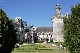
 The Castle | |
 Coat of arms | |
Location of Pons | |
 Pons Show map of France  Pons Show map of Nouvelle-Aquitaine | |
| Coordinates: 45°34′52″N 0°32′49″W / 45.5811°N 0.5469°W / 45.5811; -0.5469Coordinates: 45°34′52″N 0°32′49″W / 45.5811°N 0.5469°W / 45.5811; -0.5469 | |
| Country | France |
| Region | Nouvelle-Aquitaine |
| Department | Charente-Maritime |
| Arrondissement | Jonzac |
| Canton | Pons |
| Intercommunality | Région de Pons |
| Government | |
| • Mayor .mw-parser-output .nobold{font-weight:normal} (2008–2014) | Henri Méjean |
| Area 1 | 27.63 km2 (10.67 sq mi) |
| Population (2008)2 | 4,427 |
| • Density | 160/km2 (410/sq mi) |
| Time zone | UTC+01:00 (CET) |
| • Summer (DST) | UTC+02:00 (CEST) |
INSEE/Postal code | 17283 /17800 |
| Elevation | 8–63 m (26–207 ft) |
1 French Land Register data, which excludes lakes, ponds, glaciers > 1 km2 (0.386 sq mi or 247 acres) and river estuaries. 2Population without double counting: residents of multiple communes (e.g., students and military personnel) only counted once. | |
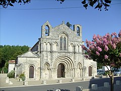
Pons is a commune in the Charente-Maritime department in southwestern France. The city is known for its numerous national historic monuments dating from the 12 century on wards [1]. One of the most well known is the 33 meter high Keep of Pons the which is the official symbol of the city.
Contents
1 Geography
2 Population
3 Gallery
4 See also
5 References
6 External Links
Geography
The Seugne flows north through the middle of the commune and crosses the town.
Population
| Historical population | ||
|---|---|---|
| Year | Pop. | ±% |
| 1793 | 4,031 | — |
| 1800 | 3,803 | −5.7% |
| 1806 | 3,429 | −9.8% |
| 1821 | 3,605 | +5.1% |
| 1831 | 3,726 | +3.4% |
| 1836 | 4,294 | +15.2% |
| 1841 | 4,543 | +5.8% |
| 1846 | 4,661 | +2.6% |
| 1851 | 4,765 | +2.2% |
| 1856 | 4,757 | −0.2% |
| 1861 | 4,894 | +2.9% |
| 1866 | 4,969 | +1.5% |
| 1872 | 4,738 | −4.6% |
| 1876 | 4,881 | +3.0% |
| 1881 | 4,895 | +0.3% |
| 1886 | 4,764 | −2.7% |
| 1891 | 4,615 | −3.1% |
| 1896 | 4,717 | +2.2% |
| 1901 | 4,772 | +1.2% |
| 1906 | 4,470 | −6.3% |
| 1911 | 4,549 | +1.8% |
| 1921 | 4,368 | −4.0% |
| 1926 | 4,427 | +1.4% |
| 1931 | 4,375 | −1.2% |
| 1936 | 4,266 | −2.5% |
| 1946 | 4,442 | +4.1% |
| 1954 | 4,629 | +4.2% |
| 1962 | 4,753 | +2.7% |
| 1968 | 4,824 | +1.5% |
| 1975 | 4,878 | +1.1% |
| 1982 | 4,861 | −0.3% |
| 1990 | 4,412 | −9.2% |
| 1999 | 4,433 | +0.5% |
| 2008 | 4,427 | −0.1% |
Gallery
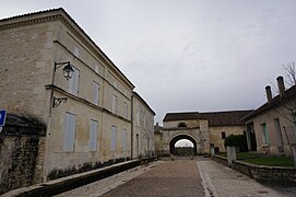
Pilgrim hospital, via Turonensis, World Heritage, way of st-James.
Keep.
Museum.
Château d'Usson, a medieval theme-park for children[2]

church.
Éolienne Bollée.
Church.
See also
- Communes of the Charente-Maritime department
References
- INSEE
^ Joy, Diane (2005). "Charente-Maritime. Pons, inventaire du patrimoine médiéval de la ville". Bulletin Monumental. 163: 375–378 – via Persee..mw-parser-output cite.citation{font-style:inherit}.mw-parser-output .citation q{quotes:"""""""'""'"}.mw-parser-output .citation .cs1-lock-free a{background:url("//upload.wikimedia.org/wikipedia/commons/thumb/6/65/Lock-green.svg/9px-Lock-green.svg.png")no-repeat;background-position:right .1em center}.mw-parser-output .citation .cs1-lock-limited a,.mw-parser-output .citation .cs1-lock-registration a{background:url("//upload.wikimedia.org/wikipedia/commons/thumb/d/d6/Lock-gray-alt-2.svg/9px-Lock-gray-alt-2.svg.png")no-repeat;background-position:right .1em center}.mw-parser-output .citation .cs1-lock-subscription a{background:url("//upload.wikimedia.org/wikipedia/commons/thumb/a/aa/Lock-red-alt-2.svg/9px-Lock-red-alt-2.svg.png")no-repeat;background-position:right .1em center}.mw-parser-output .cs1-subscription,.mw-parser-output .cs1-registration{color:#555}.mw-parser-output .cs1-subscription span,.mw-parser-output .cs1-registration span{border-bottom:1px dotted;cursor:help}.mw-parser-output .cs1-ws-icon a{background:url("//upload.wikimedia.org/wikipedia/commons/thumb/4/4c/Wikisource-logo.svg/12px-Wikisource-logo.svg.png")no-repeat;background-position:right .1em center}.mw-parser-output code.cs1-code{color:inherit;background:inherit;border:inherit;padding:inherit}.mw-parser-output .cs1-hidden-error{display:none;font-size:100%}.mw-parser-output .cs1-visible-error{font-size:100%}.mw-parser-output .cs1-maint{display:none;color:#33aa33;margin-left:0.3em}.mw-parser-output .cs1-subscription,.mw-parser-output .cs1-registration,.mw-parser-output .cs1-format{font-size:95%}.mw-parser-output .cs1-kern-left,.mw-parser-output .cs1-kern-wl-left{padding-left:0.2em}.mw-parser-output .cs1-kern-right,.mw-parser-output .cs1-kern-wl-right{padding-right:0.2em}
^ "Family Guide France - DK Travel - Google Books". Https:. Retrieved December 21, 2018.
External Links
|Official website for the city of Pons (French)
| Wikimedia Commons has media related to Pons (Charente-Maritime). |
This Charente-Maritime geographical article is a stub. You can help Wikipedia by expanding it. |


