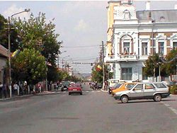
Gherla
Gherla | ||
|---|---|---|
Municipality | ||
 | ||
| ||
 Location on Romania map | ||
| Coordinates: 47°1′12″N 23°54′0″E / 47.02000°N 23.90000°E / 47.02000; 23.90000Coordinates: 47°1′12″N 23°54′0″E / 47.02000°N 23.90000°E / 47.02000; 23.90000 | ||
| Country | ||
| County | ||
| Status | Municipality | |
| Government | ||
| • Mayor | Ioan Neselean (Social Democratic Party) | |
| Area | ||
| • Total | 36.3 km2 (14.0 sq mi) | |
| Population (October 20, 2011)[1] | ||
| • Total | 20,203 | |
| • Density | 560/km2 (1,400/sq mi) | |
| Time zone | UTC+2 (EET) | |
| • Summer (DST) | UTC+3 (EEST) | |
| Website | http://www.gherlainfo.ro/ | |
Gherla (Romanian pronunciation: [ˈɡerla]; Hungarian: Szamosújvár; German: Neuschloss) is a city in Cluj County, Romania (in the historical region of Transylvania). It is located 45 km from Cluj-Napoca on the Someșul Mic River, and has a population of 20,203. Three villages are administered by the city: Băița (formerly Chirău, and Kérő in Hungarian), Hășdate (Szamoshesdát) and Silivaș (Vizszilvás).
The city was formerly known as Armenopolis[2] (Armenian: Հայաքաղաք Hayakaghak; German: Armenierstadt; Hungarian: Örményváros) because it was populated by Armenians.[3]
Contents
1 History
2 Population
3 Natives
4 References
5 Sources
6 External links
History
| Historical population | ||
|---|---|---|
| Year | Pop. | ±% |
| 1910 | 6,857 | — |
| 1930 | 6,608 | −3.6% |
| 1948 | 6,663 | +0.8% |
| 1956 | 7,617 | +14.3% |
| 1966 | 12,766 | +67.6% |
| 1977 | 17,599 | +37.9% |
| 1992 | 26,277 | +49.3% |
| 2002 | 24,232 | −7.8% |
| 2011 | 20,203 | −16.6% |
| Source: Census data | ||
A clay tablet containing a fragmentary Old Persian cuneiform of the Achaemenid king Darius I was found at Gherla in 1937. It may be connected to Darius I's epigraphic activities in relation to his Scythian campaign of 513 BC as reported by Herodotus.[4][5][6]
The locality was first recorded in 1291 as a village named Gherlahida, (probably derived from the Slavic word grle, meaning "ford"). The second name was Armenian, Հայաքաղաք Hayakaghak, meaning "Armenian city"; it took the Medieval Latin and Greek official name Armenopolis, as well as the German alternative name Armenierstadt. Later, the name Szamosújvár was used in official Hungarian records, meaning "the new town on the Someș". Before 1918, Gherla was part of the Kingdom of Hungary comitatus of Szolnok-Doboka. It was again part of Hungary between 1940-1944.

Armenian Catholic Cathedral
The modern city was built in the early 18th century by Armenians, successors of the Cilician Armenian diaspora, who had originally settled in Crimea and Moldavia, and moved to Transylvania sometime after 1650. After a two years' campaign by the Armenian-Catholic Bishop Oxendius Vărzărescu, they converted from the Armenian Apostolic Church to the Armenian Catholic Church.[citation needed]
Gherla is the seat of the Ordinariate for Catholics of Armenian Rite in Romania, as well as that of a Greek-Catholic diocese – the Cluj-Gherla Diocese (suffragan to the Greek-Catholic Archbishop of Alba Iulia and Făgăraș-Blaj, who resided in Blaj). In the center of the city lie the Saint Gregory the Illuminator and the Holy Trinity Armenian Cathedral. The main Armenian-Catholic church was built in 1792. The Greek Catholic diocese was created by the Papal Bull Ad Apostolicam Sedem of November 26, 1853, and the first bishop was Ioan Alexi.
A Habsburg fortress was built here and converted to a prison in 1785. During the Communist regime, the prison was used for political detainees (see Gherla prison). Today it is a Romanian high-security prison.
The town is often visited by Orthodox pilgrims on their way to the nearby village of Nicula and Nicula Monastery.
Population
According to the 2011 Romanian census, there were 20,203 people living within the city, as follows:[1]
- 15,994 (79.2%) Romanians
- 3,419 (16.9%) Hungarians
- 718 (3.6%) Roma
- 72 (0.4%) others, including 16 Germans
Natives
- Tamás Aján
- Gergely Pongrátz
- Silviu Prigoană
References
^ ab "Comunicat de presă privind rezultatele provizorii ale Recensământului Populaţiei şi Locuinţelor – 2011" (PDF). Cluj County Regional Statistics Directorate. 2012-02-02. Retrieved 2012-02-14..mw-parser-output cite.citation{font-style:inherit}.mw-parser-output .citation q{quotes:"""""""'""'"}.mw-parser-output .citation .cs1-lock-free a{background:url("//upload.wikimedia.org/wikipedia/commons/thumb/6/65/Lock-green.svg/9px-Lock-green.svg.png")no-repeat;background-position:right .1em center}.mw-parser-output .citation .cs1-lock-limited a,.mw-parser-output .citation .cs1-lock-registration a{background:url("//upload.wikimedia.org/wikipedia/commons/thumb/d/d6/Lock-gray-alt-2.svg/9px-Lock-gray-alt-2.svg.png")no-repeat;background-position:right .1em center}.mw-parser-output .citation .cs1-lock-subscription a{background:url("//upload.wikimedia.org/wikipedia/commons/thumb/a/aa/Lock-red-alt-2.svg/9px-Lock-red-alt-2.svg.png")no-repeat;background-position:right .1em center}.mw-parser-output .cs1-subscription,.mw-parser-output .cs1-registration{color:#555}.mw-parser-output .cs1-subscription span,.mw-parser-output .cs1-registration span{border-bottom:1px dotted;cursor:help}.mw-parser-output .cs1-ws-icon a{background:url("//upload.wikimedia.org/wikipedia/commons/thumb/4/4c/Wikisource-logo.svg/12px-Wikisource-logo.svg.png")no-repeat;background-position:right .1em center}.mw-parser-output code.cs1-code{color:inherit;background:inherit;border:inherit;padding:inherit}.mw-parser-output .cs1-hidden-error{display:none;font-size:100%}.mw-parser-output .cs1-visible-error{font-size:100%}.mw-parser-output .cs1-maint{display:none;color:#33aa33;margin-left:0.3em}.mw-parser-output .cs1-subscription,.mw-parser-output .cs1-registration,.mw-parser-output .cs1-format{font-size:95%}.mw-parser-output .cs1-kern-left,.mw-parser-output .cs1-kern-wl-left{padding-left:0.2em}.mw-parser-output .cs1-kern-right,.mw-parser-output .cs1-kern-wl-right{padding-right:0.2em}
[permanent dead link]
^ Mallows, Lucy (2008). Transylvania. Chalfont St. Peter: Bradt Travel Guides. p. 256. ISBN 9781841622309.
^ Steve Kokker, Cathryn Kemp (2004). Romania & Moldova. Footscray, Victoria: Lonely Planet. p. 159. ISBN 9781741041491.Gherla Once a predominantly Armenian settlement called Armenopolis in the 17th century...
^ Kuhrt 2013, p. 197.
^ Frye 1984, p. 103.
^ Schmitt 2000, p. 53.
Sources
Kuhrt, A. (2013). The Persian Empire: A Corpus of Sources from the Achaemenid Period. Routledge. ISBN 978-1136016943.
Frye, Richard Nelson (1984). Handbuch der Altertumswissenschaft: Alter Orient-Griechische Geschichte-Römische Geschichte. Band III,7: The History of Ancient Iran. C.H.Beck. ISBN 978-3406093975.
Schmitt, Rüdiger (2000). The Old Persian Inscriptions of Naqsh-i Rustam and Persepolis. Corpus Inscriptionum Iranicarum by School of Oriental and African Studies. ISBN 978-0728603141.
External links
| Wikimedia Commons has media related to Gherla. |
Armenierstadt This article incorporates text from a publication now in the public domain: Herbermann, Charles, ed. (1913). "article name needed". Catholic Encyclopedia. New York: Robert Appleton.
Armenians in Romania at the Central European University site

