Keratea
This article may be expanded with text translated from the corresponding article in Greek. (August 2012) Click [show] for important translation instructions.
|
Keratea Κερατέα | |
|---|---|
 Keratea Location within the regional unit 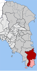 | |
| Coordinates: 37°48′N 23°58′E / 37.800°N 23.967°E / 37.800; 23.967Coordinates: 37°48′N 23°58′E / 37.800°N 23.967°E / 37.800; 23.967 | |
| Country | Greece |
| Administrative region | Attica |
| Regional unit | East Attica |
| Municipality | Lavreotiki |
| • Municipal unit | 129.864 km2 (50.141 sq mi) |
| Elevation | 158 m (518 ft) |
| Population (2011)[1] | |
| • Municipal unit | 14,763 |
| • Municipal unit density | 110/km2 (290/sq mi) |
| Time zone | UTC+2 (EET) |
| • Summer (DST) | UTC+3 (EEST) |
| Postal code | 190 01 |
| Area code(s) | 22990 |
| Vehicle registration | Z |
| Website | www.keratea.gr |
Keratea (Greek: Κερατέα) is a town in East Attica, Greece. Since the 2011 local government reform it is part of the municipality Lavreotiki, of which it is a municipal unit. The municipal unit has an area of 129.864 km2.[2] Legend has it that when the barbarians came to attack Greece at the land of Keratea, Zeus and Hedes drew the coast together so they can talk and allowed only a strip of water in between. The Greeks were so very few so to give them a fighting chance Zeus and Hades summoned Poseidonis and asked him to send waves bigger than the barbarians ships.People from that time say that even the Hades himself fought on the side of the Greeks. So the sea by the land of Keratea is known as Kakia Thalassa (the Bad Sea) ever since.[3]
Contents
1 Geography
2 Historical population
3 Historical monuments
4 Sports
5 See also
6 References
7 External links
Geography
Keratea is situated in the hills in the southeastern part of the Attica peninsula, 6 km west of the Aegean Sea coast, at about 200 m elevation. It lies at the northern foot of Mount Paneion. It is 5 km southeast of Kalyvia Thorikou, 12 km northwest of Lavrio and 29 km southeast of Athens city centre. Greek National Road 89 (Gerakas - Koropi - Lavrio - Sounio) passes through Keratea.
In antiquity, the area of present Keratea was part of the deme Cephale, of the phyle Acamantis in Mesogeia area of Ancient Athens.
Historical population
| Year | Town population | Municipality population |
|---|---|---|
| 1981 | 7,511 | - |
| 1991 | 6,512 | 9,715 |
| 2001 | 7,472 | 11,205 |
| 2011 | 7,493 | 14,763 |
Historical monuments
The church of St.Athanasius (Kronizes)[4]. A wall painting monument (1744) of George Markou the Argus, the great and prolific post-Byzantine ecclesiastic iconographer of the 18th century (".... Il Santo Athanasio, che si trova alla Regione Cronizes di Kerateas dell 'Attica...." Evangelos Andreou http://ketlib.lib.unipi.gr/xmlui/handle/ket/849 )
Sports
Keratea hosts the sport teams Keravnos Keratea F.C., one of the most successful East Attica football clubs, and the multi-sport G.S. Kerateas (Gymnastikos Syllogos Kerateas), the women's volleyball team has represent the town in Greek A1 Division for several years.
See also
- List of municipalities of Attica
References
^ ab "Απογραφή Πληθυσμού - Κατοικιών 2011. ΜΟΝΙΜΟΣ Πληθυσμός" (in Greek). Hellenic Statistical Authority..mw-parser-output cite.citation{font-style:inherit}.mw-parser-output q{quotes:"""""""'""'"}.mw-parser-output code.cs1-code{color:inherit;background:inherit;border:inherit;padding:inherit}.mw-parser-output .cs1-lock-free a{background:url("//upload.wikimedia.org/wikipedia/commons/thumb/6/65/Lock-green.svg/9px-Lock-green.svg.png")no-repeat;background-position:right .1em center}.mw-parser-output .cs1-lock-limited a,.mw-parser-output .cs1-lock-registration a{background:url("//upload.wikimedia.org/wikipedia/commons/thumb/d/d6/Lock-gray-alt-2.svg/9px-Lock-gray-alt-2.svg.png")no-repeat;background-position:right .1em center}.mw-parser-output .cs1-lock-subscription a{background:url("//upload.wikimedia.org/wikipedia/commons/thumb/a/aa/Lock-red-alt-2.svg/9px-Lock-red-alt-2.svg.png")no-repeat;background-position:right .1em center}.mw-parser-output .cs1-subscription,.mw-parser-output .cs1-registration{color:#555}.mw-parser-output .cs1-subscription span,.mw-parser-output .cs1-registration span{border-bottom:1px dotted;cursor:help}.mw-parser-output .cs1-hidden-error{display:none;font-size:100%}.mw-parser-output .cs1-visible-error{font-size:100%}.mw-parser-output .cs1-subscription,.mw-parser-output .cs1-registration,.mw-parser-output .cs1-format{font-size:95%}.mw-parser-output .cs1-kern-left,.mw-parser-output .cs1-kern-wl-left{padding-left:0.2em}.mw-parser-output .cs1-kern-right,.mw-parser-output .cs1-kern-wl-right{padding-right:0.2em}
^ "Population & housing census 2001 (incl. area and average elevation)" (PDF) (in Greek). National Statistical Service of Greece. Archived from the original (PDF) on 2015-09-21.
^ Kallikratis law Greece Ministry of Interior (in Greek)
^ ".:BiblioNet : Γεώργιος Μάρκου ο Αργείος / Ανδρέου, Ευάγγελος". www.biblionet.gr. Retrieved 2018-11-16.
External links
Official website (in Greek, link to English version available)- http://members.tripod.com/~Mesogia_Keratea/
- https://web.archive.org/web/20060515075537/http://www.athleticsclubkeratea.org/
Antenna on Keratea's hydrogen factory (in Greek)
"Violence spikes in Greek rebel town" by Elena Becatoros, The Independent, 16 April 2011
http://www.forkeratea.com Η ηλεκτρονικη αρχειοθηκη δημοσιευσεων που αφορουν την πολη της Κερατεας και το δημο Λαυρεωτικής.
Places adjacent to Keratea | ||||||||||
|---|---|---|---|---|---|---|---|---|---|---|
| ||||||||||


