M8 motorway (Scotland)
M8 | ||||
|---|---|---|---|---|
 | ||||
 Looking eastbound from Charing Cross | ||||
| Route information | ||||
| Part of | ||||
| Maintained by Transport Scotland | ||||
| Length | 60.3 mi (97.0 km) | |||
| Existed | 1965–present | |||
| History | Opened: 1965 Completed: 2017 | |||
| Major junctions | ||||
| East end | Sighthill 55°55′28″N 3°18′46″W / 55.9244°N 3.3128°W / 55.9244; -3.3128 (M8 motorway (eastern end)) | |||
J2 → M9 motorway J8 → M73 motorway/A8(M) motorway J13 → M80 motorway J21 → M74 motorway J22 → M77 motorway J30 → M898 motorway | ||||
| West end | Langbank 55°55′24″N 4°33′01″W / 55.9234°N 4.5504°W / 55.9234; -4.5504 (M8 motorway (western end)) | |||
| Location | ||||
| Counties | Edinburgh, West Lothian, North Lanarkshire, Glasgow, Renfrewshire | |||
| Primary destinations | Edinburgh Edinburgh Airport Livingston Glasgow Paisley Glasgow Airport | |||
| Road network | ||||
| ||||

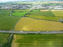
The M8 south of Broxburn, West Lothian
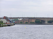
Kingston Bridge

M8 running alongside the Clyde

This stub in the Tradeston area, popularly known as the "ski-ramp", is the abandoned interchange for the southern flank of the Glasgow Inner Ring Road
The M8 is the busiest motorway in Scotland and one of the busiest in the United Kingdom.[1] It connects the country's two largest cities, Glasgow and Edinburgh, and serves other large communities including Airdrie, Coatbridge, Greenock, Livingston and Paisley. The motorway is 60 miles (97 km) long. A major construction project to build the final section between Newhouse and Baillieston was completed on 30 April 2017. The motorway has one service station, named Heart of Scotland Services, previously Harthill due to its proximity to the village.
Contents
1 Construction
2 Route
3 Criticism
4 Junctions
5 See also
6 References
7 External links
Construction
With the advent of motorway-building in the United Kingdom in the late 1950s, the M8 was planned as one of a core of new motorways, designed to replace the A8 road as a high-capacity alternative for intercity travel. The motorway was constructed piecemeal in several stages bypassing towns, beginning in 1965 with the opening by Minister of State for Scotland George Willis of the bypass of Harthill. In 1968 the Renfrew Bypass was opened as the A8(M), becoming part of the M8 when the motorway to the west was connected.[2] The Glasgow inner city section was constructed between 1968 and 1972, using a scheme outlined in the Bruce Report, which was published as the Second World War was closing, and which set out a series of initiatives to regenerate the city. Bruce's scheme evolved into what would become the Glasgow Inner Ring Road, a motorway "box" which would encircle the city centre, connected to the Renfrew Bypass at its south western corner, and the Monkland Motorway (built over the former route of the Monkland Canal) towards Edinburgh at its north eastern corner. Together, these three sections of motorway make up the present day M8.
Most of the motorway's length was complete by 1980. Since then, the only additions have been a new interchange with the M80 motorway in 1992, a 4-mile (6.4 km) eastern extension from Newbridge to the then-new Edinburgh City Bypass in 1995, and the new junction on the approach to the Kingston Bridge in Glasgow connecting to the new M74 extension in 2011.[3] As part of the Scottish Government's 'M8 M73 M74 Motorway Improvements programme', on which construction began in early 2015,[4] the remaining unfinished section between Baillieston (J8) and Newhouse (J6) was built, alongside other major improvements enhancing connectivity to the local road network, M73, and M74.[5] The new section was fully opened on 30 April 2017.[6]
Route

Sign at junction 2
From the Edinburgh City Bypass, the road runs west to junction with the M9 motorway (for the Forth Road Bridge), bypassing to the north of Livingston and south of Bathgate. It continues across Scotland's Central Belt. The next section – originally designated the Monkland Motorway – begins on the boundary of the City of Glasgow at the M73 motorway junction (the main interchange for all routes south via the M74 motorway) before passing through the districts of Barlanark, Riddrie, Dennistoun and Townhead (following the route of the abandoned Monkland Canal) on the way directly into the city centre. The central section – the uncompleted Glasgow Inner Ring Road – contains numerous junctions serving local communities including Cowcaddens, Garnethill, Kelvingrove and Anderston. It then crosses the River Clyde on the Kingston Bridge, runs west through Kinning Park, Bellahouston and Hillington before leaving Glasgow. Continuing west, it bypasses Renfrew and Paisley (carrying traffic directly over what was the main runway at Renfrew Airport, closed in 1966) before serving Glasgow International Airport, running to the south of Erskine, and terminating at Langbank, around 10 miles (16 km) east of Greenock.[7]
The M8 nominally comprises sections of the international E-road network, namely E05 (Langbank-Baillieston)[8] and E16 (Baillieston-Edinburgh),[9] although neither is signposted – no such roads are in the United Kingdom.
Criticism
The M8, more explicitly the Glasgow section, is unusual amongst UK motorways (and more similar to many US Interstates) in that it directly serves (and bisects) a large urban area, whereas most other motorways bypass such conurbations. The central Glasgow section is elevated above much of the surrounding area on a concrete viaduct, including several incomplete constructions such as several pedestrian overpasses and adjoining arterial roads, and has slip roads that enter and exit from the passing (right-hand) lane. It contains one of the busiest river crossings in Europe at the Kingston Bridge. The speed limit there is reduced to 50 mph (80 km/h) as a result.
There were successive failed attempts to build the southern flank of the Glasgow Inner Ring Road as defined by the Bruce Report. This section of road, which is an extension of the M74, differs in route from the original Bruce proposals of the late 1940s, and was intended to funnel long distance traffic from the north and south which is bound for the southern Clyde Coast and allow it to bypass the urban section of the M8. Following many years of intensive political discussion and legal battles, construction of the M74 Completion scheme began in 2008, and it opened in June 2011. Early indications are that the new road has been successful in reducing traffic levels on the urban section of the M8.
The root cause of the high congestion on the urban section of the M8 is that traffic from the M73 and M80 is forced onto the eastern section of M8 which within 2 miles (3.2 km) converges from five lanes to two on the Kingston Bridge approaches. The result of this is often long periods of traffic congestion. Prior to the construction of the M74 extension, incentives were undertaken in an attempt to minimise delays on this section; these include restricting exits around the Kingston Bridge, a ramp metering programme, and expanded use of electronic signing above and beside the motorway as part of the CITRAC (Centrally Integrated TRAffic Control) system.[10][11]
The M8 represents a significant barrier to wildlife expansion, particularly the reintroduced beaver, from the north of Scotland into the Scottish Lowlands, Southern Uplands and Dumfries and Galloway.
Junctions
M8 motorway | ||
| Eastbound exits | Junction | Westbound exits |
M8 now terminates Edinburgh City Bypass A720 Berwick upon Tweed (A1) Edinburgh City Centre A71 | J1 | Start of motorway |
Edinburgh Airport, Stirling, Queensferry Crossing (M90) M9 | J2 | Stirling, Queensferry Crossing (M90) M9 |
Livingston A899 | J3 | Livingston A899 |
Bathgate, Broxburn, Livingston (West) (A779) A89 | J3a | Bathgate, Broxburn, Livingston (West) (A89) A779 |
| Bathgate, Whitburn, Falkirk A801 | J4 | Bathgate, Whitburn, Falkirk A801 |
| Whitburn, Heartlands (B7066) | J4a | Whitburn, Heartlands (B7066) |
Harthill services | ||
Shotts, Harthill, Salsburgh (B7066) B7057 | J5 | Shotts, Harthill, Salsburgh (B7066) B7057 |
| No access | J6 | Airdrie, Lanark, Motherwell, Wishaw, Eurocentral (A723) A73 |
| Lanark, Wishaw, Motherwell, Airdrie A8 (A73) | J6a | No access |
| Eurocentral | J7 | No access |
| No access | J7a | Carlisle (M74), East Kilbride, Bellshill A725 |
| Carlisle (M74) M73 Coatbridge A89 | J8 | Carlisle (M74), Glasgow (South), Glasgow Airport M73, Glasgow (East) A8 Stirling, Kincardine Bridge (M80) |
Baillieston | J9 | No access |
| Easterhouse, Barlanark | J10 | Easterhouse, Baillieston |
Garthamlock, Queenslie B765 | J11 | Stepps, Queenslie B765 |
Riddrie, Stepps A80 | J12 | Riddrie, Stepps A80 |
Stirling, Kincardine Bridge M80 | J13 | Blochairn, Parkhead |
| Blochairn, Dennistoun B763 | J14 | No access |
Glasgow Cathedral, Glasgow Cross, Kirkintilloch A803 | J15 | Glasgow Cathedral, Glasgow Cross A803 |
| No access | J16 | Aberfoyle, George Square (A81) |
Dumbarton A82 | J17 | Dumbarton A82 |
Anderston, Charing Cross (No exit from main carriageway) Glasgow city centre | J18 | Kelvingrove, Charing Cross |
Clydebank, S.E.C.C. A814 No exit from main carriageway | J19 | Clydebank, S.E.C.C. A814 |
| No access | J20 | Tradeston, East Kilbride (A730) |
Tradeston, East Kilbride (A8, A730) Carlisle M74 | J21 | No access |
| No access | J22 | Kilmarnock, Prestwick Airport M77 |
| No access | J23 | Govan, Ibrox B768 |
| Govan, Kilmarnock (M77) A761 | J24 | Paisley, Bellahouston A761 |
Clyde Tunnel A739 | J25 | Clyde Tunnel A739 |
| No access | J25a | Braehead |
Hillington, Braehead A736 | J26 | Hillington, Renfrew (A8) A736 |
Paisley, Renfrew A741 | J27 | Paisley, Renfrew A741 |
| No access | J28 | Glasgow Airport |
| No access | J28a | Irvine A737 |
Paisley, Glasgow Airport A726, Irvine A737 | J29 | Paisley A726 |
Erskine, Erskine Bridge M898 | J30 | Erskine, Erskine Bridge M898 |
Start of motorway | J31 | Bishopton A8 |
| Bishopton A8 Non-motorway traffic | Road becomes A8 towards Greenock | |
See also
- List of motorways in the United Kingdom
References
^ "Department for Transport - GOV.UK" (PDF). dft.gov.uk..mw-parser-output cite.citation{font-style:inherit}.mw-parser-output .citation q{quotes:"""""""'""'"}.mw-parser-output .citation .cs1-lock-free a{background:url("//upload.wikimedia.org/wikipedia/commons/thumb/6/65/Lock-green.svg/9px-Lock-green.svg.png")no-repeat;background-position:right .1em center}.mw-parser-output .citation .cs1-lock-limited a,.mw-parser-output .citation .cs1-lock-registration a{background:url("//upload.wikimedia.org/wikipedia/commons/thumb/d/d6/Lock-gray-alt-2.svg/9px-Lock-gray-alt-2.svg.png")no-repeat;background-position:right .1em center}.mw-parser-output .citation .cs1-lock-subscription a{background:url("//upload.wikimedia.org/wikipedia/commons/thumb/a/aa/Lock-red-alt-2.svg/9px-Lock-red-alt-2.svg.png")no-repeat;background-position:right .1em center}.mw-parser-output .cs1-subscription,.mw-parser-output .cs1-registration{color:#555}.mw-parser-output .cs1-subscription span,.mw-parser-output .cs1-registration span{border-bottom:1px dotted;cursor:help}.mw-parser-output .cs1-ws-icon a{background:url("//upload.wikimedia.org/wikipedia/commons/thumb/4/4c/Wikisource-logo.svg/12px-Wikisource-logo.svg.png")no-repeat;background-position:right .1em center}.mw-parser-output code.cs1-code{color:inherit;background:inherit;border:inherit;padding:inherit}.mw-parser-output .cs1-hidden-error{display:none;font-size:100%}.mw-parser-output .cs1-visible-error{font-size:100%}.mw-parser-output .cs1-maint{display:none;color:#33aa33;margin-left:0.3em}.mw-parser-output .cs1-subscription,.mw-parser-output .cs1-registration,.mw-parser-output .cs1-format{font-size:95%}.mw-parser-output .cs1-kern-left,.mw-parser-output .cs1-kern-wl-left{padding-left:0.2em}.mw-parser-output .cs1-kern-right,.mw-parser-output .cs1-kern-wl-right{padding-right:0.2em}
^ Steven Jukes. "Pathetic Motorways". pathetic.org.uk.
^ M8 motorway construction timeline Archived 9 October 2006 at the Wayback Machine, CRBD.co.uk
^ "Keeping communities informed". transportscotland.gov.uk. Archived from the original on 17 February 2015.
^ "M8 M73 M74 Motorway Improvements". transportscotland.gov.uk.
^ https://www.bbc.co.uk/news/uk-scotland-39762350
^ M8 motorway exit list Archived 9 October 2006 at the Wayback Machine, CBRD.co.uk
^ E05 route descriptor, elbruz.com
^ E16 route descriptor, elbruz.com
^ "Living in Glasgow – CITRAC". Glasgow.gov.uk. 25 August 2009. Retrieved 31 December 2011.
^ "Traffic Scotland > Variable Message Signs". trafficscotland.org.
External links
| Wikimedia Commons has media related to M8 motorway (Scotland). |
Route map:
KML file (edit • help) |
- Glasgow's Motorways - The M8 Motorway
- CBRD
- Motorway Database – M8
- Videos – M8
- Pathetic Motorways – A8(M) Renfrew Bypass
- The Motorway Archive – M8
- Eastern Scotland Section
- Western Scotland Section
Motorways in the United Kingdom | ||||||
|---|---|---|---|---|---|---|
| Great Britain |
|  | ||||
| Northern Ireland |
| |||||
| Former |
| |||||
| Unbuilt |
| |||||
| Proposed |
| |||||
| Junctions |
| |||||
| Related articles |
| |||||
| ||||||


