Bay of Kotor
Bay of Kotor Boka Kotorska Бока Которска | |
|---|---|
Geographic region of Montenegro | |
 Relief map | |
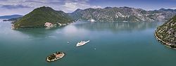 View over Bay of Kotor | |
| Country | |
| Towns | Kotor, Herceg Novi, Tivat, Risan, Dobrota, Perast, Prčanj |
| UNESCO World Heritage site | |
| Official name | Natural and Culturo-Historical Region of Kotor |
| Criteria | Cultural: i, ii, iii, iv |
| Reference | 125 |
| Inscription | 1979 (3rd Session) |
| Area | 14,600 ha |
| Buffer zone | 36,491 ha |
The Bay of Kotor (Montenegrin: Бока Которска, Boka Kotorska) pronounced [bɔ̂ka kɔ̂tɔrskaː]; Italian: Bocche di Cattaro), known simply as Boka ("the Bay"), is the name of the winding bay of the Adriatic Sea in southwestern Montenegro and the region of Montenegro concentrated around the bay.
The bay has been inhabited since antiquity. Its well-preserved medieval towns of Kotor, Risan, Tivat, Perast, Prčanj and Herceg Novi, along with their natural surroundings, are major tourist attractions. Natural and Culturo-Historical Region of Kotor has been a World Heritage Site since 1979. Its numerous Orthodox and Catholic churches and monasteries make it a major pilgrimage site.
Contents
1 Economy
2 Geography
2.1 Climate
2.2 Hydrology
3 History
3.1 Pre-Christian
3.2 Middle Ages
3.3 Fifteenth through seventeenth centuries
3.4 Modern history
4 Culture
4.1 Religious buildings
5 Demographics
5.1 Boka
5.1.1 Serbs & Montenegrins
5.1.2 Croats
6 Notable
7 Gallery
8 Literature
9 See also
10 References
11 External links
Economy
A small naval port is under development as a yacht marina, Porto Montenegro.
Geography

Municipalities of the Bay of Kotor (Kotor, Herceg Novi and Tivat) within Montenegro

Perast and Bay of Kotor from Saint Nicholas' Church

Bay of Kotor.
The bay is about 28 kilometres (17 mi) long with a shoreline extending 107.3 kilometres (66.7 mi). It is surrounded by two massifs of the Dinaric Alps: the Orjen mountains to the west, and the Lovćen mountains to the east. The narrowest section of the bay, the 2,300-metre (7,500 ft) long Verige Strait, is only 340 metres (1,120 ft) wide at its narrowest point.[1] The bay is a ria of the vanished Bokelj River that used to run from the high mountain plateaus of Mount Orjen.
The bay is composed of several smaller broad bays, united by narrower channels. The bay inlet was formerly a river system. Tectonic and karstification processes led to the disintegration of this river. After heavy rains the waterfall of Sopot spring at Risan appears, and Škurda, another well-known spring runs through a canyon from Lovćen.
The outermost part of the bay is the Bay of Tivat (Teodo). On the seaward side is the Bay of Herceg Novi (Castelnuovo), at the main entrance to the Bay of Kotor. The inner bays are the Bay of Risan to the northwest and the Bay of Kotor to the southeast.
The Verige Strait represents the bay's narrowest section and is located between Cape St. Nedjelja and Cape Opatovo; it separates the inner bay east of the strait from the Bay of Tivat.
Climate
The Bay lies within the Mediterranean and northwards the humid subtropical climate zone, but its peculiar topography and high mountains make it one of the wettest places in Europe, with Europe's wettest inhabited areas (although certain Icelandic glaciers are wetter[2]). The littoral Dinarids and the Prokletije mountains receive the most precipitation, leading to small glaciers surviving well above the 0 °C (32 °F) mean annual isotherm. November thunderstorms sometimes drop large amounts of water. By contrast, in August the area is frequently completely dry, leading to forest fires. With a maximum discharge of 200 m3/s (7,100 cu ft/s), one of the biggest karst springs, the Sopot spring, reflects this seasonal variation. Most of the time it is inactive but after heavy rain a remarkable waterfall appears 20 metres (66 ft) above the Bay of Kotor.
| Station | Height [m] | Type | Character | Precipitation [mm] | Snow |
|---|---|---|---|---|---|
Zubacki kabao | 1894 | D | perhumid Mediterranean snowclimate | ca. 6250 | ap. 140 days |
Crkvice | 940 | Cfsb | (fs= without summerdryness), perhumid Mediterranean mountain climate | 4926 | 70 days |
Risan | 0 | Cs’’a | (s’’= double winter rain season), perhumid Mediterranean coast climate | 3500 | 0.4 days |
*classification scheme after Köppen
Two wind systems have ecological significance: Bora and Jugo. Strong cold downslope winds of the Bora type appear in winter and are most severe in the Bay of Risan. Gusts reach 250 km/h (160 mph) and can lead to a significant temperature decline over several hours with freezing events. Bora weather situations are frequent and sailors study the mountains as cap clouds indicate an imminent Bora event. Jugo is a warm humid wind and brings heavy rain. It appears throughout the year but is usually concentrated in autumn and spring.
Monthly and yearly precipitation ranges:
| Station | Period | Height [m] | I | II | III | IV | V | VI | VII | VIII | IX | X | XI | XII | I-XII [mm/m²a] |
|---|---|---|---|---|---|---|---|---|---|---|---|---|---|---|---|
Herceg Novi | 1961–1984 | 40 | 230 | 221 | 183 | 135 | 130 | 73 | 28 | 45 | 160 | 181 | 326 | 262 | 1974 |
Risan | 1961–1984 | 40 | 405 | 342 | 340 | 235 | 153 | 101 | 66 | 123 | 188 | 295 | 423 | 434 | 3105 |
Grahovo | 1961–1984 | 710 | 351 | 324 | 305 | 251 | 142 | 94 | 55 | 103 | 202 | 416 | 508 | 473 | 3224 |
Podvrsnik | 1961–1984 | 630 | 407 | 398 | 367 | 305 | 151 | 101 | 77 | 132 | 238 | 465 | 593 | 586 | 3820 |
Vrbanj | 1961–1984 | 1010 | 472 | 390 | 388 | 321 | 181 | 104 | 70 | 122 | 224 | 369 | 565 | 536 | 3742 |
Knezlaz | 1961–1984 | 620 | 547 | 472 | 473 | 373 | 207 | 120 | 72 | 136 | 268 | 400 | 629 | 661 | 4358 |
Crkvice | 1961–1984 | 940 | 610 | 499 | 503 | 398 | 198 | 135 | 82 | 155 | 295 | 502 | 714 | 683 | 4774 |
Ivan. Korita | 1960–1984 | 1350 | 434 | 460 | 742 | 472 | 128 | 198 | 74 | 46 | 94 | 300 | 694 | 972 | 4614 |
Goli vrh | 1893–1913 | 1311 | 271 | 286 | 307 | 226 | 188 | 148 | 75 | 70 | 215 | 473 | 415 | 327 | 3129 |
Jankov vrh | 1890–1909 | 1017 | 424 | 386 | 389 | 346 | 212 | 124 | 55 | 58 | 202 | 484 | 579 | 501 | 3750 |
Hydrology
- Hydrologic system: karst hydrology ca. 4000 km², Sopot, Škurda, submerged sources[clarification needed]
- Water area: 87 km²
- Max depth: 60 m
- Average depth: 27.3 m
- Water content:24,12306 km³ (ca. 2.4 mrd m³)
- Highest point: Orjen (1894 m)
- Lowest point: sea surface (0 m)
- Length: 28,13 km
- Widest point: 7 km
- Narrowest point: || 0.3 km
History
Pre-Christian

Churches in the Bay of Kotor: 1) from the 9th and 2) 10th and 11th century

The Bay of Kotor within the Kingdom of Zeta in the 12th century
The nearby hamlet of Risan was a thriving Illyrian city called Rhizon as early as 229 BC and gave its name to the bay, then known as Rhizonicus Sinus. Queen Teuta of Illyria retired from Shkodra to Rhizon. Rhizon eventually submitted to Rome in 168 BC, at the same time that Acrivium, or Acruvium, the modern Kotor, was first mentioned.[citation needed]
Middle Ages
The Sklavenoi, South Slavs, settled in the Balkans in the 6th century.[3][4][5] The Serbs, mentioned in the Royal Frankish Annals of the mid-9th century, controlled a great part of Dalmatia ("Sorabos, quae natio magnam Dalmatiae partem obtinere dicitur").[6][7] The Slavic, Montenegrin tribes, consolidated under the Vlastimirović dynasty (610–960). The two principalities of Doclea and Travunia were roughly adjacent at Boka. As elsewhere in the Balkans, Slavs mixed with the Roman population of these Byzantine coastal cities. The Theme of Dalmatia was established in the 870s. According to De Administrando Imperio (ca. 960), Risan was part of Travunia, a Serbian principality ruled by the Belojević family.[citation needed]
After the Great Schism of 1054, the coastal region was officially under the Catholic Church (the West). In 1171, Stefan Nemanja sided with the Venetian Republic in a dispute with the Byzantine Empire. The Venetians incited the Slavs of the eastern Adriatic littoral to rebel against Byzantine rule and Nemanja joined them, launching an offensive towards Kotor. The Bay was thenceforth under the rule of the Nemanjić dynasty. In 1195 Nemanja and his son Vukan constructed the Church of Saint Luka in Kotor. In 1219 Saint Sava founded the seat of the Eparchy of Zeta on Prevlaka, one of the eparchies of the Serbian Orthodox Church. Due to its protected location, Kotor became a major city for the salt trade. The area flourished during the 14th century under the rule of Serbian emperor Dushan "The Mighty" who, notorious for his aggressive law enforcement, made the Bay of Kotor a particularly safe place for doing business.[8]
The town of Kotor was under Nemanjić rule until ca. 1370 when it became a part of the Kingdom of Bosnia. Its merchant fleet and importance gradually increased, and after the fall of Serbia to the Ottoman Empire in the late 14th century, Kotor was seized by the Venetian Republic. Part of the area was conquered by the Ottomans at the end of the 15th century, and the Venetian Republic held the southern part including Kotor. The Ottoman part was retaken at the end of the 17th century and the whole area became part of the Venetian Republic, with the name of Albania Veneta. Until the 20th century the difference between the two parts was visible because the former Ottoman part had an Orthodox majority, while the part that was under Venetian rule had a Catholic majority.[citation needed]
Fifteenth through seventeenth centuries
With the Ottoman expansion in the Balkans and fall of Serbian statehood in the 15th century, Venetians started to expand into the Bay. The plurality of Boka's citizens were Serbian Orthodox, under the jurisdiction of the Metropolitanate of Zeta. Venetian rule brought Italian language and culture to Boka, which was partially accepted by its population. Throughout Venetian rule, repeated assimilation attempts of the Slavs failed. In 1451 and 1455 the Venetian Doge issued orders to the Bishop of Kotor to work to convert the Orthodox under his jurisdiction and to confiscate their property. The Venetian governor of Kotor banished all Orthodox from Bogdashich and Kavchani and committed serious atrocities on Prevlaka in 1672.[citation needed]
The town of Perast had difficult moments in 1654 when the Ottomans attacked, retaliating against Bokeljs who had sunk an Ottoman ship. The Bokeljs' successful defence of Perast and Boka received attention all over Europe. It attracted Petar Zrinski, a famous statesman in Europe who had fought dramatic battles with the Turks. During his three-day sojourn in Perast he presented his legendary sword to the town in recognition for their efforts to defend their homeland, and to stop the Ottoman Empire.[citation needed]
In 1669, according to Andrija Zmajević, hajduks of the Bay[9] wished to build a church, but were denied due to Zmajević's intervention on the providur of Kotor and captain of Perast.[10]
Modern history
At the beginning of the 19th century the region around the Bay was included in the Napoleonic Kingdom of Italy and later in the Illyrian provinces, which were a part of the French Empire. The region was later conquered by Montenegro with Russian help by Prince-Bishop Petar I Petrović Njegoš and, in 1813, a union of the bay area with Montenegro was declared. In 1815, the bay was annexed by the Austrian Empire (Austro-Hungary since 1867) and was included in the province of Dalmatia (part of Cisleithania since 1867). In 1848, when the numerous revolutions sparked in the Austrian Empire, an Assembly of the Gulf of Kotor was held sponsored by Petar II Petrović-Njegoš of Montenegro, to decide on the proposition of Boka's unification with Croatian Ban Josip Jelačić in an attempt to unite Dalmatia, Croatia and Slavonia under the Habsburg crown. The Assembly brought the decision that "The Gulf of Kotor, according to its location, history, language and tribal majority belongs to Serbs". The Serb National Guard of Kotor however refused the proposition and Stefan Mitrov Ljubiša wrote in the name of the Assembly to the Croatian Parliament in Zagreb and to Njegoš that they refused the option to join Croatia, stating that they would rather first await the national unification of Serbs and then that of all South Slavs. He also stated that "The people of Boka Kotorska are pure Serbs". In the early 20th century Boka's character was considered Yugoslav.[citation needed]
The Kingdom of Montenegro attempted to take the bay during World War I. It was bombarded from Lovćen, but by 1916 Austro-Hungary had defeated Montenegro. On 7 November 1918 the Montenegrin army entered the bay and was greeted by the people as liberators. It became a part of the State of Slovenes, Croats, and Serbs. The State of Slovenes, Croats, and Serbs joined the Kingdom of Montenegro. Within a month, the Kingdom of Serbs, Croats, and Slovenes was formed and was renamed as Yugoslavia in 1929. The bay was a municipality of Dalmatia until it was re-organized into smaller districts in 1922. It was incorporated into the Zeta Area and from 1939 Zeta Banate. After the assassination of King Alexander in Marseilles, nationalist Croat politicians talked of Croatian regional autonomy, the Croatian Banate, that was to include 8 settlements in Boka that hosted a Catholic majority. At that time, a little below a quarter of the population identified as Catholics, and the Croatian viewpoint was that the Boka Catholics were ethnic Croats. The Catholics have mainly adopted a Croat national identity.[citation needed]
According to the 1910 census, the bay had 40,582 inhabitants, of whom 24,794 were Orthodox Christians and 14,523 Catholics.

Historic map of the Bay of Kotor
Bay of Kotor within the Kingdom of Dalmatia in Austria-Hungary
The Bay region was occupied by the Italian Army in April 1941 and was included in the Italian Governatorato di Dalmazia until September 1943. Since 1945, it has been part of the Republic of Montenegro.[citation needed]
Culture
Most of the region's inhabitants are Orthodox Christians, declaring themselves on census forms as either Serbs or as Montenegrins, while a minority are Croatian. The Bay region is under the protection of UNESCO due to its rich cultural heritage.[citation needed]
The Boka region has a long naval tradition and has harbored a strong naval fleet since the Middle Ages. The fleet peaked at 300 ships in the 18th century, when Boka was a rival to Dubrovnik and Venice.
On the landward side, long walls run from the fortified old town of Kotor to the castle of Saint John, far above; the heights of the Krivošije (Krivoscie), a group of barren plateaus in Mount Orjen, were crowned by small forts.
The shores of the bay Herceg Novi house the Orthodox convent of St. Sava near (Savina monastery) standing amid beautiful gardens. It was founded in the 16th century and contains many fine specimens of 17th century silversmiths' work. 12.87 km east of Herceg Novi, there is a Benedictine monastery on a small island opposite Perast (Perasto). Perast itself was for a time an independent state in the 14th century.[citation needed]
Religious buildings
Today Boka has about 100 Catholic churches and chapels and about 200 Orthodox churches and chapels, as well as some Orthodox monasteries. The Cathedral of St. Trifun in Kotor is Boka's oldest cathedral, built in 1166. The churches of St. George and Lady of Škrpjel (near Perast) were built on two of the bay's islets in the first half of the 17th century.
Demographics

Kotor and Boka kotorska
The Bokelj or Bokez (Бокељ, Бокез) people (pl. Бокељи, Bokelji, or Бокези, Bokezi) are the inhabitants of the Boka Kotorska (hence the name) and adjacent regions (near the towns of Kotor, Tivat, Herceg Novi, Risan, Perast).[11] They are an ethnic South Slavic community, many of whom nationally identify as Montenegrin, Serb or Croat, or others. Most are Eastern Orthodox, while some are Roman Catholics.
By ethnicity, according to the 2011 Montenegrin population census, Boka had 41.89% Serbs, 34.68% Montenegrins and 7.61% Croats:[citation needed]
Budva – 19,218:
Montenegrins – 9,262 (48.19%)
Serbs – 7,247 (37.71%)
Croats – 167 (0.87%)
Muslims – 113 (0.59%)
Albanians – 100 (0.52%)
Romas – 33 (0.17%)
Bosniaks – 82 (0.43%)- others – 460 (2.86%)
- undeclared – 1,150 (5.98%)
Herceg Novi – 30,864:
Serbs – 15,090 (48.89%)
Montenegrins – 10,395 (33.68%)
Croats – 662 (2.14%)
Romas – 259 (0,84%)
Muslims – 160 (0,52%)
Bosniaks – 74 (0,24%)
Russians – 118 (0,38%)
Albanians – 41 (0,13%)- others – 1,158 (4.06%)
- undeclared – 2,908 (9,42%)
Kotor – 23,481:
Montenegrins – 11,002 (46.85%)
Serbs – 7,197 (30.65%)
Croats – 1,842 (7.84%)
Muslims – 109 (0.46%)
Albanians – 63 (0.27%)
Romas – 36 (0.15%)
Bosniaks – 17 (0.07%)- others – 746 (3.18%)
- undeclared – 2,255 (9.6%)
- no data – 214 (0.93)
Tivat – 13,991:
Montenegrins – 4,666 (33.25%)
Serbs – 4,435 (31.61%)
Croats – 2,304 (16.42%)
Muslims – 114 (0.81%)
Albanians – 97 (0.69%)
Bosniaks – 96 (0.68%)
Yugoslavs – 61 (0.43%)
Slovenes – 57 (0.41%)
Russians – 56 (0.4%)
Roma – 20 (0.14%)- others – 500 (3.56%)
- undeclared – 1,275 (9.09%)
The four counties of Boka Kotorska have a total population of 71,443, comprising about 76% Orthodox Christians and 11% Catholic Christians:
- Budva – unknown
- Kotor – 23,481:
- 78% Serbian Orthodox Church Christians
- 13% Roman Catholic
- Tivat – 13,991:
- 23% Roman Catholic
- Herceg-Novi – 33,971:
- 84.28% Orthodox Christians
- 4% Roman Catholic
Boka
Serbs & Montenegrins
Slavic tribes settled around the Bay in the 7th century. The region was divided between tribes, the Docleans and the Travunians.
Croats
According to the 2003 Census the percentage of Croats was 6.41%.[12]
Notable
Matej Zmajević – shipbuilder
Andrija Paltašić – typographer
Nikola Modruški – bishop
Krsto Čorko[13] – naval captain
Petar Želalić[14] – naval captain
Ivan Visin – sailor
Stjepan Mitrov Ljubiša – politician
Rambo Amadeus – singer
St. Leopold Bogdan Mandić (1866–1942)- blessed Ozana Kotorska (also known as Katarina Kosić, 1493–1565)
- Giovanni Bona de Boliris
Gallery

Cathedral of Saint Tryphon (Sv. Tripun) in Kotor.
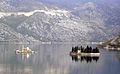
Saint-George and Our-Lady-of-the-Reef, two islands off Perast.

Church in Perast.
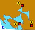
Bay of Kotor and Illyrian fortresses on the hills 1)Risan 2)Gosici 3)Kremalj (Mirac)

Kotor bay from St John Castle.
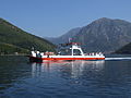
Ferry to village Kamenari

The ancient fortifications of Kotor
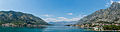
Panorama of the Bay of Kotor


Literature
- Odjeci slavnih vremena – Tomislav Grgurević,
- Boka kotorska: Etnički sastav u razdoblju austrijske uprave (1814.-1918. g.),Ivan Crkvenčić, Antun Schaller, Hrvatski geografski glasnik 68/1, 51–72 (2006),
See also
- Albania Veneta
- Crazy Vuk's border
- Croatian Civic Society of Montenegro
- Montenegrin Littoral
- Prevlaka
References
^ D Magaš. Natural-Geographic Characteristics of the Boka Kotosdka Area As the Basis of Development. Geoadria Vol. 7 No. 1, Croatian Geographical Society and University of Zadar Department of Geography, Zadar, 2002, pp. 53.
^ "Late Holocene Glacial History of Sólheimajökull, Southern Iceland" (PDF). Archived from the original (PDF) on 2014-03-20..mw-parser-output cite.citation{font-style:inherit}.mw-parser-output q{quotes:"""""""'""'"}.mw-parser-output code.cs1-code{color:inherit;background:inherit;border:inherit;padding:inherit}.mw-parser-output .cs1-lock-free a{background:url("//upload.wikimedia.org/wikipedia/commons/thumb/6/65/Lock-green.svg/9px-Lock-green.svg.png")no-repeat;background-position:right .1em center}.mw-parser-output .cs1-lock-limited a,.mw-parser-output .cs1-lock-registration a{background:url("//upload.wikimedia.org/wikipedia/commons/thumb/d/d6/Lock-gray-alt-2.svg/9px-Lock-gray-alt-2.svg.png")no-repeat;background-position:right .1em center}.mw-parser-output .cs1-lock-subscription a{background:url("//upload.wikimedia.org/wikipedia/commons/thumb/a/aa/Lock-red-alt-2.svg/9px-Lock-red-alt-2.svg.png")no-repeat;background-position:right .1em center}.mw-parser-output .cs1-subscription,.mw-parser-output .cs1-registration{color:#555}.mw-parser-output .cs1-subscription span,.mw-parser-output .cs1-registration span{border-bottom:1px dotted;cursor:help}.mw-parser-output .cs1-hidden-error{display:none;font-size:100%}.mw-parser-output .cs1-visible-error{font-size:100%}.mw-parser-output .cs1-subscription,.mw-parser-output .cs1-registration,.mw-parser-output .cs1-format{font-size:95%}.mw-parser-output .cs1-kern-left,.mw-parser-output .cs1-kern-wl-left{padding-left:0.2em}.mw-parser-output .cs1-kern-right,.mw-parser-output .cs1-kern-wl-right{padding-right:0.2em}
^ Hupchick, Dennis P. The Balkans: From Constantinople to Communism. Palgrave Macmillan, 2004.
ISBN 1-4039-6417-3
^ Rastko.org, Arheologija 13047
^ J B Bury, History of the Later Roman Empire from Arcadius to Irene, Vol 2 L
^ Serbian studies, Volumes 2–3, p. 29
^ De originibus Slavicis, Volume 1 By Johann Christoph von Jordan, p. 155
^ Rick Steves Snapshot Dubrovnik by Rick Steves and Cameron Hewitt
^ Miloš Milošević (1988). Hajduci u Boki Kotorskoj 1648–1718. CANU.
^ Marko Jačov (1992). Le Missioni cattoliche nei Balcani durante la Guerra di Candia (1645–1669). Biblioteca apostolica vaticana. pp. 709–. ISBN 978-88-210-0638-8.
^ "[Projekat Rastko – Boka] Simo Matavulj – Boka i Bokelji". rastko.org.rs. Archived from the original on 24 September 2015. Retrieved 31 May 2015.
^ http://www.monstat.org/EngPOPIS1.htm. Retrieved October 11, 2010. Missing or empty|title=(help)
[dead link]
^ "Slavni "Kapetani Boke kotorske"". Radio DUX. Retrieved 31 May 2015.
^ Petar Želalić famous naval captain, from Boka Kotorska Archived April 22, 2014, at the Wayback Machine.
External links
| Wikimedia Commons has media related to Bay of Kotor. |
Coordinates: 42°26′N 18°38′E / 42.433°N 18.633°E / 42.433; 18.633
Regions in Montenegro | ||
|---|---|---|
|  | |


