Cumberland, Maryland
| Cumberland, Maryland | ||
|---|---|---|
| City | ||
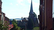
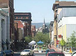 Downtown Cumberland in July 2001 | ||
| ||
| Nickname(s): "Queen City", "C-Land" | ||
| Motto(s): "Come for a Visit, Stay for Life!" | ||
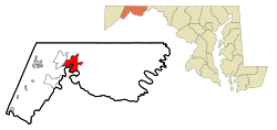 Location in Allegany County and in Maryland | ||
 Cumberland Location within the state of Maryland Show map of Maryland  Cumberland Cumberland (the US) Show map of the US | ||
| Coordinates: 39°38′52″N 78°45′46″W / 39.64778°N 78.76278°W / 39.64778; -78.76278Coordinates: 39°38′52″N 78°45′46″W / 39.64778°N 78.76278°W / 39.64778; -78.76278 | ||
| Country | ||
| State | ||
| County | ||
| Founded | 1787 | |
| Incorporated | 1815 | |
| Government | ||
| • Type | Council-CEO | |
| • Mayor | Brian K. Grim (D) | |
| • City administrator | Jeff Rhodes as of December 20, 2011 | |
| • City Council | Seth D. Bernard (D) Richard J. Cioni (D) Eugene T. Frazier (D) David Caporale (R) | |
| Area[1] | ||
| • City | 10.15 sq mi (26.29 km2) | |
| • Land | 10.08 sq mi (26.11 km2) | |
| • Water | 0.07 sq mi (0.18 km2) | |
| Elevation | 627 ft (191 m) | |
| Population (2010)[2] | ||
| • City | 20,859 | |
| • Estimate (2016)[3] | 19,978 | |
| • Density | 2,100/sq mi (790/km2) | |
| • Metro | 103,299 | |
| • Demonym | Cumberlander | |
| Time zone | UTC−5 (Eastern (EST)) | |
| • Summer (DST) | UTC−4 (EDT) | |
| ZIP codes | 21501-21505 | |
| Area code(s) | 301, 240 | |
| FIPS code | 24-21325 | |
GNIS feature ID | 0590057 | |
| Website | www.ci.cumberland.md.us | |

Cumberland is a city in and the county seat of Allegany County, Maryland, United States. It is the primary city of the Cumberland, MD-WV Metropolitan Statistical Area. At the 2010 census, the city had a population of 20,859, and the metropolitan area had a population of 103,299. Cumberland is a regional business and commercial center for Western Maryland and the Potomac Highlands of West Virginia.
Historically Cumberland was known as the "Queen City," as it was once the second largest in the state. Because of its strategic location on what became known as the Cumberland Road through the Appalachians, after the American Revolution it served as a historical outfitting and staging point for westward emigrant trail migrations throughout the first half of the 1800s. In this role, it supported the settlement of the Ohio Country and the lands in that latitude of the Louisiana Purchase. It also became an industrial center, served by major roads, a canal connecting to Washington, DC, and railroads.
Industry declined after World War II. Much of the later urban, business and technological development in the state has been concentrated in eastern coastal cities. Today the Cumberland, MD-WV Metropolitan Statistical Area is one of the poorest in the United States, ranking 305th out of 318 metropolitan areas in per capita income.[4]
Contents
1 History
2 Geography
2.1 Cumberland Narrows
2.2 Climate
3 Demographics
3.1 2010 census
4 Tourism in Cumberland, Maryland
4.1 Western Maryland Railway Station
4.2 Arts & Entertainment District
4.3 Canal Place Heritage Area
4.4 The Great Allegheny Passage
4.5 Rocky Gap Casino Resort and State Park
4.6 Allegany Museum
4.7 The Narrows and Lovers Leap
4.8 Other attractions
4.9 Nearby attractions and points of interest
5 Notable landmarks
6 Education
7 Utilities
8 Transportation
9 Media
10 Notable people
11 In popular culture
12 Sister cities
13 See also
14 References
15 External links
History
Cumberland was named by English colonists after the son of King George II, Prince William, the Duke of Cumberland. It is built on the site of the mid-18th century Fort Cumberland, the starting point for British General Edward Braddock's ill-fated attack on the French stronghold of Fort Duquesne (present-day Pittsburgh) during the French and Indian War, the North American front of the Seven Years' War between the French and the British. (See Braddock expedition.) This area had long been settled for thousands of years by indigenous peoples. The fort was developed along the Great Indian Warpath which tribes used to travel the backcountry.
Cumberland also served as an outpost of Colonel George Washington during the French and Indian War, and his first military headquarters was built here. Washington returned as President of the United States in 1794 to Cumberland to review troops assembled to thwart the Whiskey Rebellion.

Map of Braddock's Military Road
During the 19th century, Cumberland was a key road, railroad and canal junction. It became the second-largest city in Maryland after the port city of Baltimore. It was nicknamed "The Queen City".[5] Cumberland was the terminus, and namesake, of the Cumberland Road (begun in 1811) that extended westward to the Ohio River at Wheeling, West Virginia. This was the first portion of what would be constructed as the National Road, which eventually reached Ohio, Indiana, and Illinois.[5]
The surrounding hillsides were mined for coal and iron ore, and harvested for timber that helped supply the Industrial Revolution. The Chesapeake and Ohio Canal had its western terminus here; it was built to improve the movement of goods between the Midwest and Washington, DC, the eastern terminus. Construction of railroads superseded use of the canal, as trains were faster and could carry more freight. The city developed as a major manufacturing center, with industries in glass, breweries, fabrics and tinplate.
With the restructuring of heavy industry in the Northeast and Mid-Atlantic states following World War II, the city lost many jobs. As a result, its population has declined by nearly half, from 39,483 in the 1940 census to fewer than 20,000 today.[6][7]
Geography
Cumberland is in the Ridge and Valley physiographic province of the Appalachian Mountains at 39°38′52″N 78°45′46″W / 39.647687°N 78.762869°W / 39.647687; -78.762869 (39.647687, −78.762869),[8] at the junction of the North Branch of the Potomac River and Wills Creek. The majority of the land within the city lies in a valley created by the junction of these two streams. Interstate 68 runs through the city in an east/west direction, as does Alternate U.S. 40, the Old National Road. U.S. Highway 220 runs north/south. Parts of Wills Mountain, Haystack Mountain, and Shriver Ridge are also within the city limits.
Terminus of the Chesapeake and Ohio Canal in Cumberland. Highway bridge is Interstate 68. Canal Place Museum is the brick building behind bridge.
The abandoned Chesapeake and Ohio Canal is now part of the Chesapeake and Ohio Canal National Historical Park.[5] The canal's towpath is maintained, allowing travel by foot, horse or bicycle between Cumberland and Washington, D.C., a distance of about 185 miles (298 km). In recent years a separate trail/path extension, called the Great Allegheny Passage, has been developed that leads to Pittsburgh as its western terminus. Cumberland is the only city of at least 20,000 residents, outside of the Pittsburgh and DC metro areas, that lies on this combined 300+ mile stretch.
According to the United States Census Bureau, the city has a total area of 10.15 square miles (26.29 km2), of which 10.08 square miles (26.11 km2) is land and 0.07 square miles (0.18 km2) is water.[1]
Cumberland Narrows

The Cumberland Narrows west of Cumberland, Maryland, along Wills Creek, with Haystack Mountain on the left and Wills Mountain on the right. The easy crossing of the rugged Wills Mountain Anticline through this water gap is used by the Western Maryland Scenic Railroad (left), the Old National Road (Alternate U.S. 40) (center, left of the creek), and the CSX Railroad (right).
Cumberland is at the eastern entrance to the Cumberland Narrows (or "The Narrows"), a water gap along Wills Creek that crosses the central ridge of the Wills Mountain Anticline at a low elevation between Wills Mountain to the north and Haystack Mountain to the south. Cliffs and talus of the two mountains' Tuscarora quartzite caprock are prominent within the Narrows. These geological features provide Cumberland a western backdrop of the two mountains and the narrow gap between them.
The Cumberland Narrows acts as a western gateway from Cumberland to the Appalachian Plateau and the Ohio River Valley beyond. The Old National Road, now Alternate U.S. 40, passes through the Narrows. The former Baltimore and Ohio Railroad's main line between Baltimore/Washington and Pittsburgh, now part of the CSX system, and a former line of the Western Maryland Railroad, now used by the steam- and diesel-powered excursion trains of the Western Maryland Scenic Railroad, also use this route.
A prominent rocky outcropping at the south end of Wills Mountain in the Cumberland Narrows is known as Lover's Leap.
Climate
Cumberland lies at the beginning of the transition from a humid continental climate (Köppen Dfa) to a humid subtropical climate (Cfa), although bearing far more characteristics of the former, with a range of temperatures significantly lower than those in the central and eastern part of Maryland, mostly in the form of depressed nighttime lows. Cumberland is the only major city in Maryland to fall within the humid continental (Dfa) climate. Hagerstown lies in the middle of the transition zone.
The region has four distinct seasons, with hot, humid summers, and moderate winters (compared to surrounding communities, Cumberland receives milder winters and less snow). Monthly daily mean temperatures range from 31.9 °F (−0.1 °C) in January to 76.8 °F (24.9 °C) in July, with temperatures exceeding 90 °F (32 °C) on 34.5 days of the year and dipping to 10 °F (−12 °C) or below on 7 nights per winter. Average seasonal snowfall totals 30.3 inches (77 cm). The record high is 109 °F (43 °C) set in July 1936 and August 1918, both of which are state record highs, while the record low is −17 °F (−27 °C) set in February 1899.[citation needed]
| Climate data for Cumberland, Maryland (1981−2010 normals, extremes 1974−present) | |||||||||||||
|---|---|---|---|---|---|---|---|---|---|---|---|---|---|
| Month | Jan | Feb | Mar | Apr | May | Jun | Jul | Aug | Sep | Oct | Nov | Dec | Year |
| Record high °F (°C) | 75 (24) | 79 (26) | 90 (32) | 96 (36) | 98 (37) | 103 (39) | 105 (41) | 105 (41) | 102 (39) | 93 (34) | 87 (31) | 80 (27) | 105 (41) |
| Average high °F (°C) | 41.4 (5.2) | 45.6 (7.6) | 55.8 (13.2) | 68.0 (20) | 76.5 (24.7) | 84.7 (29.3) | 88.7 (31.5) | 87.5 (30.8) | 80.0 (26.7) | 69.0 (20.6) | 56.6 (13.7) | 44.7 (7.1) | 66.6 (19.2) |
| Average low °F (°C) | 22.4 (−5.3) | 23.9 (−4.5) | 31.6 (−0.2) | 41.1 (5.1) | 51.1 (10.6) | 60.4 (15.8) | 64.8 (18.2) | 63.3 (17.4) | 54.8 (12.7) | 43.0 (6.1) | 34.2 (1.2) | 26.5 (−3.1) | 43.2 (6.2) |
| Record low °F (°C) | −14 (−26) | −3 (−19) | 3 (−16) | 20 (−7) | 25 (−4) | 39 (4) | 46 (8) | 38 (3) | 31 (−1) | 20 (−7) | 10 (−12) | −8 (−22) | −14 (−26) |
| Average precipitation inches (mm) | 2.66 (67.6) | 2.37 (60.2) | 3.37 (85.6) | 3.30 (83.8) | 4.02 (102.1) | 3.28 (83.3) | 3.56 (90.4) | 3.17 (80.5) | 3.23 (82) | 2.57 (65.3) | 2.98 (75.7) | 2.85 (72.4) | 37.36 (948.9) |
| Average snowfall inches (cm) | 8.7 (22.1) | 7.8 (19.8) | 6.0 (15.2) | 0.2 (0.5) | 0 (0) | 0 (0) | 0 (0) | 0 (0) | 0 (0) | 0 (0) | 0.6 (1.5) | 5.6 (14.2) | 28.9 (73.3) |
| Average precipitation days (≥ 0.01 in) | 11.6 | 9.9 | 11.2 | 11.6 | 13.3 | 11.1 | 10.6 | 9.5 | 9.2 | 8.6 | 9.6 | 10.6 | 126.8 |
| Average snowy days (≥ 0.1 in) | 3.7 | 3.1 | 2.0 | 0.1 | 0 | 0 | 0 | 0 | 0 | 0 | 0.4 | 1.9 | 11.2 |
| Source: NOAA[9][10] | |||||||||||||
Demographics
| Historical population | |||
|---|---|---|---|
| Census | Pop. | %± | |
| 1840 | 2,428 | — | |
| 1850 | 6,073 | 150.1% | |
| 1860 | 4,078 | −32.9% | |
| 1870 | 8,056 | 97.5% | |
| 1880 | 10,693 | 32.7% | |
| 1890 | 12,729 | 19.0% | |
| 1900 | 17,128 | 34.6% | |
| 1910 | 21,839 | 27.5% | |
| 1920 | 29,837 | 36.6% | |
| 1930 | 37,747 | 26.5% | |
| 1940 | 39,483 | 4.6% | |
| 1950 | 37,679 | −4.6% | |
| 1960 | 33,415 | −11.3% | |
| 1970 | 29,724 | −11.0% | |
| 1980 | 25,933 | −12.8% | |
| 1990 | 23,706 | −8.6% | |
| 2000 | 21,518 | −9.2% | |
| 2010 | 20,859 | −3.1% | |
| Est. 2016 | 19,978 | [3] | −4.2% |
| U.S. Decennial Census[11] | |||
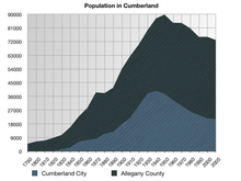
A graph showing the population in Cumberland and Allegany County
The median household income $25,142, and the median family income was $34,500. Males had a median income of $29,484 versus $20,004 for females. The per capita income for the city was $15,813. About 15.3% of families and 19.8% of the population were below the poverty line, including 29.4% of those under age 18 and 10.3% of those age 65 or over. The Cumberland, MD-WV Metropolitan Statistical Area ranked 305th out of 318 metropolitan areas in per capita income.[4]
In 2007, Forbes ranked the Cumberland Metro as having the 6th-lowest cost of living in the USA, based on an index of cost of housing, utilities, transportation and other expenditures.[12]
In 2007, The Baltimore Sun newspaper, citing the National Association of Realtors figures on home prices, stated that while most areas were stagnant, Cumberland home prices were rising by more than 17%, the highest in the country.[13] In July 2007, Washington Post writer Stephanie Cavanaugh wrote that the great quality of living in Cumberland had attracted many urbanites to the area.[14]
Population trends
Population decline from 1950–1990 was due to a string of industrial plant closures. Plants such as Pittsburgh Plate Glass, Allegany Munitions and Celanese closed down and relocated as part of widespread industrial restructuring after WWII. The 1987 closure of the Kelly Springfield Tire Plant marked a turning point, as it was the last major manufacturing plant in the city limits to close its doors.
The population of the city has continued to decline since 1990, with the 2010 census population of 20,859 the lowest since the 1900 census.
2010 census
As of the census[2] of 2010, there were 20,859 people, 9,223 households, and 4,982 families residing in the city. The population density was 2,069.3 inhabitants per square mile (799.0/km2). There were 10,914 housing units at an average density of 1,082.7 per square mile (418.0/km2). The racial makeup of the city was 89.4% White, 6.4% African American, 0.2% Native American, 0.9% Asian, 0.1% Pacific Islander, 0.3% from other races, and 2.8% from two or more races. Hispanic or Latino people of any race were 1.2% of the population.
There were 9,223 households of which 25.9% had children under the age of 18 living with them, 34.0% were married couples living together, 15.1% had a female householder with no husband present, 4.9% had a male householder with no wife present, and 46.0% were non-families. 38.9% of all households were made up of individuals and 18.1% had someone living alone who was 65 years of age or older. The average household size was 2.19 and the average family size was 2.89.
The median age in the city was 41.4 years. 20.9% of residents were under the age of 18; 10.2% were between the ages of 18 and 24; 23.1% were from 25 to 44; 26.2% were from 45 to 64; and 19.6% were 65 years of age or older. The gender makeup of the city was 47.0% male and 53.0% female.
Tourism in Cumberland, Maryland

Downtown Cumberland, Maryland
The Downtown Cumberland Historic District is an attraction for locals and tourists alike. The heart of the downtown area is Baltimore Street. Formerly the main thoroughfare through the city, Baltimore Street is now a brick pedestrian mall. The street is lined with large multi-story commercial buildings, most of which were built in the late 19th and early 20th centuries. These buildings, which were formerly banks, hotels, and department stores, are relics of the city's former wealth and importance during the industrial age. They now contain more tourist oriented businesses such as sidewalk cafes, antique stores, boutiques and art galleries. Baltimore Street hosts some of the city's biggest sidewalk festivals and block parties.
Western Maryland Railway Station
A block west of the downtown pedestrian mall is the Western Maryland Railway Station. This early 20th-century train station is home to the Western Maryland Scenic Railroad, known regionally as "Mountain Thunder". The Western Maryland Scenic Railroad offers three hour round trip tours from Cumberland to Frostburg using restored 1916 Baldwin Steam Locomotive Number 734 or "Mountain Thunder" (Currently out of service). The Western Maryland Railway Station is part of the.[15] Canal Place Heritage Area, the first in the state of Maryland.
Arts & Entertainment District
Downtown Cumberland's Arts & Entertainment District is home to the Allegany Arts Council and its Saville Gallery, the Allegany Museum, the Cumberland Theatre, the Arts at Canal Place Cooperative Gallery, the New Embassy Theatre, the Cumberland Music Academy, MettleArts Studio & Foundry, the Arteco Gallery and Institute for Creative Enterprise, Windsor Hall (a multi-purpose performance venue), the Gilchrist Museum of the Arts, the Gordon-Roberts House, the Graphicus Atelier print-making studio, and a variety of retail and specialty stores. Seasonal events include the Cumberland Comes Alive music series, Saturday Arts Walks, and the annual Mountain Maryland Artists’ Studio Tour.[16][not specific enough to verify]
Canal Place Heritage Area

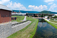
C&O Canal at Swain's Lock
Canal Place is located at the western terminus of the C&O Canal. A national park has been created in the city center at the intersection of the railroad, C&O Canal, and Allegheny Highlands Trail of Maryland at Canal Place. While at the Heritage Area, visitors can ride the Western Maryland Scenic Railroad, tour a full-scale replica canal boat, visit the C&O Canal National Historical Park Cumberland Visitor Center, get information about attractions and events in Allegany County, hike or bike ride on the canal towpath, or attend unique festivals and events like C&O CanalFest. A re-watering project is underway which when completed will allow visitors to ride in replica canal boats through a portion of the old canal.
The Chesapeake and Ohio Canal National Historical Park is 184.5 miles (296.9 km) following the Potomac River from Georgetown in Washington, D.C. to Cumberland. Its towpath is popular with runners, hikers, and bicyclists. There are campsites approximately every five miles along the trail.
The Great Allegheny Passage
The C&O Canal has its Western Terminus at Canal Place, and it is possible to travel by foot or bicycle from here to Washington, D.C. along the canal towpath - a distance of roughly 185 miles (298 km). The Allegheny Highlands Trail of Maryland is a 21-mile (34 km) section of an expansive hiking/biking trail starting in Pittsburgh and ending in Cumberland where it connects with the C&O Canal towpath and onto Washington DC. Together, the C&O Canal towpath and the Allegheny Highlands Trails are part of the 315 Mile Great Allegheny Passage.
Rocky Gap Casino Resort and State Park
Just outside Cumberland, the Rocky Gap Lodge and Golf Resort sits in the valley between Evitt's Mountain and Martin's Mountain. The resort is located on the shore of the 243-acre (0.98 km2) Lake Habeeb in Rocky Gap State Park, and boasts Maryland's only Jack Nicklaus Signature Golf Course.
Allegany Museum
Located on the Downtown Cumberland Pedestrian Mall, the Allegany Museum exhibits the local history and architecture of the Allegany region and Cumberland area. Some of the exhibits include: The history and architecture of Allegany County, the history of Kelly Springfield Tire Company, MeadWestvaco, prehistoric life, the Cumberland glassware industry, fire prevention, folk art, the Cumberland brewing industry, and more. It is open from May to December.[17][not specific enough to verify]
The Narrows and Lovers Leap
The Narrows is a compact notched valley that Wills Creek has carved into Wills Mountain. Inventor Frederick John Bahr bought Wills Mountain and built his log cabin on top.
The National Road (U.S. Route 40) and a number of railroad lines pass through this steep, narrow, and rocky river valley on the edge of Cumberland. On the northeast side of Wills Mountain, sits a rocky outcropping known as Lover's Leap. The name comes from a Native American Romeo and Juliet legend. The tale tells how a jilted lover met his end by jumping off this ledge. Today, the rocks high above the water provide extensive views of the Allegheny Mountains. Lover's Leap has been frequently romanticized by postcard pictures of this valley, including those taken by George Steward in 1950 and published in the 1953 book U.S. 40.
Lover's Leap is 1,652 feet (504 m) above sea level and made up of oddly squared projectories of rock, from its top, all the way down to the National Highway (U.S. Rte. 40) below. The City of Cumberland and the neighboring states of Pennsylvania and West Virginia may be seen from this point.
Other attractions
- Constitution Park
Cumberland Theatre Company, located on N. Johnson St., offering year-round performances- Gene Mason Sports Complex
- New Embassy Theater
Nearby attractions and points of interest
- The Thrasher Carriage Museum, in Frostburg, Maryland, has one of the nation's top collections of horse-drawn vehicles, representing every walk of life, from the milkman to the wealthy. Pleasure vehicles, funeral wagons, sleighs, carts, and more are on display in the renovated 19th-century warehouse. Housed in a renovated warehouse opposite the steam train depot in Frostburg, this museum houses an extensive collection of late 19th- and early 20th-century horse-drawn carriages, featuring more than 50 vehicles from the collection of the late James R. Thrasher. Highlights include the inaugural coach used by Teddy Roosevelt, several Vanderbilt sleighs, elaborately decorated funeral wagons, formal closed vehicles, surreys, and open sleighs.
- The Paw Paw Tunnel is one of the world's longest canal tunnels and was one of the greatest engineering feats of its day.
- The Sideling Hill road cut is a 340-foot (100 m) deep road cut where Interstate 68 cuts through Sideling Hill. It is notable as an impressive man-made mountain pass, visible from miles away and one of the best rock exposures in Maryland and indeed in the entire northeastern United States. Almost 810 feet (250 m) of strata in a tightly folded syncline are exposed in this road cut.
- Dan's Mountain State Park
Notable landmarks

Allegany County Courthouse

Wills Creek
Downtown Cumberland
Some of Cumberland's most architecturally significant homes are located in the Washington Street Historic District. Considered the elite residential area when the city was at its economic peak, Washington Street was home to the region's leading citizens including the president of the C&O Canal. Significant public buildings include the Allegany County Courthouse, Allegany County Library, and Emmanuel Episcopal Church, located on the site of Fort Cumberland. It features Gothic Revival architecture with three large Tiffany windows, fort tunnels, and ammunition magazine cellars.[18]
The 1850 Emmanuel Episcopal Church, standing at the eastern end of the Washington Street Historic District, is one of Maryland's most outstanding examples of early Gothic Revival architecture. The Allegany County Courthouse dominates the city's skyline. It was designed in 1893 by local architect Wright Butler. The Queen City Hotel was built by the B&O during the 1870s. The battle to preserve it was lost when the building was demolished in 1972. Temple B'er Chayim's 1865 Gothic Revival building is one of the oldest surviving synagogue buildings in the United States.
Also of note are the Western Maryland Scenic Railroad, the Chesapeake and Ohio Canal National Historical Park Terminus at Canal Place, the Chesapeake and Ohio Canal National Historical Park, the Allegheny Highlands Trail of Maryland, the Allegany Arts Council, Rocky Gap State Park, Cumberland Narrows along Wills Creek, on Alternate U.S. 40.
Education
The offices of Allegany County Public Schools are located in Cumberland. The city is served by
Allegany High School and Fort Hill High School, the private Bishop Walsh School, The Center for Career and Technical Education of Allegany County, and Calvary Christian Academy, and elementary schools such as Cresaptown Elementary School, South Penn Elementary School, Northeast Elementary School, John Humbird, and Cash Valley Elementary School.
Approximately 39,000 people hold library cards in Allegany County, with libraries such as Washington Street Library and Lavale Public Library and several others.
Utilities
Water and sewer service is supplied by the City of Cumberland. The municipal watershed is located to the north within the Commonwealth of Pennsylvania. Water is drawn from two lakes on city land, Gordon and Koon. Electricity service is supplied by the Potomac Edison Company, which is a unit of FirstEnergy, while natural gas service is supplied by Columbia Gas of Maryland. There was once a working oil well that pumped crude oil from a location near the Fruit Bowl in the Cumberland Narrows.
Hospitals include Western Maryland Regional Medical Center and Thomas B. Finan Center.
Transportation
The primary public transportation in the City of Cumberland is bus service provided by Allegany County Transit. This service consists of five scheduled routes that reach most areas of the City and provide access to most public facilities. Major highway arteries serving the Cumberland area include Interstate 68, U.S. Route 40 and U.S. Route 220.
Amtrak, the national passenger rail system, provides intercity service to Cumberland via the Capitol Limited, which runs between Washington, D.C., and Chicago, Illinois. The Cumberland Amtrak Station is located downtown at Queen City Drive and East Harrison Street. The Western Maryland Scenic Railroad operates steam and diesel excursion trains from Cumberland to Frostburg and back. CSX had a large hump yard for full service to Pittsburgh over Sand patch grade to the west, the Grafton, West Virginia, line to the south, & the Baltimore, Maryland, line to the east. The Greater Cumberland Regional Airport (Airport-ID: CBE) provides local air transportation to the Cumberland area, located in West Virginia, to the south of the Potomac River. Mexico Farms Airport (Airport-ID: 1W3) is also in Cumberland.
Media
Cumberland has several media outlets; most carry some form of satellite programming. WCBC-AM and WFRB-FM have some local news content, but do not have reporters collecting it. The closest public radio station is WFWM, at Frostburg, Maryland. Allegany Magazine is a recent media addition. The Cumberland Times-News is the area's daily newspaper.
Notable people
In popular culture
The webcomic The Adventures of Dr. McNinja by Christopher Hastings is set in part in a fictionalized version of Cumberland.[19]
Sister cities
 Tapa, Lääne-Viru County, Estonia
Viljandi, Estonia[20]
See also
 Cumberland, Maryland portal
- Tourism in Cumberland, Maryland
- List of festivals and events in Cumberland, MD-WV
- Federal Correctional Institution, Cumberland
References
^ ab "US Gazetteer files 2010". United States Census Bureau. Archived from the original on 2012-01-24. Retrieved 2013-01-25..mw-parser-output cite.citation{font-style:inherit}.mw-parser-output q{quotes:"""""""'""'"}.mw-parser-output code.cs1-code{color:inherit;background:inherit;border:inherit;padding:inherit}.mw-parser-output .cs1-lock-free a{background:url("//upload.wikimedia.org/wikipedia/commons/thumb/6/65/Lock-green.svg/9px-Lock-green.svg.png")no-repeat;background-position:right .1em center}.mw-parser-output .cs1-lock-limited a,.mw-parser-output .cs1-lock-registration a{background:url("//upload.wikimedia.org/wikipedia/commons/thumb/d/d6/Lock-gray-alt-2.svg/9px-Lock-gray-alt-2.svg.png")no-repeat;background-position:right .1em center}.mw-parser-output .cs1-lock-subscription a{background:url("//upload.wikimedia.org/wikipedia/commons/thumb/a/aa/Lock-red-alt-2.svg/9px-Lock-red-alt-2.svg.png")no-repeat;background-position:right .1em center}.mw-parser-output .cs1-subscription,.mw-parser-output .cs1-registration{color:#555}.mw-parser-output .cs1-subscription span,.mw-parser-output .cs1-registration span{border-bottom:1px dotted;cursor:help}.mw-parser-output .cs1-hidden-error{display:none;font-size:100%}.mw-parser-output .cs1-visible-error{font-size:100%}.mw-parser-output .cs1-subscription,.mw-parser-output .cs1-registration,.mw-parser-output .cs1-format{font-size:95%}.mw-parser-output .cs1-kern-left,.mw-parser-output .cs1-kern-wl-left{padding-left:0.2em}.mw-parser-output .cs1-kern-right,.mw-parser-output .cs1-kern-wl-right{padding-right:0.2em}
^ ab "American FactFinder". United States Census Bureau. Retrieved 2013-01-25.
^ ab "Population and Housing Unit Estimates". Retrieved June 9, 2017.
^ ab Dataplace: Cumberland, MD-WV MAS Archived 2007-09-28 at the Wayback Machine.
^ abc "Bird's Eye View of Cumberland, Maryland 1906". World Digital Library. 1906. Retrieved 2013-07-22.
^ "Cumberland History". National Park Service. Retrieved 19 February 2014.
^ Parts of this article are copied from the Cumberland History, a National Park Service website whose contents are in the public domain.
^ "US Gazetteer files: 2010, 2000, and 1990". United States Census Bureau. 2011-02-12. Retrieved 2011-04-23.
^ "Station Name: MD CUMBERLAND 2". National Oceanic and Atmospheric Administration. Retrieved 2015-05-11.
^
"NowData - NOAA Online Weather Data". National Oceanic and Atmospheric Administration. Retrieved 2015-05-11.
^ "Census of Population and Housing". Census.gov. Archived from the original on May 12, 2015. Retrieved June 4, 2015.
^ "Special Report: Best Places For Business And Careers", Forbes, April 2007.
^ The Baltimore Sun, 29 June 2007
^ Washington Post, Real Estate section, 14 July 2007
^ Canal Place
^ "Downtown Cumberland". downtowncumberland.com.
^ "Allegany Museum – At the Crossroads of American History". www.alleganymuseum.org.
^ Bell, Shannon. "Washington Street Historic District". www.cr.nps.gov.
^ "Dr. McNinja". Cumberland Times-News. June 30, 2008. Retrieved 2014-08-12.
^ "Cumberland Establishes Sister City In Estonia". Cumberland Times-News. June 20, 2013. Retrieved 2013-06-21.
Bibliography
Will H. Lowdermilk, History of Cumberland, first published 1878, reprinted by Clearfield Co., October 1997, Paperback,
ISBN 0-8063-7983-9. Full Text Online
- Amanda Paul, Tom Robertson, Joe Weaver, Cumberland, Arcadia Publishing, Copyright Oct 1, 2003, Paperback,
ISBN 0-7385-1498-5
- Joseph H Weaver, Cumberland, 1787-1987: A Bicentennial History, Published by the City of Cumberland and the Cumberland Bicentennial Committee, January 1, 1987, ASIN B0007165K6
- Mike High, The C&O Canal Companion, Johns Hopkins University Press, 2001,
ISBN 0-8018-6602-2
- Mark D. Sabatke, Discovering The C&O Canal, Schreiber Publishing, 2003,
ISBN 1-887563-67-9
- Allan Powell, Fort Cumberland, Publisher Allan R Powell, 1989,
ISBN 0-9619995-2-7
- Albert L Feldstein, Feldstein's Historic postcard album of Allegany County, Commercial Press Print. Co, 1984, ASIN B0006YQW5C
- Albert L. Feldstein, Feldstein's Historic Coal Mining and Railroads of Allegany County, Maryland, Publisher Albert L Feldstein, 2000,
ISBN 0-9701605-0-X (This book consists of 135 historic Allegany County, Maryland coal mining and railroad-related photographs. These are primarily from the early 20th century. Accompanying each depiction is a historical narrative with facts, figures, dates and other information. Included within this number are 23 biographies of individuals associated with the history of coal mining in the region.) - Albert L. Feldstein, Allegany County (Images of America: Maryland), Arcadia Publishing, 2006,
ISBN 0-7385-4381-0 (features Allegany's towns and communities, downtown business scenes, residential areas, industries, historic buildings, churches, schools, hospitals, floods, parades, coal mining, railroad stations, and historic and natural landmarks. In some cases, the personal messages sent on the back of the postcards are included.)
Census of population and housing (2000): Maryland Summary Social, Economic, and Housing Summary, DIANE Publishing,
ISBN 1-4289-8582-4
- Patrick H. Stakem, 'Cumberland, Then and Now', Arcadia Publishing, 2011,
ISBN 978-0738586984
- James W. Bishop, The Glass Industry of Allegany County, Maryland, 1968, Commercial Press Printing, Cumberland, Maryland.
- Cumberland, A Hometown History, Allegany County High School, Social Studies Department, 2008, Cumberland, Maryland
- J. Thomas Scharf, History of Western Maryland, Vol. 1& 2,
ISBN 0832838764. - Albert L. Feldstein 'Downtown Cumberland 1950-1980," 1994, Cumberland, MD: Commercial Press, ASIN: B000JVCJAO
- Albert Feldstein, The Great Cumberland Floods: Disaster in the Queen City, 2009, The History Press,
ISBN 1596296887
- J. William Hunt, The Story of Cumberland, Maryland, 1965, Allegany County Historical Society, Cumberland, MD
External links
| Wikimedia Commons has media related to Cumberland, Maryland. |
| Look up Cumberland in Wiktionary, the free dictionary. |
 Cumberland, Maryland travel guide from Wikivoyage
 "Cumberland, Md.". The New Student's Reference Work. 1914.
- Cumberland, Maryland municipal government
- Downtown Cumberland, Maryland
- U.S. Geological Survey Geographic Names Information System: Cumberland US Geological Survey
Cumberland, Maryland at Curlie
- History
 | Mount Savage | Ellerslie | Flintstone |
| |||
Frostburg | |||||||
Bel Air | Wiley Ford, West Virginia | Oldtown |
City of Cumberland | ||
|---|---|---|
| Subject areas |
|  |
| Top subjects |
| |
| Neighborhoods |
| |
Municipalities and communities of Allegany County, Maryland, United States | ||
|---|---|---|
County seat: Cumberland | ||
| Cities |
|  |
| Towns |
| |
| CDPs |
| |
| Other communities |
| |
Annapolis (capital) | |
| Topics |
|
| Society |
|
| Regions |
|
| Cities |
|
| Towns |
|
| CDPs |
|
| Counties |
|
| State |
|  |
|---|---|---|
| County departments |
| |
| Municipal departments |
| |
| Sheriff's offices |
| |
| Universities |
| |
Authority control |
|
|---|


