Miyako Islands
| Native name: Miyako-rettō (宮古列島) | |
|---|---|
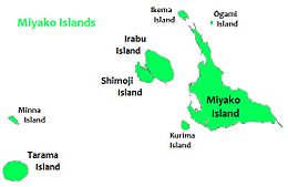 Map of the Miyako Islands | |
| Geography | |
| Location | Pacific Ocean |
| Archipelago | Sakishima Islands |
| Adjacent bodies of water | East China Sea |
| Total islands | 12 |
| Major islands | Miyako Island, Irabu Island, Tarama Island |
| Area | 226.20 km2 (87.34 sq mi) |
| Administration | |
Japan | |
| Prefecture | Okinawa Prefecture |
| Demographics | |
| Population | 55,522 (January 2018) |
| Pop. density | 246.2 /km2 (637.7 /sq mi) |
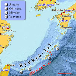
Location of the Miyako Islands

Location of the Miyako Islands in Okinawa Prefecture
The Miyako Islands (宮古列島, Miyako-rettō) are a group of islands in Okinawa Prefecture, Japan, east of the Yaeyama Islands. They are situated between the Ryukyu Islands and Taiwan.
Miyako island has 55,914 people. A bridge connects Miyako Island to Ikema Island, which has 801 people. Tarama village has 1,214 people, between the two islands of Minna and Tarama.
Inhabited islands
 Miyakojima City
Ikema Island (Ikema-jima)
Irabu Island (ja) (Irabu-jima)- Kurima Island (ja) (Kurima-jima)
Miyako Island (ja) (Miyako-jima)- Ōgami Island (ja) (Ōgami-jima)
Shimoji Island (Shimoji-shima)
 Tarama Village (Miyako District)
Minna Island (Minna-jima)- Tarama Island (ja) (Tarama-jima)
See also
- Sakishima Islands
- Miyako language
- Miyako Strait
External links
 Miyako Islands travel guide from Wikivoyage
Coordinates: 24°43′N 125°01′E / 24.717°N 125.017°E / 24.717; 125.017
Authority control |
|
|---|
This Okinawa Prefecture location article is a stub. You can help Wikipedia by expanding it. |


