1964 Alaska earthquake
 Fourth Avenue in Anchorage, Alaska, looking east from near Barrow Street. The southern edge of one of several landslides in Anchorage, this one covered an area of over a dozen blocks, including five blocks along the north side of Fourth Avenue. Most of the area was razed and made an urban renewal district. | |
 | |
UTC time | 1964-03-28 03:36 |
|---|---|
ISC event | 869809 |
| USGS-ANSS | ComCat |
| Local date | March 27, 1964 (1964-03-27) |
| Local time | 17:36:16 AKST |
| Duration | 4–5 minutes. |
| Magnitude | 9.2 Mw,[1] 6.7 mb (ISC) |
| Depth | 25 kilometers (16 mi) |
| Epicenter | 60°54′29″N 147°20′20″W / 60.908°N 147.339°W / 60.908; -147.339 |
| Type | Megathrust |
| Areas affected | United States, Canada |
| Total damage | $311 million (1964 USD) |
| Max. intensity | XI (Extreme) |
| Peak acceleration | 0.18 g |
| Tsunami | Major. Run-up of 67 m (220 ft) at Shoup Bay, Alaska. |
| Casualties | 131 killed |
The 1964 Alaskan earthquake, also known as the Great Alaskan earthquake and Good Friday earthquake, occurred at 5:36 PM AKST on Good Friday, March 27.[2] Across south-central Alaska, ground fissures, collapsing structures, and tsunamis resulting from the earthquake caused about 131 deaths.[3]
Lasting four minutes and thirty-eight seconds, the magnitude 9.2 megathrust earthquake remains the most powerful earthquake recorded in North American history, and the second most powerful earthquake recorded in world history. Six hundred miles (970 km) of fault ruptured at once and moved up to 60 ft (18 m), releasing about 500 years of stress buildup. Soil liquefaction, fissures, landslides, and other ground failures caused major structural damage in several communities and much damage to property. Anchorage sustained great destruction or damage to many inadequately earthquake-engineered houses, buildings, and infrastructure (paved streets, sidewalks, water and sewer mains, electrical systems, and other man-made equipment), particularly in the several landslide zones along Knik Arm. Two hundred miles (320 km) southwest, some areas near Kodiak were permanently raised by 30 feet (9 m). Southeast of Anchorage, areas around the head of Turnagain Arm near Girdwood and Portage dropped as much as 8 feet (2.4 m), requiring reconstruction and fill to raise the Seward Highway above the new high tide mark.
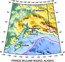
In Prince William Sound, Port Valdez suffered a massive underwater landslide, resulting in the deaths of 32 people between the collapse of the Valdez city harbor and docks, and inside the ship that was docked there at the time. Nearby, a 27-foot (8.2 m) tsunami destroyed the village of Chenega, killing 23 of the 68 people who lived there; survivors out-ran the wave, climbing to high ground. Post-quake tsunamis severely affected Whittier, Seward, Kodiak, and other Alaskan communities, as well as people and property in British Columbia, Washington, Oregon, and California.[4] Tsunamis also caused damage in Hawaii and Japan. Evidence of motion directly related to the earthquake was also reported from Florida and Texas.
Contents
1 Geology
2 Tsunamis
3 Death toll, damage, and casualties
3.1 Anchorage area
3.2 Elsewhere in Alaska
3.3 Canada
3.4 Elsewhere
4 Aftershocks
5 Recovery efforts
6 References
6.1 Specific
6.2 General
7 External links
Geology
On March 27, 1964, at 5:36 p.m. AKST (3:36 a.m. UTC), a fault between the Pacific and North American plates ruptured near College Fjord in Prince William Sound. The epicenter of the earthquake was 12.4 mi (20 km) north of Prince William Sound, 78 miles (125 km) east of Anchorage and 40 miles (64 km) west of Valdez. The focus occurred at a depth of approximately 15.5 mi (25 km). Ocean floor shifts created large tsunamis (up to 220 feet (67 m) in height), which resulted in many of the deaths and much of the property damage.[5] Large rockslides were also caused, resulting in great property damage. Vertical displacement of up to 38 feet (11.5 m) occurred, affecting an area of 100,000 square miles (260,000 km2) within Alaska.
Studies of ground motion have led to a peak ground acceleration estimate of 0.14–0.18 g.[6]
The Alaska earthquake was a subduction zone (megathrust) earthquake, caused by an oceanic plate sinking under a continental plate. The fault responsible was the Aleutian Megathrust, a reverse fault caused by a compressional force. This caused much of the uneven ground which is the result of ground shifted to the opposite elevation. [7]
Tsunamis

Calculated travel time map for the tectonic tsunami produced by the 1964 Prince William Sound earthquake in Alaska. Tsunami Travel Times computed using Tsunami Travel Times[8] software v3.1 (P. Wessel). Map does not show the height or strength of the waves, only the calculated travel times.
Red: 1- to 4-hour arrival times
Yellow: 5- to 6-hour arrival times
Green: 7- to 14-hour arrival times
Blue: 15- to 21-hour arrival times.
Two types of tsunamis were produced by this subduction zone earthquake. There was a tectonic tsunami produced in addition to about 20 smaller and local tsunamis. These smaller tsunamis were produced by submarine and subaerial landslides and were responsible for the majority of the tsunami damage. Tsunami waves were noted in over 20 countries, including Peru, New Zealand, Papua New Guinea, Japan, Mexico, and Antarctica. The largest tsunami wave was recorded in Shoup Bay, Alaska, with a height of about 220 ft (67 m).[3] Tremors were detected in water wells in Australia.[9]
Death toll, damage, and casualties
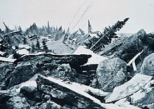
The largest landslide in Anchorage occurred along Knik Arm between Point Woronzof and Fish Creek, causing substantial damage to numerous homes in the Turnagain-By-The-Sea subdivision.

The ruin of Portage

A plank driven through a tire by the tsunami in Whittier

The 5-story JCPenney department store in Anchorage in 1964, following the earthquake.
As a result of the earthquake, 131 people are believed to have died:[3] Nine died as a result of the earthquake itself, 122 died from the subsequent tsunami in places all around the world,[10] five died from the tsunami in Oregon,[11] and 13 died from the tsunami in California.[citation needed] The quake was a reported XI on the modified Mercalli Intensity scale "indicating major structural damage, and ground fissures and failures".[12] Property damage was estimated at about $116 million[3] ($0.70 billion in 2016 dollars).[13] It is likely that the toll would have been much higher had the quake not occurred after 5 PM on Good Friday.[9]
 Play media
United States Geological Survey video explaining the earthquake and footage
Anchorage area
Most damage occurred in Anchorage, 75 mi (120 km) northwest of the epicenter. Anchorage was not hit by tsunamis, but downtown Anchorage was heavily damaged, and parts of the city built on sandy bluffs overlying "Bootlegger Cove clay" near Cook Inlet, most notably the Turnagain neighborhood, suffered landslide damage. The neighborhood lost 75 houses in the landslide, and the destroyed area has since been turned into Earthquake Park. The Government Hill school suffered from the Government Hill landslide, leaving it in two jagged, broken pieces. Land overlooking the Ship Creek valley near the Alaska Railroad yards also slid, destroying many acres of buildings and city blocks in downtown Anchorage. Most other areas of the city were only moderately damaged. The 60-foot (18 m) concrete control tower at Anchorage International Airport was not engineered to withstand earthquake activity and collapsed, killing William George Taylor, the Federal Aviation Agency air traffic controller on duty in the tower cab at the time the earthquake began.[14]
One house on W. 10th Avenue suffered peripheral damage, but only one block away the recently completed (and still unoccupied) Four Seasons Building on Ninth Avenue collapsed completely, with the concrete elevator shafts sticking up out of the rubble like a seesaw.
The hamlets of Girdwood and Portage, located 30 and 40 mi (48 and 64 km) southeast of central Anchorage on the Turnagain Arm, were destroyed by subsidence and subsequent tidal action. Girdwood was relocated inland and Portage was abandoned. About 20 miles (32 km) of the Seward Highway sank below the high-water mark of Turnagain Arm; the highway and its bridges were raised and rebuilt in 1964–66.
Elsewhere in Alaska
Most coastal towns in the Prince William Sound, Kenai Peninsula, and Kodiak Island areas, especially the major ports of Seward, Whittier and Kodiak were heavily damaged by a combination of seismic activity, subsidence, post-quake tsunamis and/or earthquake-caused fires. Valdez was not totally destroyed, but after three years, the town relocated to higher ground four miles (6.4 km) west of its original site. Some Alaska Native villages, including Chenega and Afognak, were destroyed or damaged. The earthquake caused the Cold-War era ballistic missile detection radar of Clear Air Force Station to go offline for six minutes, the only unscheduled interruption in its operational history. Near Cordova, the Million Dollar Bridge crossing the Copper River also collapsed. The community of Girdwood was also confined to the southern side of the Seward Highway when water rushed into Turnagain Arm and flooded or destroyed any buildings left standing to the north of the highway. Only the ground immediately along the highway and that on the north side of the road dropped, prompting geologists to speculate that Girdwood may rest upon an ancient cliff face, now covered by countless thousands of years of sediment and glacial deposits.[citation needed]
Canada
A 4.5 ft (1.4 m) wave reached Prince Rupert, British Columbia, just south of the Alaska Panhandle, about three hours after the earthquake. The tsunami then reached Tofino, on the exposed west coast of Vancouver Island, and traveled up a fjord to hit Port Alberni twice, washing away 55 homes and damaging 375 others. The towns of Hot Springs Cove, Zeballos, and Amai also saw damage.[15] The damage in British Columbia was estimated at CA$10 million ($80 million in 2017 Canadian dollars or $75 million in 2018 US dollars).[16][17][18]
Elsewhere
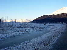
A winter scene of a "ghost forest" that was killed and preserved by salt water along with ruined buildings at the site of the former town of Portage, 2011
Twelve people were killed by the tsunami in or near Crescent City, California, while four children were killed on the Oregon coast at Beverly Beach State Park.[19] Other coastal towns in the U.S. Pacific Northwest and Hawaii were damaged. Minor damage to boats occurred as far south as Los Angeles.[20] Effects of the earthquake were even noted as far east as Freeport, Texas, where tide gauges recorded waves similar to seismic surface waves.[21] Water levels in wells were affected in countries around the world, including England, Namibia, and Australia.[22]
Aftershocks
There were hundreds of aftershocks in the first weeks following the main shock. In the first day alone, eleven major aftershocks were recorded with a magnitude greater than 6.0. Nine more struck over the next three weeks. In all, thousands of aftershocks occurred in the months following the quake, and smaller aftershocks continued to strike the region for more than a year.[20]
Recovery efforts
Alaska had never experienced a major disaster in a highly populated area before, and had very limited resources for dealing with the effects of such an event. In Anchorage, the City of Anchorage and the Alaska State Housing Authority appointed a team of 40 scientists, including geologists, soil scientists, and engineers, to assess the damage done by the earthquake to the city.[23] The team, called the Engineering and Geological Evaluation Group, was headed by Dr. Ruth A. M. Schmidt, a geology professor at the University of Alaska Anchorage. The team of scientists came into conflict with local developers and downtown business owners who wanted to immediately rebuild; the scientists wanted to identify future dangers to ensure that rebuilt infrastructure would be safe.[24] The team produced a report on May 8, 1964, just a little more than a month after the earthquake.[23][25]
The United States military, which has a large active presence in Alaska, also stepped in to assist within moments of the end of the quake. The U.S. Army rapidly re-established communications with the lower 48 states, deployed troops to assist the citizens of Anchorage, and dispatched a convoy to Valdez.[26] On the advice of military and civilian leaders, President Lyndon B. Johnson declared all of Alaska a major disaster area the day after the quake. The U.S. Navy and U.S. Coast Guard deployed ships to isolated coastal communities to assist with immediate needs. Bad weather and poor visibility hampered air rescue and observation efforts the day after the quake, but on Sunday the 29th the situation improved and rescue helicopters and observation aircraft were deployed.[26] A military airlift immediately began shipping relief supplies to Alaska, eventually delivering 2,570,000 pounds (1,170,000 kg) of food and other supplies.[27]
In the longer term, the US Army Corps of Engineers led the effort to rebuild roads, clear debris, and establish new townsites for communities that had been completely destroyed, at a cost of $110 million.[27] The West Coast and Alaska Tsunami Warning Center was formed as a direct response to the disaster. Federal disaster relief funds paid for reconstruction as well as financially supporting the devastated infrastructure of Alaska's government, spending hundreds of millions of dollars that helped keep Alaska financially solvent until the discovery of massive oil deposits at Prudhoe Bay. At the order of the U.S. Defense Department, the Alaska National Guard founded the Alaska Division of Emergency Services to respond to any future disasters.[26]
References
Specific
^ USGS. "M9.2 - The Great Alaska Earthquake and Tsunami of March 27, 1964". United States Geological Survey..mw-parser-output cite.citation{font-style:inherit}.mw-parser-output .citation q{quotes:"""""""'""'"}.mw-parser-output .citation .cs1-lock-free a{background:url("//upload.wikimedia.org/wikipedia/commons/thumb/6/65/Lock-green.svg/9px-Lock-green.svg.png")no-repeat;background-position:right .1em center}.mw-parser-output .citation .cs1-lock-limited a,.mw-parser-output .citation .cs1-lock-registration a{background:url("//upload.wikimedia.org/wikipedia/commons/thumb/d/d6/Lock-gray-alt-2.svg/9px-Lock-gray-alt-2.svg.png")no-repeat;background-position:right .1em center}.mw-parser-output .citation .cs1-lock-subscription a{background:url("//upload.wikimedia.org/wikipedia/commons/thumb/a/aa/Lock-red-alt-2.svg/9px-Lock-red-alt-2.svg.png")no-repeat;background-position:right .1em center}.mw-parser-output .cs1-subscription,.mw-parser-output .cs1-registration{color:#555}.mw-parser-output .cs1-subscription span,.mw-parser-output .cs1-registration span{border-bottom:1px dotted;cursor:help}.mw-parser-output .cs1-ws-icon a{background:url("//upload.wikimedia.org/wikipedia/commons/thumb/4/4c/Wikisource-logo.svg/12px-Wikisource-logo.svg.png")no-repeat;background-position:right .1em center}.mw-parser-output code.cs1-code{color:inherit;background:inherit;border:inherit;padding:inherit}.mw-parser-output .cs1-hidden-error{display:none;font-size:100%}.mw-parser-output .cs1-visible-error{font-size:100%}.mw-parser-output .cs1-maint{display:none;color:#33aa33;margin-left:0.3em}.mw-parser-output .cs1-subscription,.mw-parser-output .cs1-registration,.mw-parser-output .cs1-format{font-size:95%}.mw-parser-output .cs1-kern-left,.mw-parser-output .cs1-kern-wl-left{padding-left:0.2em}.mw-parser-output .cs1-kern-right,.mw-parser-output .cs1-kern-wl-right{padding-right:0.2em}
^ US Geological Survey report on the earthquake Archived 2009-08-25 at the Wayback Machine
^ abcd Tsunami Events Search – sorted by Date, Country, National Geophysical Data Center
^ USC, Tsunami Research Group. "1964 Alaskan Tsunami". University of Southern California. Archived from the original on 8 May 2015. Retrieved 18 July 2015.
^ Historic Earthquakes: Prince William Sound, Alaska Archived 2014-10-11 at the Wayback Machine
^ National Research Council (U.S.). Committee on the Alaska Earthquake, The great Alaska earthquake of 1964, Volume 1, Part 1, National Academies, 1968 p. 285
^ The Great Alaska Earthquake of 1964 and Its Legacy 27 March 2014
^ "Geoware Tsunami Products". www.geoware-online.com. Retrieved 2018-06-21.
^ ab "Getting Ready to Rumble", Richard Conniff, The Wall Street Journal, August 26, 2017.
^ The Great Alaskan Earthquake & Tsunamis of 1964, by the National Oceanic and Atmospheric Administration. Accessed 2009-06-23. Archived 2009-06-25.
^ "Tsunami generated by Good Friday quake devastated Oregon Coast 50 years ago Thursday". OregonLive.com. Retrieved 2018-07-27.
^ ushistory.com: Great Alaskan Quake of 1964 – Retrieved 2014-06-10
^ Thomas, Ryland; Williamson, Samuel H. (2018). "What Was the U.S. GDP Then?". MeasuringWorth. Retrieved January 5, 2018. United States Gross Domestic Product deflator figures follow the Measuring Worth series.
^ Sozen, Mete A. and N. Norby Nielsen, 1973: Analysis of the failure of the Anchorage International Airport control tower. The great Alaska earthquake of 1964, Volume 3, Part 2, National Research Council (U.S.). Committee on the Alaska Earthquake, National Academy of Sciences,
ISBN 0-309-01606-1.
^ "Tsunami runups in Canada in 1964". National Oceanic and Atmospheric Administration.
^ Canadian inflation numbers based on Statistics Canada. "Consumer Price Index, historical summary". Statistics Canada. Retrieved April 26, 2018. CANSIM, table (for fee) 326-0021 and Catalogue nos. 62-001-X, 62-010-X and 62-557-X. And "Consumer Price Index, by province (monthly) (Canada)". Statistics Canada. Retrieved April 26, 2018.
^ Federal Reserve Bank of Minneapolis Community Development Project. "Consumer Price Index (estimate) 1800–". Federal Reserve Bank of Minneapolis. Retrieved January 2, 2019.
^ "A brief history of the Canadian dollar". Retrieved 2018-01-11.
^ Oregon's pioneer spirit. Statesman Journal, December 26, 1999.
^ ab USGS Release: 40th Anniversary of "Good Friday" Earthquake Offers New Opportunities for Public and Building Safety Partnerships (3/26/2004)
^ "Tsunami runups in Freeport". National Oceanic and Atmospheric Administration.
^ Fountain, Henry (2017). The Great Quake: How the biggest earthquake in North America changed our understanding of the planet. New York: Crown. p. 145.
^ ab Friedel, Megan K. (2010). Guide to the Anchorage Engineering Geology Evaluation Group papers, 1964. UAA/APU Consortium Library Archives and Special Collections. HMC-0051. https://archives.consortiumlibrary.org/collections/specialcollections/hmc-0051/
^ "Ruth Anne Marie Schmidt Ph.D." Alaska Women's Hall of Fame. 2015. Retrieved November 23, 2015.
^ Saucier, Heather (April 2014). "PROWESS Honors Historic Earthquake Survivor". American Association of Petroleum Geologists. Retrieved July 31, 2018.
^ abc Cloe, John Haile "Helping Hand" Military response to Good Friday earthquake Alaska Historical Society, 3/4/2014
^ ab Galvin, John Great Alaskan Earthquake and Tsunami: Alaska, March 1964 Popular Mechanics, 6/29/2007
General
.mw-parser-output .refbegin{font-size:90%;margin-bottom:0.5em}.mw-parser-output .refbegin-hanging-indents>ul{list-style-type:none;margin-left:0}.mw-parser-output .refbegin-hanging-indents>ul>li,.mw-parser-output .refbegin-hanging-indents>dl>dd{margin-left:0;padding-left:3.2em;text-indent:-3.2em;list-style:none}.mw-parser-output .refbegin-100{font-size:100%}
National Research Council, Committee On The Alaska Earthquake (1971–73). The Great Alaska Earthquake Of 1964. Washington: National Academy of Sciences.
Geology, Seismology and Geodesy, Hydrology, Biology, Oceanography And Coastal Engineering, Engineering, Human Ecology, Summary and Recommendation
External links
| Wikimedia Commons has media related to Good Friday Earthquake. |
- The Face of Disaster: The Great Alaska Earthquake – US Office of Civil Defense
1964 Good Friday Great Alaskan Earthquake – University of Arizona, Department of Geosciences
1964 Great Alaska Earthquake – United States Geological Survey
The Effects of the March 28, 1964 Alaska Tsunami in British Columbia, Canada – George Pararas-Carayannis
The Great Alaska Earthquake of 1964 – Alaska Earthquake Information Center- The short film ALASKAN EARTHQUAKE (1966) is available for free download at the Internet Archive
Anchorage, AK Good Friday Earthquake, Mar 1964 – GenDisasters.com
Tsunami Anniversary – Oregon Field Guide
Fifty Years Since the Great Alaska Earthquake: The Role of First Responders in Catastrophic Disaster Planning – 113th United States Congress
Tsunami Forecast Model Animation: Alaska 1964 – Pacific Tsunami Warning Center
- The International Seismological Centre has a bibliography and/or authoritative data for this event.
History of Alaska | |||
|---|---|---|---|
 | Timeline of Alaska |
|  |
| Topics and events |
| ||


