Eslamshahr County
Eslamshahr County شهرستان اسلامشهر | |
|---|---|
County | |
 Counties of Tehran Province | |
 Location of Tehran Province in Iran | |
| Coordinates: 35°34′N 51°14′E / 35.567°N 51.233°E / 35.567; 51.233Coordinates: 35°34′N 51°14′E / 35.567°N 51.233°E / 35.567; 51.233 | |
| Country | |
| Province | Tehran |
| Capital | Eslamshahr |
Bakhsh (Districts) | Central District, Chahardangeh District, Ahmadabad-e Mostowfi |
| Area | |
| • Total | 193.0 km2 (74.5 sq mi) |
| Population (20۱۶) | |
| • Total | ۵۴۸۰۰۰ |
| Time zone | UTC+3:30 (IRST) |
| • Summer (DST) | UTC+4:30 (IRDT) |
| Eslamshahr County can be found at GEOnet Names Server, at this link, by opening the Advanced Search box, entering "9206100" in the "Unique Feature Id" form, and clicking on "Search Database". | |
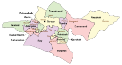
Eslamshahr County (Persian: شهرستان اسلامشهر) is a county in Tehran Province in Iran. The capital of the county is Eslamshahr. At the 2006 census, the county's population was 447,192, in 114,009 families.[1] The county is subdivided into three districts: the Central District/Firuz Bahram, Ahmadabad-e Mostowfi District and Chahardangeh District. The county has three cities: Eslamshahr, Ahmadabad-e Mostowfi and Chahardangeh.


undefined

undefined

undefined


References
^ "Census of the Islamic Republic of Iran, 1385 (2006)". Islamic Republic of Iran. Archived from the original (Excel) on 2011-11-11..mw-parser-output cite.citation{font-style:inherit}.mw-parser-output .citation q{quotes:"""""""'""'"}.mw-parser-output .citation .cs1-lock-free a{background:url("//upload.wikimedia.org/wikipedia/commons/thumb/6/65/Lock-green.svg/9px-Lock-green.svg.png")no-repeat;background-position:right .1em center}.mw-parser-output .citation .cs1-lock-limited a,.mw-parser-output .citation .cs1-lock-registration a{background:url("//upload.wikimedia.org/wikipedia/commons/thumb/d/d6/Lock-gray-alt-2.svg/9px-Lock-gray-alt-2.svg.png")no-repeat;background-position:right .1em center}.mw-parser-output .citation .cs1-lock-subscription a{background:url("//upload.wikimedia.org/wikipedia/commons/thumb/a/aa/Lock-red-alt-2.svg/9px-Lock-red-alt-2.svg.png")no-repeat;background-position:right .1em center}.mw-parser-output .cs1-subscription,.mw-parser-output .cs1-registration{color:#555}.mw-parser-output .cs1-subscription span,.mw-parser-output .cs1-registration span{border-bottom:1px dotted;cursor:help}.mw-parser-output .cs1-ws-icon a{background:url("//upload.wikimedia.org/wikipedia/commons/thumb/4/4c/Wikisource-logo.svg/12px-Wikisource-logo.svg.png")no-repeat;background-position:right .1em center}.mw-parser-output code.cs1-code{color:inherit;background:inherit;border:inherit;padding:inherit}.mw-parser-output .cs1-hidden-error{display:none;font-size:100%}.mw-parser-output .cs1-visible-error{font-size:100%}.mw-parser-output .cs1-maint{display:none;color:#33aa33;margin-left:0.3em}.mw-parser-output .cs1-subscription,.mw-parser-output .cs1-registration,.mw-parser-output .cs1-format{font-size:95%}.mw-parser-output .cs1-kern-left,.mw-parser-output .cs1-kern-wl-left{padding-left:0.2em}.mw-parser-output .cs1-kern-right,.mw-parser-output .cs1-kern-wl-right{padding-right:0.2em}
- اطلس گیتاشناسی استانهای ایران [Atlas Gitashenasi Ostanhai Iran] (Gitashenasi Province Atlas of Iran)
| Capital |
| |||||||||||||||||||||||||||||||||
|---|---|---|---|---|---|---|---|---|---|---|---|---|---|---|---|---|---|---|---|---|---|---|---|---|---|---|---|---|---|---|---|---|---|---|
Counties and cities |
| |||||||||||||||||||||||||||||||||
| Landmarks |
| |||||||||||||||||||||||||||||||||
| Populated places |
| |||||||||||||||||||||||||||||||||
^* indicates that this formerly independent city is now absorbed into Tehran. | ||||||||||||||||||||||||||||||||||

| Capital |
| ||||||||||||||||||||||||||||
|---|---|---|---|---|---|---|---|---|---|---|---|---|---|---|---|---|---|---|---|---|---|---|---|---|---|---|---|---|---|
| Districts |
| ||||||||||||||||||||||||||||
This Eslamshahr County location article is a stub. You can help Wikipedia by expanding it. |


