Ahr
| Ahr | |
|---|---|
 In the valley of the Ahr | |
 The Ahr River | |
| Etymology | Old High German aha ("water") |
| Location | |
| Country | Germany |
| Physical characteristics | |
| Source | |
| - location | Blankenheim, Northern Eifel, North Rhine-Westfalia, Germany |
| - coordinates | 50°26′17″N 7°16′37″E / 50.43806°N 7.27694°E / 50.43806; 7.27694 |
| - elevation | 470 m (1,540 ft) |
| Mouth | Rhine |
Remagen, Rhineland-Palatinate, Germany | |
- coordinates | 50°33′34″N 7°16′37″E / 50.55944°N 7.27694°E / 50.55944; 7.27694Coordinates: 50°33′34″N 7°16′37″E / 50.55944°N 7.27694°E / 50.55944; 7.27694 |
- elevation | 58 m (190 ft) |
| Length | 89 km (55 mi) |
| Basin size | 900 km2 (350 sq mi) |
| Discharge | |
| - average | 8.9 m3/s (310 cu ft/s) |
| Basin features | |
| Progression | Rhine→ North Sea |
Ahr is a river in Germany, a left tributary of the Rhine. Its source is at an elevation of approximately 470 metres (1,540 ft) above sea level in Blankenheim in the Eifel, in the cellar of a timber-frame house near the castle of Blankenheim. After 18 kilometres (11 mi) it crosses from North Rhine-Westphalia into Rhineland-Palatinate.
The Ahr flows through Ahr valley or Ahrtal, passing through the towns of Schuld, Altenahr and Bad Neuenahr-Ahrweiler. Between Remagen and Sinzig (south of Bonn), at about 50 metres (160 ft) above sea level, it flows into the Rhine. The length is roughly 89 kilometres (55 mi), of which 68 kilometres (42 mi) is within Rhineland-Palatinate. The Ahr has a gradient of 0.4 percent in its lower course, and 0.4 to 0.8 percent in its upper course.
Source of Ahr in Blankenheim
The Ahr and its tributaries are a main drainage system of the eastern Eifel. The watershed is approximately 900 square kilometres (350 sq mi).
Contents
1 History
2 Course
3 Tributaries
4 Viticulture
5 See also
6 References
7 External links
History
There were isolated settlements in the Ahr valley beginning at the latest in Roman times, evidenced by the Roman villa near Ahrweiler. Owing to their isolated location, the upper and middle parts of the course were sparsely populated.
That changed from the mid-19th century. The development of the settlements, the traffic routes and the agricultural areas in the Ahr valley led to the fact that the riverbed was fixed.
Course
The Ahr rises in the middle of the village of Blankenheim, in the Eifel region of the German state of North Rhine-Westphalia, in the basement of a timber-framed house in an enclosed spring at a height of 474 m above sea level (NHN). It then flows through the Schwanenweiher pond below Blankenheim Castle.
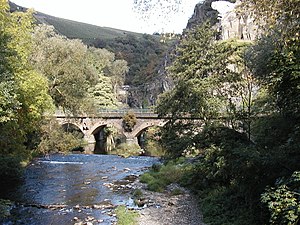
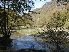
The stream, which runs in a south-easterly direction, through the valley meadows of upper Ahr valley, has not cut very deeply into the heights of the Eifel. Much of the upper Ahr valley is protected and follows the B 258 federal road. Below the hamlet of Ahrdorf in the municipality of Blankenheim, the Ahr reaches its southernmost point and enters the state of Rhineland-Palatine. From Müsch via Antweiler to Fuchshofen, the river runs northwards and turns east at Schuld heading through Insul to Dümpelfeld. Here, the Ahr collects the waters of the Adenauer Bach coming from the right and flowing in a northeasterly direction. In Altenahr, the valley bends to the east and initially follows a very winding course. Here the river is accompanied by the B 267, although it does not follow every loop in the river. In Altenahr, the largest bend in the river beings; it is protected because of its flora and fauna. From here, the valley becomes a gorge bordered by the steep cliffs of the Ahr Hills. From Reimerzhoven the valley sides are dominated by vineyards, especially on the south-facing slopes north of the river, particularly around the villages of Mayschoß, Rech, Dernau and Marienthal. The last narrow point in the Ahr valley occurs below the Bunte Kuh ("coloured cow"), a rock formation that almost reaches the river and leaves little room for road and railway. In Walporzheim, the valley widens abruptly, and the Ahr passes through the county town of Bad Neuenahr. In Heimersheim, the vineyards end. The valley floor between Bad Bodendorf on the northern side and Sinzig on a terrace in the south is dominated by agriculture and fruit and vegetable growing.
The mouth of the Ahr lies on the plain of the Golden Mile, between the Remagen district of Kripp and the town of Sinzig at a height of about 53 m above NHN[1]. Since being re-naturalised (from 1979, see aerial photographs) it has been one of the few natural river mouths on the Rhine and is under protection.[2]
- Ahr - Source, Valley, Mouth

Source of the Ahr (in front of the head) in Blankenheim
The middle Ahr below Altenahr with the rock formation of Langfig

The Ahr by the Bunte Kuh rock formation at Walporzheim

The mouth of the Ahr on the Rhine before re-naturalisation (1957)
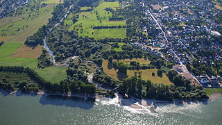
The mouth of the Ahr after re-naturalisation. Right: this village of Kripp


Tributaries
The tributaries of the Ahr include (in upstream order):[3]
| Name | Waterbody No. (GKZ) | Length (km) | Direction | Confluence at km | Place | Remarks |
|---|---|---|---|---|---|---|
| Stegbach | 27181112 | 2.2 | right | 84.9 | Blankenheim | |
Mülheimer Bach | 2718112 | 4.5 | left | 83.1 | ||
Nonnenbach | 271812 | 7.0 | right | 82.5 | ||
Reetzer Bach | 2718132 | 3.6 | left | 80.5 | Reetz | |
Schaafbach | 271814 | 11.4 | right | 79.2 | headstream: Eichholzbach | |
Lampertsbach | 271816 | 9.5 | right | 75.7 | Dollendorf | headstream: Frömmelsbach |
| Fuhrbach | 2718172 | 5.3 | right | 74.6 | Ahrhütte | |
Mühlenbach | 271818 | 7.1 | left | 74.0 | Ahrhütte | headstream: Weilerbach |
Michelsbach | 2718192 | 8.3 | right | 73.2 | ||
| Aulbach | 2718194 | 5.1 | left | 72.9 | ||
| Willemsbach | 27181992 | 1.4 | right | 71.1 | Uedelhoven | |
| Göttersbach | 27181994 | 1.0 | right | 70.7 | Ahrdorf | |
Ahbach | 27182 | 14.9 | right | 68.8 | Ahrdorf | |
Trierbach[4] | 27184 | 25.3 | right | 64.2 | Müsch | |
| Huhnenbach | 271852 | 4.3 | left | 61.1 | Antweiler | |
| Limbach | 2718532 | 3.9 | right | 60.3 | Antweiler | |
Eichenbach | 2718534 | 6.9[4] | left | 58.7 | headstream: Hirzenflosseifen | |
| Laufenbach | 2718536 | 2.8 | right | 55.5 | Fuchshofen | |
Dreisbach | 271854 | 10.0 | left | 55.4 | Fuchshofen | |
Armuthsbach | 271856 | 18.4 | left | 52.0 | Schuld | |
| Holzseifen | 2718574 | 1.0 | left | 47.9 | Schuld | |
| Atzenbach | 2718576 | 2.5 | left | 47.5 | ||
| Lückenbach | 271858 | 5.7 | right | 45.3 | Insul | |
Adenauerbach | 27186 | 15.7[4] | right | 44.7 | Dümpelfeld | |
| Ommelbach | 2718712 | 1.8 | right | 43.6 | Dümpelfeld | |
Liersbach | 271872 | 14.5 | left | 42.8 | Liers | |
Kesselinger Bach[4] | 271874 | 14.1 | right | 95.0 | Ahrbrück | |
| Steinbach | 271876 | 2.5 | left | 38.3 | Ahrbrück | |
| Stream from Schorling | 271878 | 2.5 | left | 38.2 | Ahrbrück | |
Sahrbach | 27188 | 15.3 | left | 34.0 | Kreuzberg | |
Vischelbach | 271892 | 10.5 | left | 33.9 | Kreuzberg | |
| Stream from Burtscheiderberg (Roßbach) | 2718932 | 2.2 | left | 31.5 | Altenahr | |
| Stream from Sonnenheck (Junge Berren[4]) | 2718934 | 1.8 | right | 22.0 | Rech | |
| Nollbach (Donnenbach[4]) | 271894 | 1.8 | right | 21.9 | Rech | |
| Kratzenbach | 27189512 | 2.1 | left | 18.3 | Dernau | |
| Geusbach | 2718952 | 2.4 | right | 16.8 | Walporzheim | |
| Wingsbach | 271896 | 4.5 | right | 15.1 | Ahrweiler | |
| Mühlenteichgraben | 27189712 | 1.0 | left | 14.5 | Bad Neuenahr | |
Bachemer Bach | 2718972 | 7.0 | right | 12.9 | Bad Neuenahr | |
| Fuchsbach | 2718974 | 4.5 | left | 11.4 | Bad Neuenahr | |
| Mühlenteich | 27189752 | 1.2 | right | 9.6 | Bad Neuenahr | |
| Idienbach | 2718976 | 5.3 | right | 9.2 | Heimersheim | |
Leimersdorfer Bach[4] | 271898 | 8.5 | left | 8.7 | Heppingen | |
| Lohrsdorfer Bach[4] | 2718992 | 2.5 | left | 7.0 | Lohrsdorf | |
Hellenbach[4] | 2718996 | 7.7 | right | 3.1 | Sinzig | |
Harbach[4] | 2718998 | 9.9 | left | 2.5 | Sinzig |
Tributaries with a length of over 7 km (from source to mouth):
Left tributaries are in dark blue; right tributaries in light blue.

Viticulture

Spätburgunder grapes
The Ahr is well known for the many vineyards that grace the hillsides downstream of the village of Altenahr. The small Ahr wine region is nevertheless the largest contiguous red wine-growing area in Germany, noted especially for wines made from the Spätburgunder (Pinot noir) grape. The Red Wine Trail runs through the southern slopes of the lower Ahr Valley, passing inter alia the former government bunker.
See also
Golden Mile (Rhineland-Palatinate), the fertile plain at the mouth of the Ahr- List of rivers of Rhineland-Palatinate
- List of rivers of North Rhine-Westphalia
References
^ Map service of the Landscape Information System of the Rhineland-Palatinate Nature Conservation Office (Naturschutzverwaltung Rheinland-Pfalz)
^ "Rechtsverordnung über das Naturschutzgebiet Mündungsgebiet der Ahr" (pdf). Landkreis Ahrweiler. 1981-06-23. Archived (PDF) from the original on 2014-01-02. Retrieved 2014-01-02..mw-parser-output cite.citation{font-style:inherit}.mw-parser-output .citation q{quotes:"""""""'""'"}.mw-parser-output .citation .cs1-lock-free a{background:url("//upload.wikimedia.org/wikipedia/commons/thumb/6/65/Lock-green.svg/9px-Lock-green.svg.png")no-repeat;background-position:right .1em center}.mw-parser-output .citation .cs1-lock-limited a,.mw-parser-output .citation .cs1-lock-registration a{background:url("//upload.wikimedia.org/wikipedia/commons/thumb/d/d6/Lock-gray-alt-2.svg/9px-Lock-gray-alt-2.svg.png")no-repeat;background-position:right .1em center}.mw-parser-output .citation .cs1-lock-subscription a{background:url("//upload.wikimedia.org/wikipedia/commons/thumb/a/aa/Lock-red-alt-2.svg/9px-Lock-red-alt-2.svg.png")no-repeat;background-position:right .1em center}.mw-parser-output .cs1-subscription,.mw-parser-output .cs1-registration{color:#555}.mw-parser-output .cs1-subscription span,.mw-parser-output .cs1-registration span{border-bottom:1px dotted;cursor:help}.mw-parser-output .cs1-ws-icon a{background:url("//upload.wikimedia.org/wikipedia/commons/thumb/4/4c/Wikisource-logo.svg/12px-Wikisource-logo.svg.png")no-repeat;background-position:right .1em center}.mw-parser-output code.cs1-code{color:inherit;background:inherit;border:inherit;padding:inherit}.mw-parser-output .cs1-hidden-error{display:none;font-size:100%}.mw-parser-output .cs1-visible-error{font-size:100%}.mw-parser-output .cs1-maint{display:none;color:#33aa33;margin-left:0.3em}.mw-parser-output .cs1-subscription,.mw-parser-output .cs1-registration,.mw-parser-output .cs1-format{font-size:95%}.mw-parser-output .cs1-kern-left,.mw-parser-output .cs1-kern-wl-left{padding-left:0.2em}.mw-parser-output .cs1-kern-right,.mw-parser-output .cs1-kern-wl-right{padding-right:0.2em}
^ Hydrographic Directory of the NRW State Office for Nature, the Environment and Consumer Protection (Gewässerverzeichnis des Landesamtes für Natur, Umwelt und Verbraucherschutz NRW 2010) (xls; 4.67 MB)
^ abcdefghij Geoexplorer of the Rhineland-Palatinate Water Authority (Wasserwirtschaftsverwaltung Rheinland-Pfalz)
External links
| Wikimedia Commons has media related to Ahr. |
AhrtalGuide.com[permanent dead link] Pictures of this region (in German)
Ahr 2000 (in German)
Tributaries of the Rhine | ||
|---|---|---|
| Left (western) |
|  |
| Right (eastern) |
| |
Authority control |
|
|---|


