曼彻斯特市中心
坐标:53°28′45″N 2°14′39″W / 53.479167°N 2.244167°W / 53.479167; -2.244167
| 曼彻斯特市中心 | |
| 英语:Manchester city centre | |
 Aerial view of Manchester city centre | |
 曼彻斯特市中心 | |
| 人口 | 17,861(2011) |
|---|---|
| OS格網參考 | SJ839980 |
| - 倫敦 | 163 mi(262 km) 罗盘方位 |
| 都市自治市 | 曼彻斯特 |
| 都市郡 | 大曼徹斯特郡 |
| 大区 | 西北英格蘭 |
| 國家 | 英格蘭 |
| 主權國家 | 英國 |
| 郵鎮 | .mw-parser-output .allcaps{text-transform:uppercase} MANCHESTER |
| 郵區 | M1 – M4 |
| 電話區號 | 0161 |
| 警察 | Greater Manchester |
| 消防 | Greater Manchester |
| 救護 | North West |
| 歐洲議會選區 | 西北英格蘭 |
| 英國國會選區 | 中曼徹斯特 (英國國會選區) |
Coordinates: 53.479167°N 2.244167°W
曼彻斯特市中心是英国曼彻斯特都市自治市的中央商务区。[1][2]截止2011年,城内拥有17861人。[3][4]
曼彻斯特市中心发源于古罗马时代的城堡,临近两河汇流处。在中世纪曼彻斯特只是一个小镇,1819年这里发生了彼得卢屠杀。1853年,曼彻斯特被授予城市的地位,工业革命以后,市中心成为全球棉花贸易的中心,在维多利亚时代建起了气势雄伟的商业建筑,如皇家交易所、谷物交易所,自由贸易厅和大北仓库。20世纪中叶期间,由于棉花贸易衰落和德军大轰炸的影响,曼彻斯特市中心经济衰退。1962年CIS 塔竣工,为当时英国的最高建筑。
市中心充当运输交汇处的大曼彻斯特和超过700万的人住它的一个小时的车程。1996年曼彻斯特爆炸案发生在市中心,并在零售,休闲,办公和城市生活好转的重建提供了动力。市中心的经济主要是建立在零售和服务,占比近40%的伦敦以外甲级市中心的办公空间。[5][6]
目录
1 市中心风光
2 参见
3 参考来源
4 外部链接
市中心风光

2009年曼彻斯特市中心的天际线

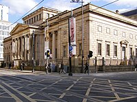
曼彻斯特中央图书馆

曼彻斯特市政厅

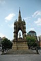
曼彻斯特纪念碑
阿尔伯特广场

米德兰酒店

自由贸易厅


|
|
|
|
|---|


参见
- 曼彻斯特最高建筑物列表
- 中曼徹斯特 (英國國會選區)
- 曼彻斯特
参考来源
^ Manchester City Centre Office Market Report (PDF). GVA Grimley. Spring 2008 [2013-06-22]. (原始内容 (PDF)存档于2008-12-21).
^ Visit Manchester – Manchester city centre map (PDF). visitmanchester.com. [2014-11-23]. [永久失效連結]
^ City of Manchester Ward population 2011. [2016-01-04].
^ Gregory 2007, pp. 1–3.
^ Manchester and Leeds: Could they rival London?. BBC News. 23 June 2014 [2014-11-23].
^ Rate of take-up on Manchester city centre offices doubles as economy reaches pre-recession point. mancunianmatters.co.uk. 2014-11-23.
- Sources.mw-parser-output .refbegin{font-size:90%;margin-bottom:0.5em}.mw-parser-output .refbegin-hanging-indents>ul{list-style-type:none;margin-left:0}.mw-parser-output .refbegin-hanging-indents>ul>li,.mw-parser-output .refbegin-hanging-indents>dl>dd{margin-left:0;padding-left:3.2em;text-indent:-3.2em;list-style:none}.mw-parser-output .refbegin-100{font-size:100%}
Gregory, Richard (ed). Roman Manchester: The University of Manchester's Excavations within the Vicus 2001–5. Oxford: Oxbow Books. 2007. ISBN 978-1-84217-271-1.
Hylton, Stuart. A History of Manchester. Chichester: Phillimore and co. Ltd. 2003. ISBN 1-86077-240-4.
Kellie, Euan. Rebuilding Manchester. Derby: Derby Books. 2010. ISBN 978-1-85983-786-3.
Kidd, Alan. Manchester. Keele: Keele University Press. [1996] 1993. ISBN 1-85331-028-X. 请检查|date=中的日期值 (帮助)
McKechnie, H. M., ed. Manchester in Nineteen Hundred and Fifteen. Manchester: University of Manchester Press. 1915.
Nevell, Mike. Manchester: The Hidden History. The History Press. 2008. ISBN 978-0-7524-4704-9.
Newman, Caron. Medieval Period Resource Assessment. Archaeology North West. 2006, 8: 115–144. ISSN 0962-4201.
Ravetz, Joe. City-Region 2020. Earthscan. 2000. ISBN 978-1-85383-606-0.
Atkins, Philip. Guide Across Manchester. Manchester: Civic Trust for the North West. 1976. ISBN 0-901347-29-9.
Bradshaw, L. D. Origins of Street Names in the City of Manchester. Radcliffe: Neil Richardson. 1985. ISBN 0-907511-87-2.
外部链接
[1] – Visit Manchester website with a link to a city centre map


