U.S. Route 20 in Ohio
U.S. Route 20 | ||||
|---|---|---|---|---|
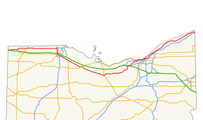 Route of US 20 in red across northern Ohio | ||||
| Route information | ||||
| Maintained by ODOT | ||||
| Length | 260.40 mi[1] (419.07 km) | |||
| Existed | 1926–present | |||
| Major junctions | ||||
| West end | ||||
| East end | ||||
| Location | ||||
| Counties | Williams, Fulton, Lucas, Wood, Sandusky, Huron, Lorain, Cuyahoga, Lake, Ashtabula | |||
| Highway system | ||||
| ||||

U.S. Route 20 (US 20) is a United States Numbered Highway that runs from Newport, Oregon to Boston, Massachusetts. Within the state of Ohio, the route runs from the Indiana border near Edon to the Pennsylvania border at Conneaut. The route passes through rural areas west of Toledo, and passes through Public Square in Cleveland. It is one of 9 other routes to enter downtown Cleveland at Public Square, and it serves some of Cleveland's northeastern suburbs.
Contents
1 History
2 Route description
3 Junction list
4 References
5 Further reading
History
Prior to the establishment of the U.S. highway system in 1926, the general routing of US 20 was occupied by SR 23 from the Indiana state line to Toledo, SR 102 from Toledo to Woodville, and SR 2 from Woodville east to the Ohio-Pennsylvania border.[2] The route has existed closely to its 1926 routing, except for two bypasses: one built around the north side of Fremont between 1957 and 1958,[3][4] and a second built around the south side of Norwalk by 1967.[5] By 1932 US 20 between Pioneer and Maumee had become US 20N and a US 20S designation had been created to the south between those points;[6] by 1935 US 20N had reverted to US 20 and US 20S had become US 20A.[7]
Route description
US 20 enters the state in Northwest Township, Williams County. The route parallels the Ohio Turnpike (Interstate 80/Interstate 90) through rural farmland in the northwest corner of the state. Within the city of Toledo, the route turns north-south along Reynolds Road, which becomes Conant Street as the route enters Maumee. After crosing the Maumee River into Perrysburg, US 20 continues through downtown Perrysburg, then angles southeasterly, becoming concurrent with US 23 until Woodville. US 20 continues southeasterly towards the bypass of Fremont, most of which is concurrent with US 6.
From Fremont eastward, the route becomes a divided highway, except when passing through the communities of Clyde, Bellevue, and Monroeville. The route bypasses Norwalk to the south as an expressway, with much of the old routing of US 20 maintained as part of SR 61. Near Oberlin, US 20 once again becomes an expressway, until the route continues northward on a divided bypass on the east side of Elyria while the freeway continues easterly as SR 10. US 20 turns east again on the east side of Elyria, following Cleveland Street and Center Ridge Road through western suburban Cleveland.
In Lakewood, the route becomes concurrent with US 6 and SR 2, with a portion of the route following the Cleveland Memorial Shoreway. US 20 departs from the Shoreway then crosses the Detroit-Superior Bridge over the Cuyahoga River into downtown Cleveland. From there, the route passes through Public Square easterly, paralleling U.S. Route 322 one block to the south until nearing Case Western Reserve University. It travels northeasterly through the east side of Cleveland as Euclid Avenue, then through the suburbs of Euclid, Wickliffe, Willoughby, Mentor, Ohio, and Painesville, then continues easterly, roughly paralleling the Lake Erie shoreline through Geneva, Ashtabula, and Conneaut and into Pennsylvania.
Junction list
| County | Location | mi | km | Exit | Destinations | Notes |
|---|---|---|---|---|---|---|
| Williams | Northwest Township | 0.000 | 0.000 | Indiana state line | ||
| 2.066 | 3.325 | Western end of SR 49 overlap | ||||
| 3.072 | 4.944 | Eastern end of SR 49 overlap | ||||
| Bridgewater Township | 9.134 | 14.700 | Western end of SR 576 overlap | |||
| 10.139 | 16.317 | Eastern end of SR 576 overlap | ||||
Bridgewater–Madison township line | 12.109 | 19.488 | Western end of US 20A | |||
| Madison Township | 14.333 | 23.067 | ||||
| Mill Creek Township | 21.989 | 35.388 | Western end of US 127 overlap | |||
| Fulton | Gorham Township | 24.704– 24.763 | 39.757– 39.852 | Eastern end of US 127 overlap | ||
| Fayette | 26.387 | 42.466 | Northern end of SR 66 | |||
| Chesterfield Township | 33.076 | 53.231 | Western end of SR 108 overlap | |||
| 36.078 | 58.062 | Eastern end of SR 108 overlap | ||||
| Royalton Township | 42.108 | 67.766 | ||||
| Assumption | 48.526 | 78.095 | Western end of SR 120 overlap | |||
| Lucas | Richfield Township | 52.343 | 84.238 | |||
| Sylvania | 59.773 | 96.195 | Exit 13 on I-475; Single-point urban interchange | |||
| 60.883 | 97.982 | Eastern end of SR 120 overlap | ||||
| Toledo | 62.633 | 100.798 | Western end of SR 246 | |||
| 65.173 | 104.886 | |||||
| Maumee | 16.640– 16.660 | 26.779– 26.812 | Double trumpet interchange; exit 59 on Ohio Turnpike | |||
| 68.713 | 110.583 | Eastern end of US 20A | ||||
| 68.853 | 110.808 | Western end of SR 25 overlap | ||||
| Wood | Perrysburg | 69.913 | 112.514 | Eastern end of SR 25 overlap; western end of SR 65 overlap | ||
| 70.591 | 113.605 | Eastern end of SR 65 overlap | ||||
| 70.847 | 114.017 | Northern end of SR 199; western end of SR 795 | ||||
| 71.092 | 114.411 | Eastern end of SR 795 overlap | ||||
| 72.240– 72.408 | 116.259– 116.529 | Western end of US 23 overlap; exit 193 on I-75 | ||||
| Troy Township | 78.324 | 126.050 | Western end of SR 163 | |||
| 80.560– 80.751 | 129.649– 129.956 | 81A | To Ohio Turnpike (I-80/I-90); exits 81A and 81B are connected eastbound; SR 420 exits 1A-B | |||
| 81.167 | 130.626 | 81B | Pemberville Road | |||
Wood–Sandusky county line | Troy–Woodville township line | 83.469 | 134.330 | Eastern end of US 23 overlap | ||
| Sandusky | Woodville | 86.109 | 138.579 | Western end of SR 105 overlap | ||
| 86.649 | 139.448 | Eastern end of SR 105 overlap | ||||
| Woodville Township | 89.159 | 143.488 | Northern end of SR 300 | |||
Woodville–Washington township line | 90.299 | 145.322 | Southern end of SR 51 | |||
| Hessville | 93.699 | 150.794 | Eastern end of SR 600 | |||
| Washington Township | 94.899 | 152.725 | ||||
| Sandusky Township | 98.759 | 158.937 | 98 | Western end of US 6 and SR 53 concurrencies; western end of expressway; no access from westbound US 20 to eastbound State Street; formerly exit 92 | ||
| Fremont | 99.979 | 160.901 | 100 | Western end of SR 19 overlap; formerly exit 94 | ||
| 100.739 | 162.124 | 101 | Eastern end of SR 53 overlap; formerly exit 95 | |||
| 102.149 | 164.393 | 102 | Eastern end of US 6 overlap | |||
| Sandusky Township | 103.099 | 165.922 | 103 | |||
| Green Creek Township | 104.769 | 168.609 | 105 | State Street — Fremont | Westbound exit and eastbound entrance; eastern end of expressway | |
| 105.389 | 169.607 | Eastern end of SR 19 overlap | ||||
| Clyde | 109.679 | 176.511 | Southern end of SR 510 | |||
| 109.869 | 176.817 | |||||
Sandusky–Huron county line | Bellevue | 117.109 | 188.469 | Western end of SR 18 overlap | ||
| 117.199 | 188.614 | |||||
| Huron | 118.079 | 190.030 | Western end of SR 113 | |||
| 119.609 | 192.492 | |||||
| Monroeville | 124.459 | 200.297 | ||||
| Eastern end of SR 547 | ||||||
| Ridgefield Township | 128.789 | 207.266 | — | Eastbound exit and westbound entrance | ||
| Norwalk | 130.599 | 210.179 | — | |||
| 132.429 | 213.124 | — | Eastern end of SR 18 overlap | |||
| — | Cleveland Road | East end of expressway | ||||
Norwalk–Townsend township line | 134.929 | 217.147 | ||||
| Wakeman | 141.869 | 228.316 | Western end of SR 303 | |||
| 142.719– 142.849 | 229.684– 229.893 | SR 60 is concurrent for one block | ||||
| Lorain | Camden Township | 147.849 | 237.940 | |||
| Oberlin | 152.389 | 245.246 | ||||
| New Russia Township | 155.729 | 250.622 | — | Eastern end of SR 511 | ||
| Carlisle Township | 158.809 | 255.578 | — | Western end of SR 301 overlap | ||
| 161.109 | 259.280 | — | Grafton Road | |||
| Eaton Township | 161.719– 161.999 | 260.262– 260.712 | — | Eastern end of expressway, which continues eastbound as SR 10; US 20 and SR 301 depart eastbound via exit ramp; western end of SR 57 overlap | ||
| Elyria | 165.199 | 265.862 | Eastern end of SR 301 and SR 57 concurrencies; western end of SR 113 overlap | |||
| North Ridgeville | 168.339 | 270.915 | ||||
| Cuyahoga | Westlake | 176.089 | 283.388 | |||
| Rocky River | 180.739 | 290.871 | Eastern end of SR 254; northern end of SR 113; western end of ALT US 6 overlap | |||
| Lakewood | 180.899 | 291.129 | Eastern end of Alt. US 6 overlap | |||
| 181.449 | 292.014 | Western end of SR 237 overlap | ||||
| 181.789 | 292.561 | Western end of US 6 and SR 2 concurrencies; northern end of SR 237 | ||||
| Cleveland | Western end of Cleveland Memorial Shoreway | |||||
| — | Lake Avenue, West Boulevard | Westbound exit and eastbound entrance | ||||
| — | Edgewater Park, Whiskey Island | |||||
| — | West 45th Street, West 49th Street | 45th Street signed eastbound only; 49th Street signed westbound only; all trucks must exit at 49th Street westbound | ||||
| 188.069 | 302.668 | US 6 and US 20 exit onto 25th Street; SR 2 continues eastbound on the Shoreway; eastern end of SR 2 overlap | ||||
| 188.109 | 302.732 | Western end of US 42 and SR 3 concurrencies | ||||
Detroit-Superior Bridge over the Cuyahoga River | ||||||
| 188.789 | 303.826 | Eastern terminus of US 6 / US 42 concurrency; eastern terminus of US 42; western terminus of US 322 / US 422 / SR 14 / SR 87; northern terminus of SR 3 / SR 8 / SR 43 | ||||
| Western end of US 322 overlap. | ||||||
| Eastern end of US 322 overlap. | ||||||
| East Cleveland | Western end of US 6 overlap | |||||
| Euclid | Eastern end of US 6 overlap; western end of SR 84 | |||||
Cuyahoga–Lake county line | Euclid–Wickliffe city line | Exit 186 on I-90 | ||||
| Lake | Willoughby | |||||
| Northern end of SR 174 | ||||||
| Eastern end of SR 640 | ||||||
| Mentor | ||||||
| Painesville | Southbound exit and northbound entrance from SR 44; ramps connect to US 20 via Fern Drive | |||||
| Southern end of SR 283 | ||||||
| Northern end of SR 86 | ||||||
| Painesville Township | Eastern end of SR 535 | |||||
| Westbound exit and eastbound entrance; eastbound exit and westbound entrance are via SR 535 West; eastern end of SR 2 | ||||||
| Madison Township | Northern end of SR 528 | |||||
| Ashtabula | Geneva | |||||
| Saybrook Township | ||||||
| Ashtabula Township | Exit 97 on SR 11 | |||||
| North Kingsville | ||||||
| Conneaut | Western end of SR 7 overlap | |||||
| Eastern end of SR 7 overlap | ||||||
| 260.40 | 419.07 | Continuation into Pennsylvania | ||||
1.000 mi = 1.609 km; 1.000 km = 0.621 mi
| ||||||
| Previous state: Indiana | Ohio | Next state: Pennsylvania |
References
^ "DESTAPE". Ohio Department of Transportation. July 3, 2014. Retrieved September 29, 2014: Williams, Fulton, Lucas, Wood, Sandusky, Huron, Lorain, Cuyahoga, Lake, Ashtabula..mw-parser-output cite.citation{font-style:inherit}.mw-parser-output .citation q{quotes:"""""""'""'"}.mw-parser-output .citation .cs1-lock-free a{background:url("//upload.wikimedia.org/wikipedia/commons/thumb/6/65/Lock-green.svg/9px-Lock-green.svg.png")no-repeat;background-position:right .1em center}.mw-parser-output .citation .cs1-lock-limited a,.mw-parser-output .citation .cs1-lock-registration a{background:url("//upload.wikimedia.org/wikipedia/commons/thumb/d/d6/Lock-gray-alt-2.svg/9px-Lock-gray-alt-2.svg.png")no-repeat;background-position:right .1em center}.mw-parser-output .citation .cs1-lock-subscription a{background:url("//upload.wikimedia.org/wikipedia/commons/thumb/a/aa/Lock-red-alt-2.svg/9px-Lock-red-alt-2.svg.png")no-repeat;background-position:right .1em center}.mw-parser-output .cs1-subscription,.mw-parser-output .cs1-registration{color:#555}.mw-parser-output .cs1-subscription span,.mw-parser-output .cs1-registration span{border-bottom:1px dotted;cursor:help}.mw-parser-output .cs1-ws-icon a{background:url("//upload.wikimedia.org/wikipedia/commons/thumb/4/4c/Wikisource-logo.svg/12px-Wikisource-logo.svg.png")no-repeat;background-position:right .1em center}.mw-parser-output code.cs1-code{color:inherit;background:inherit;border:inherit;padding:inherit}.mw-parser-output .cs1-hidden-error{display:none;font-size:100%}.mw-parser-output .cs1-visible-error{font-size:100%}.mw-parser-output .cs1-maint{display:none;color:#33aa33;margin-left:0.3em}.mw-parser-output .cs1-subscription,.mw-parser-output .cs1-registration,.mw-parser-output .cs1-format{font-size:95%}.mw-parser-output .cs1-kern-left,.mw-parser-output .cs1-kern-wl-left{padding-left:0.2em}.mw-parser-output .cs1-kern-right,.mw-parser-output .cs1-kern-wl-right{padding-right:0.2em}
^ 1925 Official Highway Map (Map). Ohio Department of Highways. 1925.
^ 1957 Official Highway Map (Map). Ohio Department of Highways. 1957. § G4.
^ 1958 Official Highway Map (Map). Ohio Department of Highways. 1958. § G4.
^ 1967 Official Highway Map (Map). Ohio Department of Highways. 1967. § I5.
^ 1932 Official Highway Map (Map). Ohio Department of Highways. 1932.
^ 1935 Official Highway Map (Map). Ohio Department of Highways. 1935.
Further reading
KML file (edit • help) |
Harter, Kevin (1995-06-18). "The Road Less Traveled". The Plain Dealer Sunday magazine. pp. 8–13.


