Halsa
Halsa kommune | |
|---|---|
Municipality | |
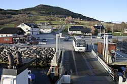 Ferry quay in Halsanaustan | |
 Coat of arms  .mw-parser-output .nobold{font-weight:normal} Møre og Romsdal within Norway | |
 Halsa within Møre og Romsdal | |
| Coordinates: 63°06′50″N 08°28′13″E / 63.11389°N 8.47028°E / 63.11389; 8.47028Coordinates: 63°06′50″N 08°28′13″E / 63.11389°N 8.47028°E / 63.11389; 8.47028 | |
| Country | Norway |
| County | Møre og Romsdal |
| District | Nordmøre |
| Administrative centre | Liabøen |
| Government | |
| • Mayor (2007) | Ola Rognskog (Sp) |
| Area | |
| • Total | 300.53 km2 (116.04 sq mi) |
| • Land | 292.29 km2 (112.85 sq mi) |
| • Water | 8.24 km2 (3.18 sq mi) |
| Area rank | #279 in Norway |
| Population (2017) | |
| • Total | 1,599 |
| • Rank | #347 in Norway |
| • Density | 5.5/km2 (14/sq mi) |
| • Change (10 years) | -4.3% |
| Demonym(s) | Halsabygg[1] |
| Time zone | UTC+01:00 (CET) |
| • Summer (DST) | UTC+02:00 (CEST) |
| ISO 3166 code | NO-1571 |
| Official language form | Neutral |
| Website | www.halsa.kommune.no |
Data from Statistics Norway | |
Halsa is a municipality in Møre og Romsdal county, Norway. It is part of the Nordmøre region. The administrative centre of Halsa is the village of Liabøen. Other villages in the municipality include Todalen, Halsanaustan, Valsøyfjord, Engan, Hjellnes, and Valsøybotnen.
The 301-square-kilometre (116 sq mi) municipality is the 279th largest by area out of the 422 municipalities in Norway. Halsa is the 347th most populous municipality in Norway with a population of 1,599. The municipality's population density is 5.5 inhabitants per square kilometre (14/sq mi) and its population has decreased by 4.3% over the last decade.[2]
Contents
1 General information
1.1 Name
1.2 Coat-of-arms
1.3 Churches
2 Geography
3 Government
3.1 Municipal council
4 Attractions
5 References
6 External links
General information

View of the Skålvik Fjord

View of the Valsøyfjorden
Halsa was established as a municipality on 1 January 1838 (see formannskapsdistrikt). On 1 January 1868, an unpopulated area of Halsa was transferred to Straumsnes. On 1 January 1879, a part of Halsa (population: 279) was transferred to Stangvik. The next year, the Torjulvågen area (population: 240) across the Halsafjorden was transferred to Tingvoll Municipality. On 1 July 1915, part of southern Halsa (population: 114) was transferred to Åsskard Municipality. On 1 January 1965, all of the municipality Valsøyfjord that was located on the mainland (population: 1,104) was merged into Halsa. On 1 January 1976, the district of Aure Municipality south of the Vinjefjorden (population: 158) was transferred to Halsa Municipality.[3]
On 1 January 2020, Halsa will merge with the neighboring municipality of Hemne and the Ytre Snillfjord area in the municipality of Snillfjord. The new municipality will be located in Trøndelag county, which means that as part of the merger Halsa will also leave Møre og Romsdal and move to Trøndelag.[4]
Name
The municipality (originally the parish) is named after the old Halsa farm (Old Norse: Hǫlsyinjar), since the first church (Halsa Church) was built there. The first element is hals which means "neck" and the last element is the plural form of vin which means "meadow" or "pasture". Here, the word hals is referring to an isthmus (neck of land) between two fjords: Halsafjorden and the Skålvik Fjord. Before 1918, the name was written "Halse".[5]
Coat-of-arms
The coat-of-arms is from modern times. They were granted on 19 August 1988. The gray and blue motif represents the three fjords and headlands of the municipality.[6]
Churches
The Church of Norway has two parishes (sokn) within the municipality of Halsa. It is part of the Indre Nordmøre deanery in the Diocese of Møre.
| Parish (Sokn) | Church Name | Location of the Church | Year Built |
|---|---|---|---|
| Halsa | Halsa Church | Halsanaustan | 1734 |
| Valsøyfjord | Valsøyfjord Church | Valsøyfjord | 1864 |
Geography
Halsa has numerous fjords in and around the municipality including the Halsafjorden, Vinjefjorden, Arasvikfjorden, the Skålvik Fjord, and Valsøyfjorden. The Valsøy Bridge crosses the Valsøyfjorden. There are ferry connections to Tingvoll Municipality to the west and to Aure Municipality to the north.
Government
All municipalities in Norway, including Halsa, are responsible for primary education (through 10th grade), outpatient health services, senior citizen services, unemployment and other social services, zoning, economic development, and municipal roads. The municipality is governed by a municipal council of elected representatives, which in turn elect a mayor.
Municipal council
The municipal council (Kommunestyre) of Halsa is made up of 15 representatives that are elected to four year terms. Currently, the party breakdown is as follows:[7]
| Party Name | Name in Norwegian | Number of representatives | |
|---|---|---|---|
| Labour Party | Arbeiderpartiet | 3 | |
| Conservative Party | Høyre | 2 | |
| Centre Party | Senterpartiet | 10 | |
| Total number of members: | 15 | ||
Attractions
Halsa is the location where the famous killer whale, Keiko, went when he was set free. Keiko died in December 2003 and was buried there. The people of Halsa have built a memorial cairn over Keiko's body, where people from all over the world are free to visit him. In the first year after his burial, around 5,000 people visited the grave but then fewer and fewer came and in 2007 only around 500 visitors paid him homage. In June 2008, hardly anyone had come to see the grave, so the municipality decided it would not continue keeping the grave in order.[citation needed]
References
^ "Navn på steder og personer: Innbyggjarnamn" (in Norwegian). Språkrådet. Retrieved 2015-12-01..mw-parser-output cite.citation{font-style:inherit}.mw-parser-output .citation q{quotes:"""""""'""'"}.mw-parser-output .citation .cs1-lock-free a{background:url("//upload.wikimedia.org/wikipedia/commons/thumb/6/65/Lock-green.svg/9px-Lock-green.svg.png")no-repeat;background-position:right .1em center}.mw-parser-output .citation .cs1-lock-limited a,.mw-parser-output .citation .cs1-lock-registration a{background:url("//upload.wikimedia.org/wikipedia/commons/thumb/d/d6/Lock-gray-alt-2.svg/9px-Lock-gray-alt-2.svg.png")no-repeat;background-position:right .1em center}.mw-parser-output .citation .cs1-lock-subscription a{background:url("//upload.wikimedia.org/wikipedia/commons/thumb/a/aa/Lock-red-alt-2.svg/9px-Lock-red-alt-2.svg.png")no-repeat;background-position:right .1em center}.mw-parser-output .cs1-subscription,.mw-parser-output .cs1-registration{color:#555}.mw-parser-output .cs1-subscription span,.mw-parser-output .cs1-registration span{border-bottom:1px dotted;cursor:help}.mw-parser-output .cs1-ws-icon a{background:url("//upload.wikimedia.org/wikipedia/commons/thumb/4/4c/Wikisource-logo.svg/12px-Wikisource-logo.svg.png")no-repeat;background-position:right .1em center}.mw-parser-output code.cs1-code{color:inherit;background:inherit;border:inherit;padding:inherit}.mw-parser-output .cs1-hidden-error{display:none;font-size:100%}.mw-parser-output .cs1-visible-error{font-size:100%}.mw-parser-output .cs1-maint{display:none;color:#33aa33;margin-left:0.3em}.mw-parser-output .cs1-subscription,.mw-parser-output .cs1-registration,.mw-parser-output .cs1-format{font-size:95%}.mw-parser-output .cs1-kern-left,.mw-parser-output .cs1-kern-wl-left{padding-left:0.2em}.mw-parser-output .cs1-kern-right,.mw-parser-output .cs1-kern-wl-right{padding-right:0.2em}
^ Statistisk sentralbyrå (2017). "Table: 06913: Population 1 January and population changes during the calendar year (M)" (in Norwegian). Retrieved 2017-10-14.
^ Jukvam, Dag (1999). "Historisk oversikt over endringer i kommune- og fylkesinndelingen" (PDF) (in Norwegian). Statistisk sentralbyrå.
^ "Ny kommune - Halsa, Snillfjord og Hemne" (in Norwegian). Retrieved 2017-10-05.
^ Rygh, Oluf (1908). Norske gaardnavne: Romsdals amt (in Norwegian) (13 ed.). Kristiania, Norge: W. C. Fabritius & sønners bogtrikkeri. p. 448.
^ "Kommunevåpen" (in Norwegian). Halsa Kommune. Archived from the original on 2012-03-07. Retrieved 2008-10-18.
^ "Table: 04813: Members of the local councils, by party/electoral list at the Municipal Council election (M)" (in Norwegian). Statistics Norway. 2015.
External links
 Media related to Halsa at Wikimedia Commons
 Møre og Romsdal travel guide from Wikivoyage
Municipal fact sheet from Statistics Norway (in Norwegian)
Møre og Romsdal county, Norway | |||||||||||||||||||||||||||||||||||||
|---|---|---|---|---|---|---|---|---|---|---|---|---|---|---|---|---|---|---|---|---|---|---|---|---|---|---|---|---|---|---|---|---|---|---|---|---|---|
 |
|  | |||||||||||||||||||||||||||||||||||
||


