Maku County
Maku County شهرستان ماکو | |
|---|---|
| County | |
 Counties of West Azerbaijan Province | |
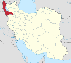 Location of West Azerbaijan Province in Iran | |
| Country | |
| Province | West Azerbaijan |
| Capital | Maku |
Bakhsh (Districts) | Central District, Bazargan District |
| Population (2006) | |
| • Total | 84,516 |
| Time zone | UTC+3:30 (IRST) |
| • Summer (DST) | UTC+4:30 (IRDT) |
Maku County (Persian: شهرستان ماکو) is a county in West Azerbaijan Province in Iran. The capital of the county is Maku. At the 2006 census, the county's population (including those portions that were later split off to form Poldasht County and Showt County) was 174,578, in 39,765 families; excluding those portions, the population was 84,516 in 19,238 families.[1] The county is subdivided into two districts: the Central District and Bazargan District.[2] The county has two cities: Maku and Bazargan.
References
^ "Census of the Islamic Republic of Iran, 1385 (2006)". Islamic Republic of Iran. Archived from the original (Excel) on 2011-11-11..mw-parser-output cite.citation{font-style:inherit}.mw-parser-output q{quotes:"""""""'""'"}.mw-parser-output code.cs1-code{color:inherit;background:inherit;border:inherit;padding:inherit}.mw-parser-output .cs1-lock-free a{background:url("//upload.wikimedia.org/wikipedia/commons/thumb/6/65/Lock-green.svg/9px-Lock-green.svg.png")no-repeat;background-position:right .1em center}.mw-parser-output .cs1-lock-limited a,.mw-parser-output .cs1-lock-registration a{background:url("//upload.wikimedia.org/wikipedia/commons/thumb/d/d6/Lock-gray-alt-2.svg/9px-Lock-gray-alt-2.svg.png")no-repeat;background-position:right .1em center}.mw-parser-output .cs1-lock-subscription a{background:url("//upload.wikimedia.org/wikipedia/commons/thumb/a/aa/Lock-red-alt-2.svg/9px-Lock-red-alt-2.svg.png")no-repeat;background-position:right .1em center}.mw-parser-output .cs1-subscription,.mw-parser-output .cs1-registration{color:#555}.mw-parser-output .cs1-subscription span,.mw-parser-output .cs1-registration span{border-bottom:1px dotted;cursor:help}.mw-parser-output .cs1-hidden-error{display:none;font-size:100%}.mw-parser-output .cs1-visible-error{font-size:100%}.mw-parser-output .cs1-subscription,.mw-parser-output .cs1-registration,.mw-parser-output .cs1-format{font-size:95%}.mw-parser-output .cs1-kern-left,.mw-parser-output .cs1-kern-wl-left{padding-left:0.2em}.mw-parser-output .cs1-kern-right,.mw-parser-output .cs1-kern-wl-right{padding-right:0.2em}
^ Iranian National Committee for Standardization of Geographical Names website (in Persian)
- اطلس گیتاشناسی استانهای ایران [Atlas Gitashenasi Ostanhai Iran] (Gitashenasi Province Atlas of Iran)
List of cities, towns and villages in West Azerbaijan Province | ||
| Capital |
|  |
Counties and cities |
| |
| Tourism |
| |
| Places | List of cities, towns and villages in West Azerbaijan Province | |
| Capital |
| ||||||||||||||||||
|---|---|---|---|---|---|---|---|---|---|---|---|---|---|---|---|---|---|---|---|
| Districts |
| ||||||||||||||||||
Coordinates: 39°17′45″N 44°30′48″E / 39.295822°N 44.513234°E / 39.295822; 44.513234
This West Azerbaijan province location article is a stub. You can help Wikipedia by expanding it. |


