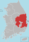
North Gyeongsang Province
Coordinates: 36°15′N 128°45′E / 36.250°N 128.750°E / 36.250; 128.750
North Gyeongsang Province .mw-parser-output .nobold{font-weight:normal} 경상북도 | ||
|---|---|---|
Province | ||
| Korean transcription(s) | ||
| • Hangul | 경상북도 | |
| • Hanja | 慶尙北道 | |
| • McCune‑Reischauer | Kyŏngsang-bukto | |
| • Revised Romanization | Gyeongsangbuk-do | |
| ||
 | ||
| Country | South Korea | |
| Region | Yeongnam | |
| Capital | Andong | |
| Subdivisions | 10 cities; 13 counties | |
| Government | ||
| • Governor | Lee Cheol-woo (Liberty Korea) | |
| Area | ||
| • Total | 19,030 km2 (7,350 sq mi) | |
| Area rank | 1st | |
| Population (October, 2014)[1] | ||
| • Total | 2,700,328 | |
| • Rank | 3rd | |
| • Density | 141.7/km2 (367/sq mi) | |
| Metropolitan Symbols | ||
| • Flower | Crape-myrtle | |
| • Tree | Zelcova | |
| • Bird | Common heron | |
| Dialect | Gyeongsang | |
| Website | gb.go.kr | |

North Gyeongsang Province (Korean: 경상북도; RR: Gyeongsangbuk-do; Korean pronunciation: [kjʌŋ.saŋ.buk̚.t͈o]), also known as Gyeongbuk (Korean pronunciation: [kjʌŋ.buk̚]), is a province in eastern South Korea. The province was formed in 1896 from the northern half of the former Gyeongsang province, remained a province of Korea until the country's division in 1945, then became part of South Korea.
Daegu was the capital of North Gyeongsang Province between 1896 and 1981, but has not been a part of the province since 1981. In 2016, the provincial capital moved from Daegu to Andong.[2]
The area of the province is 19,030 square kilometres (7,350 sq mi), 19.1% of the total area of South Korea.[3]
Contents
1 Geography and climate
2 Culture
3 Religion
4 Administrative divisions
5 See also
6 References
7 External links
Geography and climate
The province is part of the Yeongnam region, on the south by Gyeongsangnam-do, on the west by Jeollabuk-do and Chungcheongbuk-do Provinces, and on the north by Gangwon-do Province. During the summer, Gyeongsangbuk-do is perhaps the hottest province in South Korea. This is helped by the fact that the province is largely surrounded by mountains: the Taebaek Mountains in the east and the Sobaek Mountains in the west.
Culture
Gyeongsangbuk-do is the homeland of the former kingdom of Silla and has retained much of its cultural tradition. A number of artists, political leaders and scholars have come from the province.

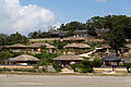
View of Hahoe Folkvillage in Andong
View of Yangdong Folk Village in Gyeongju

View of Muryangsojieon lantern statue and Buseoksa Temple in Yeongju
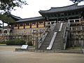
Bulguk Temple in Gyeongju


Religion
Religion in North Gyeongsang (2005)[4]
Not religious (47.5%)
Buddhism (33.9%)
Protestantism (11.5%)
Catholicism (7.1%)
According to the census of 2005, of the people of North Gyeongsang 33.9% follow Buddhism and 18.6% follow Christianity (11.5% Protestantism and 7.1% Catholicism).[4] 47.5% of the population is mostly not religious or follow Muism and other indigenous religions.
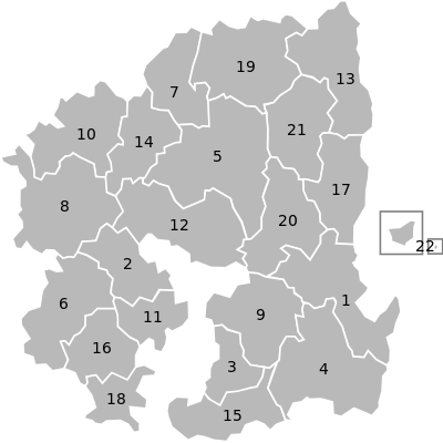
Administrative divisions
Gyeongsangbuk-do is divided into 10 cities (si) and 13 counties (gun). The names below are given in English, hangul, and hanja.

Night view of Pohang
| Map | # | Name | Hangul | Hanja | Population (2013)[5] | Subdivisions |
|---|---|---|---|---|---|---|
 | ||||||
— Specific City — | ||||||
| 1 | Pohang | 포항시 | 浦項市 | 519,060 | 2 ilban-gu — 4 eup, 10 myeon, 15 haengjeong-dong | |
— City — | ||||||
| 2 | Gumi | 구미시 | 龜尾市 | 417,708 | 2 eup, 6 myeon, 19 haengjeong-dong | |
| 3 | Gyeongsan | 경산시 | 慶山市 | 247,613 | 2 eup, 6 myeon, 7 haengjeong-dong | |
| 4 | Gyeongju | 경주시 | 慶州市 | 263,704 | 4 eup, 8 myeon, 11 haengjeong-dong | |
| 5 | Andong | 안동시 | 安東市 | 167,826 | 1 eup, 13 myeon, 10 haengjeong-dong | |
| 6 | Gimcheon | 김천시 | 金泉市 | 135,191 | 1 eup, 14 myeon, 7 haengjeong-dong | |
| 7 | Yeongju | 영주시 | 榮州市 | 112,482 | 1 eup, 9 myeon, 9 haengjeong-dong | |
| 8 | Sangju | 상주시 | 尙州市 | 103,950 | 1 eup, 17 myeon, 6 haengjeong-dong | |
| 9 | Yeongcheon | 영천시 | 永川市 | 101,295 | 1 eup, 10 myeon, 5 haengjeong-dong | |
| 10 | Mungyeong | 문경시 | 聞慶市 | 75,749 | 2 eup, 7 myeon, 5 haengjeong-dong | |
— County — | ||||||
| 11 | Chilgok County | 칠곡군 | 漆谷郡 | 120,135 | 3 eup, 5 myeon | |
| 12 | Uiseong County | 의성군 | 義城郡 | 56,777 | 1 eup, 17 myeon | |
| 13 | Uljin County | 울진군 | 蔚珍郡 | 51,723 | 2 eup, 8 myeon | |
| 14 | Yecheon County | 예천군 | 醴泉郡 | 45,948 | 1 eup, 11 myeon | |
| 15 | Cheongdo County | 청도군 | 淸道郡 | 43,787 | 2 eup, 7 myeon | |
| 16 | Seongju County | 성주군 | 星州郡 | 44,824 | 1 eup, 9 myeon | |
| 17 | Yeongdeok County | 영덕군 | 盈德郡 | 40,213 | 1 eup, 8 myeon | |
| 18 | Goryeong County | 고령군 | 高靈郡 | 35,281 | 1 eup, 7 myeon | |
| 19 | Bonghwa County | 봉화군 | 奉化郡 | 33,936 | 1 eup, 9 myeon | |
| 20 | Cheongsong County | 청송군 | 靑松郡 | 26,432 | 1 eup, 7 myeon | |
| 21 | Gunwi County | 군위군 | 軍威郡 | 24,104 | 1 eup, 7 myeon | |
| 22 | Yeongyang County | 영양군 | 英陽郡 | 18,259 | 1 eup, 5 myeon | |
| 23 | Ulleung County | 울릉군 | 鬱陵郡 | 10,557 | 1 eup, 2 myeon | |
See also
- List of Korea-related topics
- Liancourt Rocks
References
^ "Archived copy". Archived from the original on 29 November 2014. Retrieved 1 October 2015.CS1 maint: Archived copy as title (link) .mw-parser-output cite.citation{font-style:inherit}.mw-parser-output q{quotes:"""""""'""'"}.mw-parser-output code.cs1-code{color:inherit;background:inherit;border:inherit;padding:inherit}.mw-parser-output .cs1-lock-free a{background:url("//upload.wikimedia.org/wikipedia/commons/thumb/6/65/Lock-green.svg/9px-Lock-green.svg.png")no-repeat;background-position:right .1em center}.mw-parser-output .cs1-lock-limited a,.mw-parser-output .cs1-lock-registration a{background:url("//upload.wikimedia.org/wikipedia/commons/thumb/d/d6/Lock-gray-alt-2.svg/9px-Lock-gray-alt-2.svg.png")no-repeat;background-position:right .1em center}.mw-parser-output .cs1-lock-subscription a{background:url("//upload.wikimedia.org/wikipedia/commons/thumb/a/aa/Lock-red-alt-2.svg/9px-Lock-red-alt-2.svg.png")no-repeat;background-position:right .1em center}.mw-parser-output .cs1-subscription,.mw-parser-output .cs1-registration{color:#555}.mw-parser-output .cs1-subscription span,.mw-parser-output .cs1-registration span{border-bottom:1px dotted;cursor:help}.mw-parser-output .cs1-hidden-error{display:none;font-size:100%}.mw-parser-output .cs1-visible-error{font-size:100%}.mw-parser-output .cs1-subscription,.mw-parser-output .cs1-registration,.mw-parser-output .cs1-format{font-size:95%}.mw-parser-output .cs1-kern-left,.mw-parser-output .cs1-kern-wl-left{padding-left:0.2em}.mw-parser-output .cs1-kern-right,.mw-parser-output .cs1-kern-wl-right{padding-right:0.2em}
^ "도로망 구축 10조 원, 경북도청 신청사 지역의 위용(사진)" (in Korean). Huffington Post. 2016-02-15. Retrieved 2016-02-23.
^ 경북현황 (in Korean). North Gyeongsang Province. Retrieved 18 March 2013.
^ ab 2005 Census - Religion Results Archived 4 September 2015 at the Wayback Machine.
^ 2013년 1분기 주민등록인구현황 (in Korean). North Gyeongsang Province. March 2013. Retrieved 10 June 2013.
External links
- Gyeongsangbuk-do provincial government in English
(in French) Alsace/Gyeongsangbuk-do
 North Gyeongsang Province travel guide from Wikivoyage
Places adjacent to North Gyeongsang Province | ||||||||||
|---|---|---|---|---|---|---|---|---|---|---|
| ||||||||||
North Gyeongsang Province | ||||
|---|---|---|---|---|
Andong (capital) | ||||
 | Specific city |
| ||
| Cities |
| |||
| Counties |
| |||
| Regions |
|
|---|---|
| Provinces |
|
| Special autonomous province |
|
| Special city |
|
| Special autonomous city |
|
| Metropolitan cities |
|
| The Committee for the Five Northern Korean Provinces |
|
Authority control |
|
|---|


