The Ridgeway
| The Ridgeway | |
|---|---|
 The Ridgeway in Grim's Ditch near Mongewell | |
| Length | 87 miles (139km) |
| Location | southern England, United Kingdom |
| Designation | UK National Trail |
| Trailheads | Overton Hill, near Avebury, Wiltshire and Ivinghoe Beacon, Buckinghamshire |
| Use | Hiking |
| Elevation | |
| Elevation change | 3,881 feet (1,183 m)[1] |
| Hiking details | |
| Season | All year |
| Trail map | |
 Map of the Ridgeway National Trail in the south of England Map of the Ridgeway National Trail in the south of England | |
Ivinghoe Beacon (the eastern trailhead) seen looking north from The Ridgeway

The ancient tree-lined path winds over the downs countryside

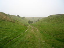
The Ridgeway passing through open downland
Path down from the Ridgeway to Bishopstone, Wiltshire
The Ridgeway is a ridgeway or ancient trackway described as Britain's oldest road. The section clearly identified as an ancient trackway extends from Wiltshire along the chalk ridge of the Berkshire Downs to the River Thames at the Goring Gap, part of the Icknield Way which ran, not always on the ridge, from Salisbury Plain to East Anglia.[2] The route was adapted and extended as a National Trail, created in 1972. The Ridgeway National Trail follows the ancient Ridgeway from Overton Hill, near Avebury, to Streatley, then follows footpaths and parts of the ancient Icknield Way through the Chiltern Hills to Ivinghoe Beacon in Buckinghamshire. The National Trail is 87 miles (140 km) long.
Contents
1 History
2 National Trail
3 Places along the Ridgeway
4 References
5 Maps
6 External links
History
For at least 5,000 years travellers have used the Ridgeway.[3] The Ridgeway provided a reliable trading route to the Dorset coast and to the Wash in Norfolk. The high dry ground made travel easy and provided a measure of protection by giving traders a commanding view, warning against potential attacks.

The Ridgeway (Uffington Castle ringfort in distance on left)
The Bronze Age saw the development of Uffington White Horse and the stone circle at Avebury. During the Iron Age, inhabitants took advantage of the high ground by building hillforts along the Ridgeway to help defend the trading route. Following the collapse of Roman authority in Western Europe, invading Saxon and Viking armies used it. In medieval times and later, the Ridgeway found use by drovers, moving their livestock from the West Country and Wales to markets in the Home Counties and London. Before the Enclosure Acts of 1750, the Ridgeway existed as an informal series of tracks across the chalk downs, chosen by travellers based on path conditions. Once enclosures started, the current path developed through the building of earth banks and the planting of hedges.
National Trail
The idea for a long-distance path along the line of the Wessex Downs and Chilterns goes back to the Hobhouse Committee of 1947. The present route was designated by the Government in 1972, and opened as a National Trail in 1973.[4]
One of fifteen long-distance National Trails in England and Wales, the Ridgeway travels for 87 miles (140 km) northeast from Overton Hill within the Avebury World Heritage Site to Ivinghoe Beacon near Tring. At Marlborough it meets the Wessex Ridgeway, a footpath opened in 1994 which follows the southwest section of the ancient track into Dorset, as far as Lyme Regis. At Ivinghoe Beacon the Ridgeway meets the Icknield Way Path which continues northeast towards Suffolk. The Ridgeway meets the more recent (1997) Thames Path National Trail at the Goring Gap, where the trails use opposite banks of the River Thames between Goring-on-Thames and Mongewell; the Thames Path follows the western bank and the Ridgeway the eastern.
The total height climbed along the path is 3,881 feet (1,183 m).[1] The official guide to the trail divides The Ridgeway into six sections.[5] It is possible to join or leave the trail at other locations with public transport links including Avebury, Swindon, Wantage, Wallingford, Princes Risborough and Tring.
| Section | Start point | Finish point | Distance | Ascent | Descent |
|---|---|---|---|---|---|
| 1 | Overton Hill | Ogbourne St George | 9.0 miles (14.5 km) | 627 feet (191 m) | 866 feet (264 m) |
| 2 | Ogbourne St George | Sparsholt Firs | 16 miles (25 km) | 1,381 feet (421 m) | 1,155 feet (352 m) |
| 3 | Sparsholt Firs | Streatley | 17 miles (28 km) | 794 feet (242 m) | 1,362 feet (415 m) |
| 4 | Streatley | Watlington | 15 miles (24 km) | 1,300 feet (400 m) | 1,076 feet (328 m) |
| 5 | Watlington | Wendover | 17 miles (27 km) | 1,800 feet (550 m) | 1,821 feet (555 m) |
| 6 | Wendover | Ivinghoe Beacon | 11.6 miles (18.6 km) | 1,339 feet (408 m) | 1,033 feet (315 m) |
The Ridgeway is one of four long-distance footpaths that combine to run from Lyme Regis to Hunstanton, collectively referred to as the Greater Ridgeway or Greater Icknield Way.
The Ridgeway passes near many Neolithic, Iron Age and Bronze Age sites including Avebury Stone Circle; Barbury Castle, Liddington Castle, Uffington Castle, Segsbury Castle, Pulpit Hill and Ivinghoe Beacon Hill, all Iron Age and Bronze Age hill forts; Wayland's Smithy, a Neolithic chieftain burial tomb; the Uffington White Horse, an ancient 400-foot (120 m) chalk horse carved into the hillside near Uffington Castle; and Grim's Ditch, a 5-mile (8 km) section of earthwork near Mongewell created by Iron Age peoples as a possible demarcation line. Other points of interest include the Blowing Stone and Victory Drive, the private drive of Chequers (the British Prime Minister's country retreat).
The Ridgeway's surface varies from chalk-rutted farm paths and green lanes (which have a propensity for becoming extremely muddy and pot-holed after rain) to small sections of metalled roads. Designated as a bridleway (shared with horses and bicycles) for much of its length, the Ridgeway also includes parts designated as byway which permits the use of motorised vehicles. Local restrictions along many byway sections limit the use of motorised vehicles to the summer months. Under the Countryside and Rights of Way Act 2000, many public rights of way in England and Wales that authorities had not explicitly classified as Bridleway or Byway defaulted to the classification "Restricted Byway" which precludes the use of motor vehicles at all times, except authorised vehicles and where required for access. As a result, much of the Ridgeway remains prohibited to motor vehicle use by the general public year-round.[6] However, the Ridgeway is the only means of access for many farms, especially in the more remote parts of the Downs.
Despite the Ridgeway's artificial creation, the TV programme Seven Natural Wonders featured it in 2005 as one of the wonders of the South.
Places along the Ridgeway
Places that are near to (or on) The Ridgeway National Trail include (from west to east):

The distinctive black Ridgeway signposts are made from 'Plaswood', an environmentally friendly and maintenance-free plastic material made from recycled waste.
- Avebury
- Overton Hill
- Swindon
- Marlborough
- Liddington Castle
- Wanborough
- Wayland's Smithy
- Uffington Castle
- Lambourn
- Segsbury Camp
- Wantage
- West Lockinge
- East Lockinge
- West Ginge
- West Hendred
- East Hendred
- Harwell
- Chilton
- Compton
- Didcot
- Blewbury
- Streatley
- Goring-on-Thames
- Wallingford
- Thame
- Chinnor
- Reading
- Henley-on-Thames
- Princes Risborough
- Cadsden
- Aylesbury
- Wendover
- High Wycombe
- Tring
- Ivinghoe Beacon
A full-circle panoramic view at a point on the Ridgeway between Wantage and Uffington.
References
^ ab "Ridgeway (Oxfordshire)". Walk & Cycle. Retrieved 26 February 2017..mw-parser-output cite.citation{font-style:inherit}.mw-parser-output q{quotes:"""""""'""'"}.mw-parser-output code.cs1-code{color:inherit;background:inherit;border:inherit;padding:inherit}.mw-parser-output .cs1-lock-free a{background:url("//upload.wikimedia.org/wikipedia/commons/thumb/6/65/Lock-green.svg/9px-Lock-green.svg.png")no-repeat;background-position:right .1em center}.mw-parser-output .cs1-lock-limited a,.mw-parser-output .cs1-lock-registration a{background:url("//upload.wikimedia.org/wikipedia/commons/thumb/d/d6/Lock-gray-alt-2.svg/9px-Lock-gray-alt-2.svg.png")no-repeat;background-position:right .1em center}.mw-parser-output .cs1-lock-subscription a{background:url("//upload.wikimedia.org/wikipedia/commons/thumb/a/aa/Lock-red-alt-2.svg/9px-Lock-red-alt-2.svg.png")no-repeat;background-position:right .1em center}.mw-parser-output .cs1-subscription,.mw-parser-output .cs1-registration{color:#555}.mw-parser-output .cs1-subscription span,.mw-parser-output .cs1-registration span{border-bottom:1px dotted;cursor:help}.mw-parser-output .cs1-hidden-error{display:none;font-size:100%}.mw-parser-output .cs1-visible-error{font-size:100%}.mw-parser-output .cs1-subscription,.mw-parser-output .cs1-registration,.mw-parser-output .cs1-format{font-size:95%}.mw-parser-output .cs1-kern-left,.mw-parser-output .cs1-kern-wl-left{padding-left:0.2em}.mw-parser-output .cs1-kern-right,.mw-parser-output .cs1-kern-wl-right{padding-right:0.2em}
^ Darvill, Timothy (2002). Oxford Archaeological Guides: England. pp. 297–298. ISBN 0-19-284101-7.
^ "The History of the Ridgeway, an ancient pathway". www.historic-uk.com. Retrieved 2017-01-07.
^ Curtis, Neil (1994). The Ridgeway National Trail Guide. p. 18. ISBN 1-85410-268-0.
^ Burton, Anthony (2013). The Ridgeway. London: Aurum Press. ISBN 9781781310632.
^ "Ridgeway given 22-mile motor ban". BBC. 22 May 2006. Retrieved 5 November 2007.
Maps
- Annotated map of the Ridgeway
- Ridgeway National Trail. Published by Harvey Maps, UK.
External links
- The Ridgeway official site
- BBC description of the Ridgeway
- The Ridgeway on Google Maps
- The Ridgeway map detailed in 2 mile sections
| Wikimedia Commons has media related to Ridgeway National Trail. |
Transport in Buckinghamshire | |||||||||||||||
|---|---|---|---|---|---|---|---|---|---|---|---|---|---|---|---|
| Road |
| ||||||||||||||
| Rail |
| ||||||||||||||
| Air |
| ||||||||||||||
| Waterways |
| ||||||||||||||
| Footpaths |
| ||||||||||||||
| Cycle paths |
| ||||||||||||||
| Related articles |
| ||||||||||||||

Coordinates: 51°33.8′N 1°21′W / 51.5633°N 1.350°W / 51.5633; -1.350


