Nordhavn, Copenhagen
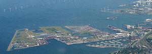
Aerial view of Nordhavn, before expansion
Nordhavnen, or Nordhavn, is a harbour area at the coast of the Øresund, founded at the end of the 19th century in Copenhagen, Denmark. It covers an area of more than 2 km².
Today, most of Copenhagen Harbour's traditional activities are situated in Nordhavn, including ferry berths, a container terminal, marina, and industrial companies.
The S-train station Nordhavn station is located at Nordhavnen close to the city district Østerbro.
Contents
1 Expansion of Nordhavn
2 Cultural references
3 See also
4 External links
5 References
Expansion of Nordhavn

Nordhavn viewed from Langelinie, after expansion
The agency By og Havn has started the 668 million DKK expansion of Nordhavn into Øresund. The project is the largest construction job in Denmark in 2013 and the largest consumer of steel in Northern Europe; 28,000 tonnes of steel is used for pile driving the sheet piles of the perimeter, and the area is being filled with 7 million tonnes of clean earth and 11 million tonnes of polluted earth from the City Circle Line metro and other projects until around year 2022-2025.[1] The City Circle Line is extending into Nordhavn with at least one station.[2]
The cruise ship quay is 1,100m long with 3 passenger terminals.[1]
The agency By og Havn has proposed plans to develop Nordhavn as a new city district that would have 40,000 residents and 40,000 jobs.[3][4] The proposed district will be about six times larger than Indre Østerbro.
The Municipality of Copenhagen plans to build 400,000 m² for residence and industry around Århusgade from 2008 onwards, and additional 200,000 m² at Kalkbrænderiløbet from 2015. The area is expected to be fully developed within 20–25 years and partially finances the expansion of the Copenhagen Metro.
In 2013, the United Nations campus UN City opened at the eastern part of Marmormolen in the Nordhavn area.[5] The 45,000 m² project will include most of the present UN activities in Copenhagen.[6][7]
Cultural references
Skudehavnsvej in Nordhavn is used as a location at (0:37:24 and 0:47:14 in the 1977 Olsen-banden film The Olsen Gang Outta Sight.[8]
See also
- Pakhus 48
- Portland Towers
External links
- Construction photos
- Aerial photos
References
^ ab Birgitte Marfelt. "Nordhavnen er på vej ud i sejlrenden" Ingeniøren, 31 August 2013. Accessed: 16 October 2013.
^ Birgitte Marfelt. "Uden udbud og anlægslov: Fuld gang i metro til Nordhavn" Ingeniøren, 4 June 2013. Accessed: 16 October 2013.
^ Nordhavnen
^ By & Havn Accessed: 21 October 2016
^ Marmormolen
^ Mie Stage. "Nu åbner Københavns stjerneformede FN-by" Ingeniøren, 3 June 2013. Accessed: 16 October 2013.
^ "Vedr. Århusgadekvarteret i Nordhavn" (PDF) (in Danish). Museum of Copenhagen. Retrieved 25 May 2015..mw-parser-output cite.citation{font-style:inherit}.mw-parser-output .citation q{quotes:"""""""'""'"}.mw-parser-output .citation .cs1-lock-free a{background:url("//upload.wikimedia.org/wikipedia/commons/thumb/6/65/Lock-green.svg/9px-Lock-green.svg.png")no-repeat;background-position:right .1em center}.mw-parser-output .citation .cs1-lock-limited a,.mw-parser-output .citation .cs1-lock-registration a{background:url("//upload.wikimedia.org/wikipedia/commons/thumb/d/d6/Lock-gray-alt-2.svg/9px-Lock-gray-alt-2.svg.png")no-repeat;background-position:right .1em center}.mw-parser-output .citation .cs1-lock-subscription a{background:url("//upload.wikimedia.org/wikipedia/commons/thumb/a/aa/Lock-red-alt-2.svg/9px-Lock-red-alt-2.svg.png")no-repeat;background-position:right .1em center}.mw-parser-output .cs1-subscription,.mw-parser-output .cs1-registration{color:#555}.mw-parser-output .cs1-subscription span,.mw-parser-output .cs1-registration span{border-bottom:1px dotted;cursor:help}.mw-parser-output .cs1-ws-icon a{background:url("//upload.wikimedia.org/wikipedia/commons/thumb/4/4c/Wikisource-logo.svg/12px-Wikisource-logo.svg.png")no-repeat;background-position:right .1em center}.mw-parser-output code.cs1-code{color:inherit;background:inherit;border:inherit;padding:inherit}.mw-parser-output .cs1-hidden-error{display:none;font-size:100%}.mw-parser-output .cs1-visible-error{font-size:100%}.mw-parser-output .cs1-maint{display:none;color:#33aa33;margin-left:0.3em}.mw-parser-output .cs1-subscription,.mw-parser-output .cs1-registration,.mw-parser-output .cs1-format{font-size:95%}.mw-parser-output .cs1-kern-left,.mw-parser-output .cs1-kern-wl-left{padding-left:0.2em}.mw-parser-output .cs1-kern-right,.mw-parser-output .cs1-kern-wl-right{padding-right:0.2em}
^ "Film 9 Olsen Banden deruda / Die Olsenbande schlägt wieder zu". olsenbande-homepage.de (in German). Retrieved 5 October 2017.
Coordinates: 55°42′58″N 12°36′22″E / 55.716°N 12.606°E / 55.716; 12.606
Copenhagen | |
|---|---|
See also: Urban area of Copenhagen | |
| Official districts |
|
| Notable localities and neighbourhoods |
|
| Parks and open spaces |
|
| Churches |
|
| Museums |
|
| Landmarks |
|
| Politics and administration |
|
| Education |
|
| Transport |
|
| |
| |


