West Hills, Los Angeles
| West Hills | |
|---|---|
| Neighborhood of Los Angeles | |
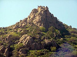 Escorpión Peak (aka: Castle Peak) (1,475 feet/450 m)—east face view from West Hills. | |
 West Hills as delineated by the Los Angeles Times | |
 West Hills Location within Los Angeles/San Fernando Valley Show map of San Fernando Valley  West Hills West Hills (the Los Angeles metropolitan area) Show map of the Los Angeles metropolitan area | |
| Coordinates: 34°12′14″N 118°37′44″W / 34.204°N 118.629°W / 34.204; -118.629 | |
| Country | United States |
| State | California |
| County | Los Angeles |
| City | Los Angeles |
| Owensmouth | 1912 |
| Canoga Park | 1930 |
| West Hills | 1987 |
| Area | |
| • Total | 8.53 sq mi (22 km2) |
| Elevation | 900 ft (274 m) |
| Population (2008)[1] | |
| • Total | 41,426 |
| • Density | 4,551/sq mi (1,757/km2) |
| Time zone | UTC-8 (PST) |
| • Summer (DST) | UTC-7 (DT) |
| ZIP code | 91304 & 91307 |
| Area code(s) | 818 & 747 |
West Hills is a residential and commercial neighborhood in the western San Fernando Valley region of Los Angeles, California.[2][3] The percentage of residents aged 35 and older is among the highest in Los Angeles County.[4]
The neighborhood was formerly the home of many Native American tribes, and during the early Spanish and Mexican era was part of the Mission San Fernando Rey de España. In the American era, West Hills was part of Owensmouth, which was renamed Canoga Park in 1930. West Hills was established in western Canoga Park and retained its present name in 1987.
Historic landmarks and many city parks are to be found within the community, as are commercial districts, a business district, and religious establishments. Two private high schools are among the 13 schools within West Hills.
Contents
1 Geography
1.1 Location
1.1.1 Mapping L.A.
1.1.2 Neighborhood Council boundaries
1.2 Water resources
2 Population
2.1 2010
2.2 2000
2.3 1980
3 History
3.1 Pre-Spanish contact history
3.2 Spanish and Mexican history
3.3 American history
3.3.1 Land grants
3.3.2 Separation from Canoga Park
4 Parks and landmarks
4.1 Landmarks
4.1.1 Orcutt Ranch
4.1.2 Shadow Ranch
4.2 Open-space parks
4.3 Neighborhood parks
4.4 Other historic-cultural landmarks
4.4.1 Francis Lederer Estate
4.4.2 Peppergate Ranch
5 Government representation and services
5.1 County of Los Angeles
5.1.1 Police and fire
5.1.2 Public library
5.1.3 West Hills Neighborhood Council
5.2 Federal
5.2.1 Representation
5.2.2 U.S. Postal Service
5.3 State
5.4 Los Angeles County
5.5 Los Angeles Unified School District
6 Hospitals
7 Education
7.1 Schools
7.1.1 Public
7.1.2 Private
7.1.3 Adjacent public schools
8 Other community features
8.1 Public transport
9 Notable residents
10 See also
11 References
12 External links
12.1 General
12.2 Photos
Geography
Location
West Hills (formerly joined with Canoga Park) is located in the West San Fernando Valley (SFV) in the county of Los Angeles and about 30 minutes (depending on traffic) from Downtown Los Angeles. It is off of the 101 Ventura freeway offramp Valley Circle Blvd/Mullholland Highway.
Mapping L.A.
According to the Mapping L.A. project of 2008, the Los Angeles Times, West Hills is flanked on the north by the Chatsworth Reservoir, on the east by Canoga Park, on the south by Woodland Hills, on the southwest by Hidden Hills and on the west by Bell Canyon in Ventura County.[5][6]
Neighborhood Council boundaries
In 1987, Los Angeles recognized the following description of the boundaries of West Hills Neighborhood Council:[5][6][7]
Starting at the centerline intersections of Topanga Canyon Boulevard and Nordhoff Street, westward down the centerline of Nordhoff extended in a straight line to the city limits of the City of Los Angeles; thence southward, following the border of the City of Los Angeles to the centerline of Victory Boulevard; thence eastward down the centerline of Victory Boulevard to Shoup Avenue centerline; thence northward down the centerline of Shoup Avenue to the intersection of the centerline of Roscoe Boulevard; thence eastward down the centerline of Roscoe Boulevard to the centerline of Topanga Canyon Boulevard; then northward down the centerline of Topanga Canyon Boulevard to the centerline of Nordhoff Street.[8]
Water resources
Bell and Dayton creeks in West Hills are several of the headwaters of the Los Angeles River that originate in the Northwest San Fernando Valley. The Los Angeles River itself begins at the confluence of Arroyo Calabasas (Calabasas Creek) and Bell Creek in Canoga Park. These and other small creeks supply stormwater and suburban runoff water to the Los Angeles River, and several are considered year-round creeks. Although the creeks are now channeled and run within concrete walls, they do form a significant urban wildlife landscape and contribute to the population of indigenous wildlife left within the San Fernando Valley.[citation needed]
Both Bell Creek and Dayton Creek in particular have received attention due to their headwaters origins inside the Santa Susana Field Laboratory in the Simi Hills. The SSFL is mandated for an environmental cleanup due to its uses as a testing center for rocket and missile engines, nuclear reactor research and fuel reprocessing, and high technology defense systems. It was also the site of a partial nuclear core meltdown in 1959.[9] Prominent contaminants include radionuclides, VOCs-volatile organic compounds, Chromium, Lead, Benzene, and other components of rocket engine fuel and cleaning compounds.[10][11]
This region experiences warm and dry summers with average temperatures peaking at 96 degree highs throughout August. West Hills has a climate similar to other locations in the west San Fernando Valley, such as nearby Woodland Hills with a long established weather station at Pierce College. According to the Köppen Climate Classification system, West Hills has a warm-summer Mediterranean climate, abbreviated "Csa" on climate maps.[12]
Population
2010
As of the 2010 census, and according to the Los Angeles Almanac, there were 38,814 people and 10,626 households residing in West Hills. The ethnic-racial medley of the neighborhood was 96.04% White, 2.04% Asian, 0.05% Pacific Islander, 1.11% African American, 0.36% Native American, 2.80% from other races, and 1.82% from two or more races. 3.26% of the population were Hispanic of any race.
2000
The Los Angeles Times reported that the 2000 U.S. census counted 30,814 residents in the 8.53-square-mile (22.1 km2) West Hills neighborhood,—or 4,551 people per square mile, among the lowest population densities for the city. In 2008, the city estimated that the population had increased to 41,426.[4]
In 2000 the median age for residents was 39, considered old for city and county neighborhoods; the percentages of residents aged 35 and older were among the county's highest.[13]
The neighborhood was considered "moderately diverse" ethnically within Los Angeles, with a high percentage of white residents. The breakdown was whites, 70.9%; Latinos, 11%; Asians, 11.3%; blacks, 2.5%; and others, 4.3%. Iran (13.8%) and the Philippines (8.4%) were the most common places of birth for the 22.7% of the residents who were born abroad—a low percentage for Los Angeles.[4]
The median yearly household income in 2008 dollars was $103,008, considered high for the city and county. The percentage of households that earned $125,000 and up was high for Los Angeles County. Renters occupied 12.6% of the housing stock, and house and condominium-owners occupied 87.4%.[4]
The percentages of married people were among the county's highest. In 2000 there were 785 families headed by single parents, a low percentage for both the city and the county.[4]
Eleven percent of the population were military veterans, a high rate for the city and the county, and the percentages of veterans who served during World War II or the Korean War were among the county's highest.[4]
1980
The 1980 census showed 32,370 people living in the area that later became West Hills, of whom 92% were white, 7% Hispanic, 1% black, 4% Asian and 3% other. Families constituted 90% of the population, and 72% of the residents owned or were buying their own homes. Fifty-three percent had attended college.[14]
History
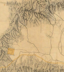
Detail of the southwestern San Fernando Valley, from an 1880 manuscript map of Los Angeles and San Bernardino topography, showing Rancho El Escorpión (shaded area).
Pre-Spanish contact history
The present day West Hills area was the homeland of Native Americans in the Tongva-Fernandeño and Chumash-Venturaño tribes, that lived in the Simi Hills and close to Bell Creek and other local tributaries to the Los Angeles River. Native American civilizations had inhabited the San Fernando Valley for an estimated 8,000 years.[15][16] The village, Hu'wam, of the Chumash-Venturaños, was located at the base of Escorpión Peak (Castle Peak) near present-day Bell Canyon Park.[17] It was a meeting and trading point for them with the Tongva-Fernandeño and Tataviam-Fernandeño people.[18] A cave near Hu'wam, known as the Cave of Munits, is the believed home of a mythical Chumash shaman named Munits, who was killed by an eagle after murdering the son of a Chumash chief.[19] Escorpión Peak is one of nine alignment points in the ancestral Chumash homelands, believed essential to maintaining the balance of the natural world.[20]
Spanish and Mexican history
From 1797 to 1846, the area (future West Hills) was part of Mission San Fernando Rey de España (Mission San Fernando). After Mexico won independence from Spain, it later became part of Rancho Ex-Mission San Fernando in Alta California. In 1845, a separate land grant for Rancho El Escorpión was issued by Governor Pío Pico to three Chumash people: Odón Eusebia, Urbano, and Urbano's son Mañuel.[21] It encompassed the land west of present-day Woodlake Avenue in West Hills, with its adobe ranch buildings (present 1840s—1960s) sited beside Bell Creek near present-day Bell Canyon Park.[22][23]
American history
Land grants
California was admitted to the United States in 1850, with Spanish and Mexican land grants requiring a federal land patent to retain ownership.[24] The United States Public Land Commission patented the Rancho to original grantees Odón Eusebia, Urbano, and Mañuel in 1876.[25][26] In 1912 the Chumash heirs sold Rancho El Escorpión to George Platt. He established a dairy operation on renamed Platt Ranch variously called Ferndale, ‘escorpion,’ or Cloverdale Dairy.[27] The Rancho El Escorpión-Platt Ranch was not incorporated into Los Angeles and its water system until 1958 and was left undeveloped until 1961.
Separation from Canoga Park
West Hills was originally part of Owensmouth (founded 1912) and renamed Canoga Park (1931).[28]
| “ | There's a community identity that didn't previously exist, a forum for people to be involved in community affairs. | ” |
— Joel Schiffman, West Hills Property Owners Association[29] | ||
Under the leadership of Joel Schiffman, residents of a three-square-mile area in western Canoga Park began a petition campaign in 1987 to separate from the larger community and establish a neighborhood of their own to be called West Hills, the same name that a 303-home subdivision in a nearby unincorporated area had carried for years. The Los Angeles city district of 4,700 single-family homes and 35 businesses would be bounded by Roscoe Boulevard on the north, Woodlake Avenue, Sherman Way and Platt Avenue on the east, Victory Boulevard on the south and the county line on the west. Proponents said the change would give the area "political clout" and increase property values. The drive, which was opposed by the Canoga Park Chamber of Commerce, was partially financed by a real estate firm, whose owner, Lynn Garvanian, said the name change would "add 5% to the value of homes." The campaign was quickly criticized as "snobby and greedy" by members of the Canoga Park Chamber of Commerce but defended by supporters who said it would allow the neighborhood to preserve its residential character.[30][31] Petition leaders said they hoped a new name would separate the more affluent West Hills area from Canoga Park's "fading factories, aging subdivisions and X-rated bars and theaters."[29]
| “ | They're looking for the betterment of a community by renaming it. There's no magic in words. | ” |
— William F. Vietinghoff, Canoga Park Chamber of Commerce.[32] | ||
As the petition drive expanded to include three more areas – two on the edge of the Chatsworth Reservoir and one on the western edge of Canoga Park – the Canoga Park Chamber of Commerce took an official stand against the separation, with president William Vietinghoff calling it "a source of division and disharmony . . . an extremely dangerous precedent for the whole San Fernando Valley." Council member Hal Bernson, however, said he did not "look at it as a slam against Canoga Park – just as a group of people wanting identity."[33]
On January 16, 1987, Councilwoman Joy Picus accepted petitions representing 3,364, or 77% of the 4,333 households in the area within her councilmanic district, and she immediately said she would direct the city's transportation department to put up boundary signs as the residents requested.[29] Many of the latter expected the name change to add thousands of dollars of value to their properties.[34] Two weeks later Picus added another two-mile-wide section of Canoga Park that gave West Hills the Fallbrook Mall and Platt Village shopping centers, along with several smaller retail strips and some older residential tracts built in flatland areas. This addition was denounced by Schiffman, who said it did "a lot to erode the community identity we sought."[34]
| “ | . . . no further petitions. I didn't know this was going to grow. I just want this to go away. | ” |
— Joy Picus, City Council member[34] | ||
In what was called a "stampede,"[35] other areas sought entry into West Hills, one homeowner on Santa Susana Place saying residents there wanted to "divorce ourselves from Canoga Park's element."[34] Council member Hal Bernson agreed to add a square-mile area with 423 households bounded by Roscoe Boulevard on the south, Parthenia Street on the north, Shoup Avenue on the west and Topanga Canyon Boulevard on the east, although the commercial northwest corner of Roscoe and Topanga Canyon boulevards was to remain in Canoga Park. Those additions meant that from nearly a third to nearly half of the former Canoga Park was to be part of the new West Hills.[14][32]
Still, a demand continued for admittance to West Hills.[35] A community meeting scheduled for August 31, 1987, had to be repeated later the same evening when some four hundred people packed a meeting room at the Fallbrook Mall to wrestle with the decision on where the final boundary should be. The later event drew three hundred.[35] A poll was taken among about 8,500 residents in an area between Topanga Canyon Boulevard and the recently adopted West Hills border at Woodlake and Platt avenues to choose an eastern border. More than a hundred protestors gathered in front of Picus's office to protest any enlargement of West Hills, chanting "Hell, no, we won't grow!" But other residents wound through the area in car caravans, shouting from megaphones and waving signs urging "Vote to Fallbrook."[36] In the end, Picus made a controversial decision to move the eastern boundary of West Hills from Platt and Woodlake avenues to Shoup Avenue, a decision that did not please everybody.[37]
In 1994, the Canoga Park and West Hills communities achieved a "partial rapprochement" when business leaders voted to form a united Canoga Park/West Hills Chamber of Commerce,[38] which is still in existence.
Parks and landmarks
Three ranches and a silent film star's estate in West Hills have been awarded Los Angeles Historic-Cultural Monument status recognition and protection, and two are city parks. In addition, on the western edge of West Hills huge open space preserves provide an undeveloped greenbelt and nearby recreation opportunities. The high number of neighborhood parks here offer sports fields and courts, play areas for children, and community rooms.
Landmarks
Orcutt Ranch
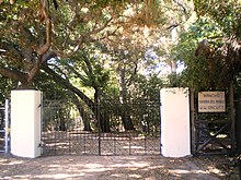
Orcutt Ranch native oaks and entry gates
Orcutt Ranch Estate, ("Rancho Sombra del Roble") to the Orcutts, is the 1920 adobe residence, gardens, and citrus orchards of William Warren Orcutt, an early Union Oil Company executive.[39] The park has an entry through craftsman style stone gates to a parking area with natural habitat landscaping on Roscoe Boulevard near Valley Circle Boulevard. The park, now named the Orcutt Ranch Horticulture Center, offers: self-guided strolling, exploring and scheduled house tours;[40] public community gardens;[41] annual public citrus harvests;[42] and garden wedding and special event facilities.[43] Orcutt Ranch is a registered-protected Los Angeles Historic-Cultural Monument.
Shadow Ranch

Shadow Ranch ranch-house and Park
Shadow Ranch Park, formerly the Workman Ranch, on Vanowen Street just east of Fallbrook Avenue. Alfred Workman was a muleskinner who emigrated from Australia, winding up running a massive wheat farm owned by a syndicate led by Isaac Lankershim and Isaac Van Nuys. He bought the ranch in 1869, and from then to 1872, Workman built a home for his wife, Henrietta Feliz, and himself by adding onto an existing adobe. The Australian had eucalyptus trees imported and planted on the ranch, and some folks claim all the eucalyptus trees in California stem from Workman Ranch. Workman Ranch was acquired by a married, screenwriting couple, Colin Clements and Florence Ryerson (the latter co-wrote the screenplay for The Wizard of Oz while living here). She renamed the estate Shadow Ranch for the amount of shade provided by the numerous eucalyptus trees planted by Workman decades ago. William Wyler’s movie The Children’s Hour, based on the play by Lillian Hellman, was filmed here in 1961.[44]Shadow Ranch Park is an L.A. City Park with lighted basketball courts, a children's play area, football and soccer fields, meeting and community rooms, a baseball diamond, and picnic tables. Organized youth sports are also offered at this registered-protected Los Angeles Historic-Cultural Monument[45]
Open-space parks
All of these large Parks are open for walks, hiking, mountain biking, and equestrian riding; sunrise to sunset.
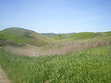
Rolling hills at Upper Las Virgenes Canyon
El Escorpión Park: The area landmark El Escorpión Peak centered in the park offers hikes with impressive views of the Valley. The trailhead and parking are at the western end of Vanowen Boulevard, west of Valley Circle Boulevard (Castle Peak Park).[46]
Bell Canyon Park is directly adjacent on the northwest of El Escorpión Park, with trails along natural Bell Creek and up the north side of the Peak. The trailheads and parking are off Bell Canyon Boulevard just before the 'Bell Canyon community' gatehouse, west of Valley Circle Boulevard. Pedestrian access follows up the creek past the gated road to later loop around the Peak to El Escorpión Park.[47]
Upper Las Virgenes Canyon Open Space Preserve parking and trailheads are at the western end of Victory Boulevard, west of Valley Circle Boulevard. Trails cross the huge natural park and connect west to adjoining Cheseboro-Palo Comado Canyon Park section of the Santa Monica Mountains National Recreation Area, north to El Escorpión and Bell Canyon Parks, and south to Hidden Hills, creating a generous greenbelt for West Hills. There are also scheduled evening moonlight hikes, and daytime events.[48]
Roscoe/Valley Circle Park is a rustic linear open space park with panoramic views and an equestrian trail, west of Valley Circle Blvd. with access at Roscoe Boulevard, at West Stagg Street, and at Quiet Hills Court.[49]
Neighborhood parks

Mae Boyar Recreation Center and Castle Peak as seen from Highlander Road School, 1978.
- Knapp Ranch Park has two sections: Kittridge Avenue east section offers these outdoor unlighted sports facilities: baseball diamond, basketball courts, a children's play area, picnic tables, and tennis courts; Wooded Vista and Twisted Oak Drive west section offers walks, a picnic area, and panoramic views.[50]
- The West Hills Sports Center/Adam Bischoff Soccer Fields has a pocket park, recreation center, and soccer fields. It is on the west side of Valley Circle Blvd. near Vanowen.[51]
- Mae Boyar Recreation Center has basketball courts and a playground, on Highlander Rd.[52]
- Taxco Trails Park is a pocket park, with a children's play area and picnic tables on Platt Ave. and Saticoy.[53]
- Lazy J Ranch is a pocket park, with a children's play area on Valley Circle Blvd.[54]
- Chase Park has a children's play area and picnic tables.[55]
- Hidden Lake Park, a neighborhood park at Lees Lake, Sedan Ave. off Roscoe Boulevard, directions at gate.
- Castle Peak Park is a small neighborhood open space park for picnics on Valley Circle Blvd., (not to be confused with El Escorpión [Peak] Park).[56]
- Four Oaks Park is a neighborhood pocket park, with a children's play area and picnic tables, on Cohasset and Melba Ave.[57]
Other historic-cultural landmarks
Francis Lederer Estate
The Lederer Estate, of stage actor and early film star Francis Lederer (1899–2000), has two separate structures and their settings that are each a registered Los Angeles Historic-Cultural Monument—LAHCM. These are: the former residence and its outdoor patio rooms, gardens, and grounds; and the equestrian stables and its patios. Lederer was the honorary Mayor of Canoga Park (pre-West Hills) for many years. In retirement he taught theatre classes, and was a member of the L.A. City Parks Board of Directors. The landmark buildings are located west of and near the West Hills Post Office and West Hills Hospital.
Francis Lederer Residence — LAHCM No. 204, a very distinguished residential example of the Mediterranean Revival, Spanish Colonial Revival, and Mission Revival styles of architecture integrated together, with the interior and exterior design and artisan detailing of museum quality.[58] The house was begun in 1934 and constructed over a period of years, with artisan builder John R. Litke, by Lederer on his then 300-acre Canoga Park ranch. It sits atop a hill overlooking the Valley and surrounding mountains.
The exterior walls use stone quarried from the site. The residence wraps around a large central courtyard with a fountain and outdoor fireplace, and the various rooms opening onto it. The materials were chosen with care and painstakingly employed in such a manner as to make the resulting structure appear very old. The imported Spanish and Italian furnishings and artworks are of particular interest, dating from the 14th to 19th centuries. The estate's residence was to become a public museum housing the Canoga-Owensmouth Historical Society, a community arts center, and its gardens and open space a city park; however it is currently for sale by the heirs (2013).[59][60]
Francis Lederer Stables — LAHCM No. 135, designed and built in a rustic and authentic Mission Revival architectural style. It was also designed by Francis Lederer and John R. Litke in 1936 and used locally quarried stones.[61] It was originally on the natural bank of free-flowing Bell Creek, before its channelization in the late 1950s.[62] Through Mrs. Lederer's efforts in the 1970s, the stables opened to the community as the Canoga Mission Gallery—now the Hidden Chateau event venue, on western Sherman Way.[63]
Peppergate Ranch
The 29-acre (120,000 m2) Peppergate Ranch was located between Orcutt Ranch and Chatsworth Reservoir. The ranch's residence was designed by master architect Paul R. Williams (1894–1980) in the Ranch Style.[64] It was built in 1939 for Talton R. Craig, founder of the Craig Movie Supply Company. The T.R. Craig Residence is a Los Angeles Historic-Cultural Monument (#992) (in 2011), located on Pinelake Drive. Peppergate Ranch was subdivided, as Woodlake Estates and Pinelake Estates, in the 1960s.[65]
Government representation and services
County of Los Angeles
West Hills, formerly known as Canoga Park, is located within the City of Los Angeles’ 12th City Council District — represented by Councilmember Mitchell Englander[66]. It borders the cities of Calabasas, Woodland Hills, and Canoga Park all located within the San Fernando Valley in California.
Police and fire
Los Angeles Police Department — West Hills is served by the LAPD Topanga Community Station, located in adjacent Canoga Park.[67][68][69]
The LAPD named the station after a historical village of the local Tongva—Fernandeño Native American tribe, using a westernized version of its Tongva language name. It was originally to be named the Northwest Station, however local residents preferred a name reflecting the region's history.[70] The new complex opened at 21501 Schoenborn Street (91304) in 2008.
Los Angeles Fire Department — West Hills is served by LAFD Station 106 in West Hills,[71] and LAFD Station 105 in Woodland Hills (Fallbrook and Victory).[72]
Public library
The Los Angeles Public Library operates the Platt Branch Library at 23600 Victory Boulevard. In 2015, the Neighborhood Councils of West Hills and Woodland Hills-Warner Center agreed to share jurisdiction over the library and its grounds, making it a part of both West Hills and Woodland Hills.[73]
West Hills Neighborhood Council
The West Hills Neighborhood Council (WHNC) has a website, public meetings, and sponsors events and activities. It is governed by a 25-member board of directors that is elected by West Hills stakeholders (residents and local business owners). The council also is a resource as the city's official forum for individuals and the community to learn about, discuss and take positions on local and citywide issues.[74]
Federal
Representation
- West Hills is represented in the United States Senate by California's Senators Dianne Feinstein and Kamala Harris.[75]
- West Hills is within the 30th Congressional district — represented by U.S. Representative Brad Sherman.[76]
U.S. Postal Service
The United States Postal Service: The West Hills Post Office is located at 23055 Sherman Way, West Hills, 91307 (where Platt turns into Sherman Way.[77] The community's postal zip code is 91307.
State
West Hills is within the:
27th State Senate district — represented by State Senator Henry Stern[78]
45th State Assembly district — represented by Assemblymember Matt Dababneh, completing the term vacated by Bob Blumenfield to represent Los Angeles City Council District 3 (Canoga Park/Woodland Hills).[79]
[80]
Los Angeles County
West Hills is divided within two Districts of the Los Angeles County Board of Supervisors.
- Los Angeles County Third District — represented by Supervisor Sheila Kuehl (south of Saticoy).[81]
- Los Angeles County Fifth District — represented by Supervisor Michael D. Antonovich (north of Saticoy) [82]
Los Angeles Unified School District
Los Angeles Unified School District (LAUSD), Board of Education District 3, represented by Tamar Galatzan.[83]
Hospitals
The West Hills Hospital and Medical Center, located at Medical Center Drive and Sherman Way, serves the local community as well as patients from several cities in Los Angeles and Ventura Counties.[84] The West Hills Hospital Surgical Center opened in 1996, and performs procedures in specialties such as general and hand surgery (done by The Hand Center of Southern California), gynecology, gastroenterology, and orthopedics.[85] The West Hills Hospital and Medical Center facilities also include a large maternity ward and an oncology unit. The Grossman Burn Centers, formerly based at Sherman Oaks Hospital, moved to West Hills Hospital in 2010.[86] This hospital (originally opening in 1984) is not a trauma center so any trauma/emergency cases are routed nearby to Northridge Hospital.
Education

Welby Way Elementary School
Thirty-eight percent of West Hills residents aged 25 and older had earned a four-year degree by 2000, a high percentage for both the city and the county. The percentages of those residents with a master's degree or higher was also high for the county.[4]
Schools
Schools within the West Hills boundaries are:[87][88]
Public
The Los Angeles Unified School District operates public schools in this area.
- Capistrano Avenue Elementary School, 8118 Capistrano Avenue
- Enadia Way Elementary School (Enadia Technology Enriched Charter School), 22944 Enadia Way
- Hamlin Street Elementary School (Hamlin Charter Academy), 22627 Hamlin Street
- Haynes Elementary School, 6624 Lockhurst Drive
- Justice Street Elementary School, 23350 Justice Street
- Nevada Avenue Elementary School, 22120 Chase Street
- Pomelo Drive Elementary School, 7633 March Avenue
- Welby Way Elementary School, 23456 Welby Way
State charters:
- Ivy Academia Entrepreneurial Charter High School, 7353 Valley Circle Boulevard
Private
New Community Jewish High School, 22622 Vanowen Street
Chaminade College Preparatory, high school, 7500 Chaminade Avenue- Parkhill School, 7401 Shoup Avenue
- Crane Academy of Excellence, K-12, 23119 Vose Street
- Kadima Day School, 7011 Shoup Avenue
- Shepherd of the Valley Lutheran, preschool, 23838 Kittridge Street
- West Valley Christian School, 22450 Sherman Way
Adjacent public schools
Public middle schools and high schools serving West Hills within their district boundary lines include:
- Hale Middle School—George Ellery Hale Charter Academy (Woodland Hills) [89]
- Christopher Columbus Middle School (Canoga Park) [90]
Canoga Park Senior High School (Canoga Park)
Chatsworth Senior High School—Chatsworth Charter High School (Chatsworth)
El Camino Real Senior High School—El Camino Real Charter High School (Woodland Hills)- Ivy Academia Entrepreneurial Charter School Tk-6 (Woodland Hills)
Other community features
Among religious buildings, Our Lady of the Valley Catholic Church, Saint Bernardine Parish and the Shomrei Torah Synagogue is located near Stone Gate Drive and Valley Circle Boulevard. Chabad of West Hills is located near the intersection of Hartland Street and Valley Circle Boulevard.
The Corporate Pointe business park, on the largest research and light industry property in West Hills, is in planning for redevelopment.[91] It is located at Fallbrook Avenue and Roscoe Boulevard, near Hidden Lake and the Chatsworth Reservoir. The property was originally developed in 1959 as the Thompson-Ramo-Wooldridge aerospace corporation's new headquarters. It was later used by Atomics International, Hughes Aircraft, and Raytheon for aerospace development advancements and nuclear research.[92][93]
Public transport
Public transport within West Hills and the San Fernando Valley is provided by Metro Local bus routes, operated by the Los Angeles County Metropolitan Transportation Authority (Metro). They connect to transfer points and hubs in adjacent Woodland Hills, Canoga Park, and Chatsworth for other public transport systems and destinations.
Metro Local routes serving West Hills include: 162/163 via Sherman Way, 164 via Victory Boulevard, 165 via Vanowen Street, 169 via Saticoy Street, and 152/353 via Fallbrook Avenue and Roscoe Boulevard.
- Orange Line
Metro Local buses connect with the Orange Line at nearby stations to the east in Canoga Park, including the Canoga Station, Sherman Way Station, and Roscoe Station.[94][95] The southeastbound Orange Line connects to the North Hollywood Metro Station for the Red Line subway to Downtown Los Angeles and beyond. The northbound Orange Line connects to the Chatsworth Station Transportation Center, a hub for: the Amtrak Pacific Surfliner trains; the Metrolink Ventura County Line trains; and the buses of the Los Angeles Department of Transportation (LADOT) Downtown Commuter Express, Simi Valley Transit, and Santa Clarita Transit.
Notable residents
Sue Alexander (1933–2008) – children's author[96]
Mitchell Englander (born 1970), member of the Los Angeles City Council
America Ferrera — actress
Frank Kelly Freas — science fiction illustrator
Blake Gailen (born 1985) – baseball player[97][98]
Jesse James Hollywood – convicted of kidnapping and murder[99]
Illana Katz — author, lecturer, and founder of Real Life Storybooks
Natalie Kingston—actress
Francis Lederer — actor, early film star, civic leader
Miguel Leonis — 19th century owner of Rancho El Escorpión
Wendy Liebman (born 1961), stand-up comedian
Nicholas Markowitz — victim in Jesse James Hollywood kidnapping-murder case
Bob Miller (sports announcer) — play-by-play broadcaster
Christopher Mintz-Plasse — actor
Daniella Monet — actress
Daniel Olivas — author, book critic, attorney
Bryce Papenbrook (born 1986), voice actor
Kevin Pillar — professional baseball outfielder[100]
Mark Saul — actor
See also
- Rancho El Escorpión
- Owensmouth (Pacific Electric)
- Burro Flats Painted Cave
- Rock art of the Chumash people
- History of the San Fernando Valley to 1915
References
^ "West Hills". Mapping L.A..mw-parser-output cite.citation{font-style:inherit}.mw-parser-output q{quotes:"""""""'""'"}.mw-parser-output code.cs1-code{color:inherit;background:inherit;border:inherit;padding:inherit}.mw-parser-output .cs1-lock-free a{background:url("//upload.wikimedia.org/wikipedia/commons/thumb/6/65/Lock-green.svg/9px-Lock-green.svg.png")no-repeat;background-position:right .1em center}.mw-parser-output .cs1-lock-limited a,.mw-parser-output .cs1-lock-registration a{background:url("//upload.wikimedia.org/wikipedia/commons/thumb/d/d6/Lock-gray-alt-2.svg/9px-Lock-gray-alt-2.svg.png")no-repeat;background-position:right .1em center}.mw-parser-output .cs1-lock-subscription a{background:url("//upload.wikimedia.org/wikipedia/commons/thumb/a/aa/Lock-red-alt-2.svg/9px-Lock-red-alt-2.svg.png")no-repeat;background-position:right .1em center}.mw-parser-output .cs1-subscription,.mw-parser-output .cs1-registration{color:#555}.mw-parser-output .cs1-subscription span,.mw-parser-output .cs1-registration span{border-bottom:1px dotted;cursor:help}.mw-parser-output .cs1-hidden-error{display:none;font-size:100%}.mw-parser-output .cs1-visible-error{font-size:100%}.mw-parser-output .cs1-subscription,.mw-parser-output .cs1-registration,.mw-parser-output .cs1-format{font-size:95%}.mw-parser-output .cs1-kern-left,.mw-parser-output .cs1-kern-wl-left{padding-left:0.2em}.mw-parser-output .cs1-kern-right,.mw-parser-output .cs1-kern-wl-right{padding-right:0.2em}
^ [1] Median household income is "high for the city of Los Angeles and high for the county." "Mapping L.A.," Los Angeles Times.
^ "San Fernando Valley," Mapping L.A.
^ abcdefg "West Hills". Mapping L.A.
^ ab [2] Colored map, Mapping L.A., Los Angeles Times
^ ab The Thomas Guide: Los Angeles County, Rand McNally (2004), pages 529 and 531
^ [3] Bing maps
^ "Westhillsnc.org".
^ "DTSC - Santa Susana Field Laboratory Site Investigation and Cleanup - HOME". www.dtsc-ssfl.com.
^ "ACME". acmela.org.
^ "SSFL public forum".
^ Western Region Climate Center http://www.wrcc.dri.edu/cgi-bin/cliMAIN.pl?ca1484. Retrieved November 1, 2016. Missing or empty|title=(help)
^ "Mapping L.A.: West Hills". Los Angeles Times.
^ ab Patricia Klein, "Longtime Residents of Canoga Park Say They Stand by Their Community Despite the Stinging Defection of Affluent West Hills," Los Angeles Times, July 12, 1987, page 6
^ "USATODAY.com - Prehistoric milling site found in California". www.usatoday.com.
^ "Mercury News article".
^ "SSPSHP Ethnohistory" (PDF).
^ "Ahmanson Ranch Becomes Private Preserve", Wishtoyo Foundation website Wishtoyo.org. accessed October 23, 2007
^ Harrington, John P. 1986. Southern California/Basin. Ethnographic Field Notes, Pt. 3. National Anthropological Archives, Smithsonian Institution, Washington, D.C. (Microfilm edition, Kraus International Publications, Millwood, N.Y. Rl. 106, Fr. 152
^ "Wishtoyo on Ahmanson Ranch".
^ Ogden Hoffman, 1862, Reports of Land Cases Determined in the United States District Court for the Northern District of California, Numa Hubert, San Francisco
^ "Oviatt Library Digital Collections".
^ Library of Congress—Historical American Buildings Survey (HABS): Rancho Escorpion adobe and setting — Directory of 1937 photographs and historical description . accessed 11.01.2013
^ 46th United States Congress, 1880, House Executive Document 46, pp. 1116–1117
^ "Report of the Surveyor General 1844 – 1886" (PDF).
^ "Finding Aid to the Documents Pertaining to the Adjudication of Private Land Claims in California, circa 1852-1892". content.cdlib.org.
^ "COHS". www.co-hs.org.
^ Gabe Fuentes, "Museum Recalls Era When It Was Chic to be Named Canoga Park," Los Angeles Times, San Fernando Valley edition, October 11, 1987, page 7
^ abc Patricia Klein, "West Hills Idea Fits Picus to a T-Shirt as She Puts a Chunk of Canoga Park on Map," Los Angeles Times, January 17, 1987, page V-6
^ Bob Pool, "Canoga Park Identity Crisis," Los Angeles Times, October 14, 1986, page 6
^ "Canoga Park C of C Resists 'West Hills' Separatists," Los Angeles Times, November 14, 1986, page V-6
^ ab Patricia Klein, "Latest Addition to West Hills Called Its Last," Los Angeles Times, February 11, 1987, page V-6
^ Bob Pool, "Canoga Park Secessionists: 2 More Areas Enlist in 'West Hills' Campaign," Los Angeles Times, San Fernando Valley edition, December 16, 1986, page 6 (with map)
^ abcd Bob Pool, "West Hills Still Growing in Leaps and Boundaries," Los Angeles Times, February 4, 1987, page V-A-6
^ abc Patricia Klein, "Overflow Crowd Exhorted to Join West Hills," Los Angeles Times, September 1, 1987, page VY-A-6
^ Gabe Fuentes, "Picus Clashes With West Hills Founders," Los Angeles Times, September 23, 1987, page J-6
^ Gabe Fuentes, "Picus Unveils New Map of West Hills, Calls It Final," Los Angeles Times, October 15, 1987
^ Jill Leovy, "Canoga Park, West Hills: 2 Chambers of Commerce Merge," Los Angeles Times, San Fernando Valley editions, January 13, 1994, page 2
^ "Orcutt Ranch Horticulture Center Rancho Sombra del Roble History." City of Los Angeles. Retrieved on March 22, 2010.
^ "Horticulture Centers and Gardens - City of Los Angeles Department of Recreation and Parks". www.laparks.org.
^ "Orcutt Ranch Horticulture Center Rancho Community Garden." City of Los Angeles. Retrieved on March 22, 2010.
^ "Horticulture Centers and Gardens - City of Los Angeles Department of Recreation and Parks". www.laparks.org.
^ "Orcutt Ranch Horticulture Center Rancho Sombra del Roble Special event and Wedding Rental." City of Los Angeles. Retrieved on March 22, 2010.
^ "Historic - City of Los Angeles Department of Recreation and Parks". www.laparks.org.
^ "Historic - City of Los Angeles Department of Recreation and Parks". www.laparks.org.
^ "Castle Peak Park." City of Los Angeles. accessed on March 20, 2010 El Escorpión Park.
^ "Bell Canyon Park." City of Los Angeles. accessed on March 20, 2010 Bell Canyon Park.
^ Lamountains.com, accessed 4/01/2010 Upper Las Virgenes Cyn. Park Events
^ "Roscoe/Valley Circle Park." City of Los Angeles. Retrieved on March 20, 2010.
^ "Knapp Park." City of Los Angeles. Retrieved on March 20, 2010.
^ "West Hills Sports Center/Adam Bischoff Soccer Fields." City of Los Angeles. West Hills Sports Center. retrieved on March 20, 2010.
^ Mae Boyar Recreation Center, accessed April 4, 2010.
^ "Taxco Trails Park." City of Los Angeles. Retrieved on March 20, 2010.
^ "Lazy J. Park." City of Los Angeles. Retrieved on March 20, 2010.
^ "Chase Park." City of Los Angeles. Retrieved on March 20, 2010.
^ Castle Peak Park. accessed April 4, 2010
^ "Four Oaks Park." City of Los Angeles. Retrieved on March 20, 2010.
^ Big Orange Landmarks: Los Angeles Historic-Cultural Monument No. 204 . accessed 11.01.2013
^ 23132shermanway.com: Prudential Realty; 23132 Sherman Way, West Hills, CA 91307 — with interior/exterior images slide show . accessed 11.01.2013
^ L.A. Curbed: "Buy the Amazing Mission-Style Lederer Residence in West Hills" . accessed 11.01.2013.
^ Big Orange Landmarks: Los Angeles Historic-Cultural Monument No. 135; 23130 Sherman Way, West Hills 91307 . accessed 11.01.2013
^ "SFVHS: Lederer".
^ Canoga Mission Gallery - Hidden Chateau website. accessed: 5.05.2010
^ "Paul Revere Williams: T.R. Craig (Harris) Residence – Photo gallery and history".
^ "L.A. Office of Historic Resources; "Newsletter"; April 2011" (PDF).
^ http://navigatela.lacity.org/common/mapgallery/pdf/council_districts/CDindex_8.5_11.pdf%7Ctitle=Map of LA CITY COUNCIL Districts
^ LApdonline.org: Los Angeles Police Department, Topanga Community Station; Telephone: 818-756-4800; 21501 Schoenborn Street, Canoga Park 91304 . accessed 11.1.2013.
^ Topanga Community Station Telephone Directory . accessed 11.01.2013.
^ "West Hills". Mapping L.A.
^ Vives, Ruben. LAtimes.com: "LAPD opens new station in Canoga Park" . Los Angeles Times . January 4, 2009 . Retrieved on April 26, 2009.
^ LAFD.org: Los Angeles Fire Department Station 106 . Retrieved December 6, 2008.
^ LAFD.org: Los Angeles Fire Department Station 105 . Retrieved December 6, 2008.
^ Platt Branch Los Angeles Public Library website . accessed 11.01.2013.
^ "Westhillsnc.org: West Hills Neighborhood Council—WHNC".
^ California Senators accessed March 19, 2017
^ Bradsherman.house.gov: official U.S. Congressman Brad Sherman website . D-30th Congressional District . accessed September 18, 2013.
^ Post Office Location – West Hills. United States Postal Service. Retrieved on December 6, 2008.
^ Senate.ca.gov: 27th State Senate district — Fran Pavley . accessed September 18, 2013
^ Official Website: Assemblymember Matt Dababneh — representing the 45th California Assembly District . accessed 02.14.2014.
^ "Senator Henry Stern". Senator Henry Stern.
^ LAcounty.gov: Los Angeles County Third District; Supervisor Zev Yaroslavsky . accessed 11.1.2013.
^ Antonovich.com: Los Angeles County Fifth District; Supervisor Michael D. Antonovich . accessed 11.1.2013.
^ LAUSD—Los Angeles Unified School District 3: Tamar Galatzan . accessed 11.1.2013.
^ Westhillshospital.com West Hills Hospital website. Accessed on December 6, 2007.
^ Westhillssurgicalcenter.com: West Hills Surgical Center website . Accessed on December 6, 2007.
^ Hsu, Tiffany (September 2, 2009). "Grossman Burn Center headed for West Hills Hospital" – via LA Times.
^ [4] "West Hills: Schools," Mapping L.A., Los Angeles Times
^ "GreatSchools: See what school district you are in or moving to using our interactive map". See What School District You Are In.
^ Woodland Hills Patch: Hale Middle School . accessed 11.01.2013
^ "Columbus Middle School". cms-lausd-ca.schoolloop.com.
^ Corporatepointeatwesthills.com: Site plan
^ "Corporate Pointe Gallery". July 19, 2009.
^ ACMELA.org, Historic photos & story
^ Los Angeles Metro Orange Line: Route and stations Map . accessed 11.01.2013
^ Los Angeles Metro Orange Line: Timetable . accessed 11.01.2013
^ Noland, Claire (14 July 2008). "Author of 'Nadia the Willful,' other children's books". Los Angeles Times. Retrieved 4 July 2017.
^ Blake Gailen Bio, UNLVRebels.com
^ "Obituaries-Charlene Gailen", Glendale News-Press, July 7, 2006.
^ "Middle-class Valley suburb unlikely breeding ground for a killer". Los Angeles Daily News. July 13, 2009.
^ "Kevin Pillar Stats, Fantasy & News". MLB.com. Retrieved December 27, 2016.
External links
| Wikimedia Commons has media related to West Hills, Los Angeles. |
General
[5] Canoga Park-West Hills Chamber of Commerce
[6] LAtimes.com: "Living in West Hills"
[7] Orcutt Ranch Park website
[8] Shadow Ranch Park website
[9] Upper Las Virgenes Canyon Park website
[10] West Hills Neighborhood Council
Photos
[11] Canoga Mission Gallery—Lederer Stables photos
[12] Digital Collections-CSUN: Rancho El Escorpion photos
[13] Lederer Residence photos
[14] Orcutt Ranch photos
[15] Shadow Ranch photos
Los Angeles city areas within the San Fernando and Crescenta Valleys | ||
|---|---|---|
| Districts and neighborhoods |
|  |
| Points of interest |
| |
| Neighboring cities and communities |
| |
| ||
| By topic |
|  |
|---|---|---|
| Government |
| |
| ||
Coordinates: 34°12′23″N 118°38′20″W / 34.20639°N 118.638959°W / 34.20639; -118.638959


