幸福湖
body.skin-minerva .mw-parser-output table.infobox caption{text-align:center}
| 幸福湖 | |
|---|---|
 | |
| 纬度 | 19.0°N |
| 经度 | 5.0°E |
| 直径 | 90 公里 |
| 命名来源 | 幸福湖 |


艾娜月坑,左上是达格陨石坑;左下为奥萨马陨石坑;艾娜月坑内右侧是较大的阿格妮丝山,图片宽度为3.5公里。

阿波罗17号拍摄的艾娜月坑照片(中间)
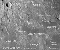
幸福湖及周边地区图
幸福湖又译为菲里斯塔迪斯湖(Felicitatis)是位于月球正面澄海、汽海和雨海间三角状的雪陆内,一小片已被熔岩流淹没、且反照率较周边地形更低的平坦区,尺寸约100公里。该湖名首次出现于1974年发表的美国军事测绘局为美国宇航局绘制的月图上[1]
,1976年被国际天文学联合会批准采纳[2][3]。
目录
1 位置和附近特征
2 描述
3 参考资料
4 外部链接
位置和附近特征
幸福湖的中心点月面坐标为北纬18.5°、东经5.4°[2],东北与怨恨湖接壤、东南毗邻忧伤湖、南面是汽海、西侧是忠诚湾。幸福湖东北70-80公里处是绵延的海玛斯山脉(一道环澄海盆地的山脊),西北100公里则是亚平宁山脉(类似的环雨海盆地山脊),幸福湖南面是位于汽海边缘直径8公里的扬格利陨石坑,幸福湖东北岸附近是直径6公里的卫星坑"科农 A"[4]。
描述
幸福湖的形状像一支二端分别指向西北和东面的回旋镖,东西约100公里,西北长140公里,终点处不太清晰。湖表高度低于月表基准0.3-1.1公里。
它是位于直径50公里,已被熔岩填塞且严重损毁的卫星坑"曼尼里乌斯 E"东面的三座月湖之一。月湖中央从北至南延伸着一条30公里宽、200-600米高[5][6][7]的细长高原(地垒),
该高原上坐落着一座300米高,直径17公里的月丘,可能是一座古老火山[6],其顶部地貌外观极为异常且起源神秘,错落分布着宽3×2公里、深约30米的沟槽及变形虫般的低矮山丘,它被命名为艾娜月坑[6][8],是月球上数十个此类特征中最大的一座,类似于水星上已知的凹陷地貌[9]。与艾娜一起被命名的还有它左侧的二座陨坑(奥萨马和达格)以及它里面的一座山丘(阿格妮丝山)[10],这是截止2015年该月湖中所有已命名的特征项目[7]。
该区域内有三座小型陨石坑已经被国际天文学联合会命名,详见下表:
| 陨石坑 | 月面坐标 | 直径 | 名称来源 |
|---|---|---|---|
达格 | 18.7° N, 5.3° E | 0.5 公里 | 斯堪的纳维亚男性名 |
艾娜 | 18.6° N, 5.3° E | 3 公里 | 拉丁文女性名 |
奥萨马 | 18.6° N, 5.2° E | 0.5 公里 | 阿拉伯男性名 |
艾娜月坑是一座只有30米深的半圆形凹坑,从地球上很难看见它,2006年11月,它被认为是在过去1000万年间气体喷发的结果。[11][12]
参考资料
^ NASA Lunar Topographic Orthophotomap (based on Apollo 15 and 17 photos). Scale 1:250,000. Sheet LTO-41C4: Yangel' ed. 2. Prepared and published by the Defence Mapping Agency Topographic Center, Washington, D.C. October 1974.
^ 2.02.1 Lacus Felicitatis. Gazetteer of Planetary Nomenclature. International Astronomical Union (IAU) Working Group for Planetary System Nomenclature (WGPSN). [2014-11-20]. (原始内容存档于2014-11-20).
^ E. Müller & A. Jappel. Transactions of the IAU: volume XVIB (Proceedings of the 16th General Assembly of the IAU). D. Reidel Publishing Company. 1977: 341. ISBN 90-277-0836-3. (原始内容存档于2016-08-30).
^ According to the laser altimeter on the satellite Lunar Reconnaissance Orbiter, obtained through the program JMARS
^ Strain, P. L.; El-Baz, F. The geology and morphology of Ina. Proceedings of 11th Lunar and Planetary Science Conference, Houston, TX, March 17-21, 1980. 1980, 3: 2437–2446. Bibcode:1980LPSC...11.2437S.
^ 6.06.16.2 Garry, W. B.; Robinson, M. S.; Zimbelman, J. R.; Bleacher, J. E.; Hawke, B. R.; Crumpler, L. S.; Braden, S. E.; Sato, H. The origin of Ina: Evidence for inflated lava flows on the Moon (PDF). Journal of Geophysical Research. 2012年11月, 117: E00H31. Bibcode:2012JGRE..117.0H31G. doi:10.1029/2011JE003981. (原始内容 (PDF)存档于2014-11-04). 无效|dead-url=bot: unknown(帮助) (міні-версія, Bibcode: 2011LPI....42.2605G, Map)
^ 7.07.1 Наведено за Directory МАС
^ Chan, N. W.; Vaughan, W. M.; Head, J. W. Lunar Ina-Like Features: Maps and Morphometry (PDF). 45th Lunar and Planetary Science Conference, held 17-21 March, 2014 at The Woodlands, Texas. LPI Contribution No. 1777, p.1001. 2014年3月. Bibcode:2014LPI....45.1001C. (poster)
^ Stooke, P. J. Lunar Meniscus Hollows (PDF). 43rd Lunar and Planetary Science Conference, held March 19-23, 2012 at The Woodlands, Texas. LPI Contribution No. 1659, id.1011. 2012年3月. Bibcode:2012LPI....43.1011S.
^ NASA lunar topophotomap (based on Apollo 15 photos). Scale 1:10,000. Sheet 41C3S1(10) Ina ed. 1. Prepared and published by the Defence Mapping Agency Topographic Center, Washington, D.C. 1974.
^ 月亮仍然还跃吗?. NASA. 2006年11月9日 [2007-07-30]. (原始内容存档于2006年11月10日).
^ Schultz, Peter H., Matthew I. Staid & Carlé M. Pieters, Lunar activity from recent gas release, Nature 444, 184-186 (9 November 2006) doi:10.1038/nature05303 Bibcode: 2006Natur.444..184S Abstract
外部链接
- 当前表面名称的地图
- 月球的交互地图,幸福湖中心
幸福湖 维基月球- 伊恩陨石坑
| ||||||||||||||||||||||||||||||||


