Boothby Graffoe
| Boothby Graffoe | |
|---|---|
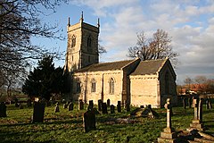 Church of St Andrew, Boothby Graffoe | |
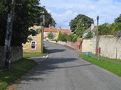 Main Street | |
  Boothby Graffoe Location within Lincolnshire | |
| Population | 223 (2011) |
| OS grid reference | SK985594 |
| • London | 110 mi (180 km) S |
| Unitary authority |
|
| Ceremonial county |
|
| Region |
|
| Country | England |
| Sovereign state | United Kingdom |
| Post town | Lincoln |
| Postcode district | LN5 |
| Police | Lincolnshire |
| Fire | Lincolnshire |
| Ambulance | East Midlands |
| EU Parliament | East Midlands |
| UK Parliament |
|
Boothby Graffoe is a village and civil parish in the North Kesteven district of Lincolnshire, England. The population of the civil parish at the 2011 census was 223.[1] It is situated approximately 7 miles (10 km) south from the city and county town of Lincoln, and on the A607 Ermine Street Roman road.
Boothby Graffoe Grade II listed Anglican parish church is dedicated to St Andrew[2] The church was re-built in 1842. According to the parish registers of Wellingore, Boothby Graffoe's original church was destroyed by a hurricane in 1666.[3]
To the west of the village lies the earthwork remains of Somerton Castle.[4]
References
^ "Civil Parish population 2011". Neighbourhood Statistics. Office for National Statistics. Retrieved 23 April 2016..mw-parser-output cite.citation{font-style:inherit}.mw-parser-output .citation q{quotes:"""""""'""'"}.mw-parser-output .citation .cs1-lock-free a{background:url("//upload.wikimedia.org/wikipedia/commons/thumb/6/65/Lock-green.svg/9px-Lock-green.svg.png")no-repeat;background-position:right .1em center}.mw-parser-output .citation .cs1-lock-limited a,.mw-parser-output .citation .cs1-lock-registration a{background:url("//upload.wikimedia.org/wikipedia/commons/thumb/d/d6/Lock-gray-alt-2.svg/9px-Lock-gray-alt-2.svg.png")no-repeat;background-position:right .1em center}.mw-parser-output .citation .cs1-lock-subscription a{background:url("//upload.wikimedia.org/wikipedia/commons/thumb/a/aa/Lock-red-alt-2.svg/9px-Lock-red-alt-2.svg.png")no-repeat;background-position:right .1em center}.mw-parser-output .cs1-subscription,.mw-parser-output .cs1-registration{color:#555}.mw-parser-output .cs1-subscription span,.mw-parser-output .cs1-registration span{border-bottom:1px dotted;cursor:help}.mw-parser-output .cs1-ws-icon a{background:url("//upload.wikimedia.org/wikipedia/commons/thumb/4/4c/Wikisource-logo.svg/12px-Wikisource-logo.svg.png")no-repeat;background-position:right .1em center}.mw-parser-output code.cs1-code{color:inherit;background:inherit;border:inherit;padding:inherit}.mw-parser-output .cs1-hidden-error{display:none;font-size:100%}.mw-parser-output .cs1-visible-error{font-size:100%}.mw-parser-output .cs1-maint{display:none;color:#33aa33;margin-left:0.3em}.mw-parser-output .cs1-subscription,.mw-parser-output .cs1-registration,.mw-parser-output .cs1-format{font-size:95%}.mw-parser-output .cs1-kern-left,.mw-parser-output .cs1-kern-wl-left{padding-left:0.2em}.mw-parser-output .cs1-kern-right,.mw-parser-output .cs1-kern-wl-right{padding-right:0.2em}
^ Historic England. "St Andrews Church (1061976)". National Heritage List for England. Retrieved 30 June 2011.
^ Cox, J. Charles (1916). Lincolnshire. Methuen & Co. Ltd. p. 67.
^ Historic England. "Somerton Castle (326074)". PastScape. Retrieved 30 June 2011.
See also
"Boothby Graffoe", Genuki.org.uk. Retrieved 30 June 2011- Spring line villages
External links
 Media related to Boothby Graffoe at Wikimedia Commons
 Media related to Boothby Graffoe at Wikimedia Commons


 Ceremonial county of Lincolnshire Ceremonial county of Lincolnshire | |
|---|---|
England Portal | |
| Unitary authorities |
|
| Boroughs or districts |
|
| Major settlements |
|
| Topics |
|
 | This Lincolnshire location article is a stub. You can help Wikipedia by expanding it. |

