Charters Towers Region
Charters Towers Region Queensland | |||||||||||||||
|---|---|---|---|---|---|---|---|---|---|---|---|---|---|---|---|
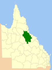 Location within Queensland | |||||||||||||||
| Population | 11,876 (2016)[1] | ||||||||||||||
| • Density | 0.173712080.173712/km2 (0.449912220.449912/sq mi) | ||||||||||||||
| Established | 2008 | ||||||||||||||
| Area | 68,366.0 km2 (26,396.3 sq mi) | ||||||||||||||
| Mayor | Liz Schmidt | ||||||||||||||
| Council seat | Charters Towers | ||||||||||||||
| Region | North Queensland | ||||||||||||||
| State electorate(s) | Traeger | ||||||||||||||
| Federal Division(s) | Kennedy | ||||||||||||||
 | |||||||||||||||
| Website | Charters Towers Region | ||||||||||||||
| |||||||||||||||
The Charters Towers Region is a local government area in North Queensland, Australia southwest of, and inland from the city of Townsville, based in Charters Towers. Established in 2008, it was preceded by two previous local government areas which dated back to the 1870s.
It has an estimated operating budget of A$27.5 m.
Contents
1 History
2 Wards
3 Mayors
4 Towns and localities
5 Libraries
6 Population
7 References
8 External links
History
Prior to 2008, the Charters Towers Region was an entire area of two previous and distinct local government areas:
- the City of Charters Towers;
- and the Shire of Dalrymple.
The City of Charters Towers had its beginning in the Charters Towers Municipality which was proclaimed on 21 June 1877 under the Municipal Institutions Act 1864.[2] It achieved a measure of autonomy in 1878 with the enactment of the Local Government Act. With the passage of the Local Authorities Act 1902, it became the Town of Charters Towers on 31 March 1903 and was proclaimed the City of Charters Towers on 13 April 1909.[3]
The Shire of Dalymple began as Dalrymple Division, one of Queensland's 74 divisions created under the Divisional Boards Act 1879 on 11 November 1879. It became a Shire on 31 March 1903.
In July 2007, the Local Government Reform Commission released its report and recommended that the two areas amalgamate. Amongst its reasons given for this recommendation were improved service delivery and capacity through a larger asset base and increased operating revenue, and the fact that a significant (and growing) proportion of the Shire's population lived in Charters Towers's outer suburbs and bringing all of Charters Towers under one local government was viewed as desirable. It did not consider amalgamation with the neighbouring Townsville/Thuringowa region due to disparate communities of interest. Both councils opposed the amalgamation, although the City Council concluded it was inevitable due to a shared community of interest.[4] On 15 March 2008, the City and Shire formally ceased to exist, and elections were held on the same day to elect councillors and a mayor to the Regional Council.
Wards
The council remains undivided and its elected body consists of six councillors and a mayor.
Mayors
- 2008 - 2012 : Ben Callcott [5]
- 2012 - 2016 : Franklin Beveridge[6]
- 2016 - : Liz Schmidt [7]
Towns and localities

A Rugby league team from Charters towers (1915)
The Charter Towers Region includes the following settlements:
Charters Towers area:
| Dalrymple area:
|
Libraries
Charters Towers Regional Council operate the Excelsior public library in Charters Towers.[8]
Population
The populations given relate to the component entities prior to 2008. The 2011 census was the first for the new Region.
| Year | Population (Region total) | Population (Former City) | Population (Former Shire) |
|---|---|---|---|
| 1933 | 10,238 | 6,978 | 3,260 |
| 1947 | 9,872 | 7,561 | 2,311 |
| 1954 | 8,875 | 6,961 | 1,914 |
| 1961 | 9,839 | 7,633 | 2,206 |
| 1966 | 9,605 | 7,602 | 2,003 |
| 1971 | 9,796 | 7,518 | 2,278 |
| 1976 | 10,494 | 7,914 | 2,580 |
| 1981 | 10,161 | 6,823 | 3,338 |
| 1986 | 11,460 | 7,208 | 4,252 |
| 1991 | 12,500 | 9,016 | 3,484 |
| 1996 | 12,562 | 8,893 | 3,669 |
| 2001 | 12,345 | 8,492 | 3,853 |
| 2006 | 11,937 | 8,155 | 3,782 |
| 2011 | 12,169 | ||
| 2016 | 11,876 |
References
^ Australian Bureau of Statistics (27 June 2017). "Charters Towers (R)". 2016 Census QuickStats. Retrieved 11 December 2017..mw-parser-output cite.citation{font-style:inherit}.mw-parser-output .citation q{quotes:"""""""'""'"}.mw-parser-output .citation .cs1-lock-free a{background:url("//upload.wikimedia.org/wikipedia/commons/thumb/6/65/Lock-green.svg/9px-Lock-green.svg.png")no-repeat;background-position:right .1em center}.mw-parser-output .citation .cs1-lock-limited a,.mw-parser-output .citation .cs1-lock-registration a{background:url("//upload.wikimedia.org/wikipedia/commons/thumb/d/d6/Lock-gray-alt-2.svg/9px-Lock-gray-alt-2.svg.png")no-repeat;background-position:right .1em center}.mw-parser-output .citation .cs1-lock-subscription a{background:url("//upload.wikimedia.org/wikipedia/commons/thumb/a/aa/Lock-red-alt-2.svg/9px-Lock-red-alt-2.svg.png")no-repeat;background-position:right .1em center}.mw-parser-output .cs1-subscription,.mw-parser-output .cs1-registration{color:#555}.mw-parser-output .cs1-subscription span,.mw-parser-output .cs1-registration span{border-bottom:1px dotted;cursor:help}.mw-parser-output .cs1-ws-icon a{background:url("//upload.wikimedia.org/wikipedia/commons/thumb/4/4c/Wikisource-logo.svg/12px-Wikisource-logo.svg.png")no-repeat;background-position:right .1em center}.mw-parser-output code.cs1-code{color:inherit;background:inherit;border:inherit;padding:inherit}.mw-parser-output .cs1-hidden-error{display:none;font-size:100%}.mw-parser-output .cs1-visible-error{font-size:100%}.mw-parser-output .cs1-maint{display:none;color:#33aa33;margin-left:0.3em}.mw-parser-output .cs1-subscription,.mw-parser-output .cs1-registration,.mw-parser-output .cs1-format{font-size:95%}.mw-parser-output .cs1-kern-left,.mw-parser-output .cs1-kern-wl-left{padding-left:0.2em}.mw-parser-output .cs1-kern-right,.mw-parser-output .cs1-kern-wl-right{padding-right:0.2em}

^ 28 Vic No. 21 (Imp)
^ Queensland Government Gazette, Vol. XCII, 13 April 1909, p.1019.
^ Queensland Local Government Reform Commission (July 2007). Report of the Local Government Reform Commission (PDF). 2. pp. 80–84. ISBN 1-921057-11-4. Retrieved 3 June 2010.
^ "2008 Charters Towers Regional Council - Mayoral Election - Election Summary". results.ecq.qld.gov.au. Retrieved 2017-12-04.
^ "2012 Charters Towers Regional Council - Mayoral Election - Election Summary". results.ecq.qld.gov.au. Retrieved 2017-12-04.
^ "2016 Charters Towers Regional Council - Mayoral Election - Election Summary". results.ecq.qld.gov.au. Retrieved 2017-12-04.
^ "Library information". Charters Towers Regional Council. Retrieved 2 February 2018.

External links
- University of Queensland: Queensland Places: Charters Towers Regional Council
Coordinates: 20°06′S 146°16′E / 20.100°S 146.267°E / -20.100; 146.267

