Abiquiu Lake
| Abiquiu Lake | |
|---|---|
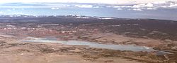 View north from Cerro Pedernal | |
| Location | Rio Arriba County, New Mexico |
| Coordinates | 36°14′24″N 106°25′52″W / 36.240°N 106.431°W / 36.240; -106.431Coordinates: 36°14′24″N 106°25′52″W / 36.240°N 106.431°W / 36.240; -106.431 |
| Type | reservoir |
| Primary inflows | Rio Chama |
| Primary outflows | Rio Chama |
Basin countries | United States |
| Max. length | 12 mi (20 km) |
| Surface area | 5,200 acres (2,100 ha) |
| Water volume | 647,017 acre⋅ft (0.798084 km3) (conservation) 1,192,801 acre⋅ft (1.471298 km3) (flood control) |
Abiquiu Lake is a reservoir located in Rio Arriba County, in northern New Mexico in the southwestern United States. Water of the Rio Chama is impounded by the earth-filled Abiquiu Dam, 1,800 feet (550 m) long and 340 feet (104 m) high, completed in 1963 and raised in 1986. The 5,200-acre (21 km2) lake is over 12 miles (20 km) long, and lies at elevations of 6,100–6,220 feet (1,859–1,896 m).[1]
The shoreline area near the dam is a recreation area managed by the US Army Corps of Engineers (USACE). Available activities include camping, picnicing, hiking, swimming, boating, and fishing.
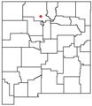
Location in New Mexico

Abiquiu Dam

Abiquiu Lake


References
^
"Abiquiu Lake Morning Report", web:
155-wc Archived May 23, 2014, at the Wayback Machine.. May 22, 2014.
External links
- Corps of Engineers website
- U.S. Geological Survey Geographic Names Information System: Abiquiu Reservoir
This article related to a protected area in New Mexico is a stub. You can help Wikipedia by expanding it. |
This article about a dam or floodgate in the United States is a stub. You can help Wikipedia by expanding it. |


