Randolph County, North Carolina
Randolph County, North Carolina | ||
|---|---|---|
 Randolph County Courthouse and Confederate statue | ||
| ||
 Location in the U.S. state of North Carolina | ||
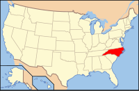 North Carolina's location in the U.S. | ||
| Founded | 1779 | |
| Named for | Peyton Randolph | |
| Seat | Asheboro | |
| Largest city | Asheboro | |
| Area | ||
| • Total | 789 sq mi (2,044 km2) | |
| • Land | 783 sq mi (2,028 km2) | |
| • Water | 6.8 sq mi (18 km2), 0.9% | |
| Population | ||
| • (2010) | 141,752 | |
| • Density | 181/sq mi (70/km2) | |
| Congressional district | 6th | |
| Time zone | Eastern: UTC−5/−4 | |
| Website | www.randolphcountync.gov | |


The new Randolph County Courthouse opened in 2002
Randolph County is a county located in the U.S. state of North Carolina. As of the 2010 census, the population was 141,752.[1] Its county seat is Asheboro.[2]
Randolph County is included in the Greensboro-High Point, NC Metropolitan Statistical Area, which is also included in the Greensboro-Winston-Salem-High Point, NC Combined Statistical Area.
In 2010, the center of population of North Carolina was located in Randolph County, near the town of Seagrove.[3]
Contents
1 History
1.1 County formation
2 Geography
2.1 Adjacent counties
2.2 Major highways
3 Demographics
4 Communities
4.1 Cities
4.2 Towns
4.3 Townships
4.4 Unincorporated communities
5 Politics, law and government
6 Education
7 Notable people
8 See also
9 References
10 External links
History
Some of the first settlers of what would become the county were English Quakers, who settled along the Haw, Deep, and Eno Rivers.[4] The county was formed in 1779 from Guilford County. It was named for Peyton Randolph, first president of the Continental Congress.
County formation
The Legislature of 1779, then sitting at Halifax, passed an act providing for the formation of a new county out of Guilford and Rowan, to be called Randolph. Notice having been given, the citizens met accordingly on Monday, the 8th day of March, 1779. Proclamation being made, the act of Assembly was read, wherein, William Cole, John Collin, Joseph Hinds, George Cortner, John Arnold, William Millikan, John Hinds, Jacob Shepherd, Richardson Owen, Windsor Pearce, William Bell, William Merrill, John Lowe, Enoch Davis, and James Hunter were nominated Justices for holding the courts in said county. The oath of allegiance and the oath of office was administered by William Cole, Esq., whereupon they took their seats and organized and held the first court in Randolph county by electing William Bell, Sheriff, William Millikan, Register of Deeds, and Absalom Tatum', Clerk.[5]
Randolph County was the original location of what became Duke University.
The county is home to one of the last remaining covered bridges in the state. The Pisgah Covered Bridge, in Union Township, in the southwestern part of the county, was destroyed by a flood in 2003, but has been completely restored and is still standing.[6][7]
In 1911, a new county called Piedmont County was proposed, with High Point as its county seat, to be created from Guilford, Davidson, and Randolph Counties. Many people appeared at the Guilford County courthouse to oppose the plan, vowing to go to the state legislature to protest. The state legislature voted down the plan in February 1911.[8][9]
Geography
According to the U.S. Census Bureau, the county has a total area of 789 square miles (2,040 km2), of which 783 square miles (2,030 km2) is land and 6.8 square miles (18 km2) (0.9%) is covered by water.[10]
Randolph County is located in the center of North Carolina, and the city of Asheboro (in the county) is the center point of North Carolina. Randolph County is located in the Piedmont section of central North Carolina, a region of gently rolling hills and woodlands. However, the central and western parts of the county contain the Uwharrie Mountains and the Caraway Mountains. These two ranges are the remnants of a much-higher range of ancient peaks. Today, they rarely top 1,000 feet (300 m) above sea level, yet due to the relative low terrain around them, they still rise 200–500 feet (61–152 m) above their base. The highest point in Randolph County is Shepherd Mountain, a peak in the Caraways. The North Carolina Zoo is located atop Purgatory Mountain, one of the peaks of the Uwharries.
Adjacent counties
Guilford County - north
Alamance County - northeast
Chatham County - east
Moore County - southeast
Montgomery County - southwest
Davidson County - west
Major highways
 I-73
I-73
 I-74
I-74
 I-85
I-85
 I-85 Bus.
 US 29
US 29
 US 64
US 64
 US 70
US 70
 US 220
 US 311
 US 421
 NC 22
NC 22
 NC 42
NC 42
 NC 47
NC 47
 NC 49
NC 49
 NC 62
NC 62
 NC 109
 NC 134
 NC 159
 NC 705
Demographics
| Historical population | |||
|---|---|---|---|
| Census | Pop. | %± | |
| 1790 | 7,318 | — | |
| 1800 | 9,234 | 26.2% | |
| 1810 | 10,112 | 9.5% | |
| 1820 | 11,331 | 12.1% | |
| 1830 | 12,406 | 9.5% | |
| 1840 | 12,875 | 3.8% | |
| 1850 | 15,832 | 23.0% | |
| 1860 | 16,793 | 6.1% | |
| 1870 | 17,551 | 4.5% | |
| 1880 | 20,836 | 18.7% | |
| 1890 | 25,195 | 20.9% | |
| 1900 | 28,232 | 12.1% | |
| 1910 | 29,491 | 4.5% | |
| 1920 | 30,856 | 4.6% | |
| 1930 | 36,259 | 17.5% | |
| 1940 | 44,554 | 22.9% | |
| 1950 | 50,804 | 14.0% | |
| 1960 | 61,497 | 21.0% | |
| 1970 | 76,358 | 24.2% | |
| 1980 | 91,728 | 20.1% | |
| 1990 | 106,546 | 16.2% | |
| 2000 | 130,454 | 22.4% | |
| 2010 | 141,752 | 8.7% | |
| Est. 2016 | 143,416 | [11] | 1.2% |
| U.S. Decennial Census[12] 1790-1960[13] 1900-1990[14] 1990-2000[15] 2010-2013[1] | |||
As of the census[16] of 2000, 130,454 people, 50,659 households, and 37,335 families resided in the county. The population density was 166 people per square mile (64/km²). The 54,422 housing units averaged 69 per square mile (27/km²). The racial makeup of the county was 89.20% White, 5.63% Black or African American, 0.45% Native American, 0.64% Asian, 0.02% Pacific Islander, 3.01% from other races, and 1.06% from two or more races. About 6.63% of the population was Hispanic or Latino of any race.
As with much of North Carolina, the Latino population of Randolph County continued to grow into the 21st century. In 2005, figures placed the Latino population as 9.3% of the county’s total.
In 2000, of the 50,659 households, 33.70% had children under the age of 18 living with them, 59.10% were married couples living together, 10.20% had a female householder with no husband present, and 26.30% were not families. About 22.50% of all households were made up of individuals, and 8.60% had someone living alone who was 65 years of age or older. The average household size was 2.55 and the average family size was 2.97.
In the county, the population was distributed as 25.00% under the age of 18, 8.00% from 18 to 24, 31.30% from 25 to 44, 23.50% from 45 to 64, and 12.10% who were 65 years of age or older. The median age was 36 years. For every 100 females, there were 97.80 males. For every 100 females age 18 and over, there were 95.40 males.
The median income for a household in the county was $38,348, and for a family was $44,369. Males had a median income of $30,575 versus $22,503 for females. The per capita income for the county was $18,236. About 6.80% of families and 9.10% of the population were below the poverty line, including 11.60% of those under age 18 and 11.50% of those age 65 or over.
Communities
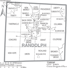
Map of Randolph County, North Carolina With Municipal and Township Labels
Cities
Archdale (part)
Asheboro (county seat)
High Point (part)- Randleman
Thomasville (part)- Trinity
Towns
- Franklinville
- Liberty
- Ramseur
- Seagrove
- Staley
Townships
- Asheboro
- Archdale
- Back Creek
- Brower
- Cedar Grove
- Coleridge
- Columbia
- Concord
- Farmer
- Franklinville
- Grant
- Level Cross
- Liberty
- New Hope
- New Market
- Pleasant Grove
- Providence
- Randleman
- Richland
- Tabernacle
- Trinity
- Union
Unincorporated communities
- Cedar Grove
- Climax
- Coleridge
- Erect
- Farmer
- Level Cross
- Pisgah
- Sophia
- Ulah
- Whynot
Politics, law and government
Randolph County is a member of the regional Piedmont Triad Council of Governments. The county is predominantly Republican; it is often considered one of the most Republican-dominated counties in the state, with most local elections having only a Republican on the ballot. No Democratic Presidential nominee has carried Randolph County since Franklin D. Roosevelt in 1940; in 1964 it was the easternmost county in the state to vote for Barry Goldwater.
| Year | Republican | Democratic | Third parties |
|---|---|---|---|
2016 | 76.6% 49,430 | 20.4% 13,194 | 3.0% 1,951 |
2012 | 74.4% 45,160 | 24.3% 14,773 | 1.3% 782 |
2008 | 70.5% 40,998 | 28.2% 16,414 | 1.3% 735 |
2004 | 74.2% 37,771 | 25.5% 12,966 | 0.3% 173 |
2000 | 72.5% 30,959 | 26.6% 11,366 | 0.9% 371 |
1996 | 61.4% 23,030 | 28.7% 10,783 | 9.9% 3,722 |
1992 | 53.2% 20,697 | 29.0% 11,274 | 17.8% 6,931 |
1988 | 73.3% 23,881 | 26.5% 8,641 | 0.2% 49 |
1984 | 77.4% 25,759 | 22.6% 7,511 | 0.1% 29 |
1980 | 64.7% 19,881 | 32.9% 10,107 | 2.4% 729 |
1976 | 52.7% 14,337 | 46.8% 12,714 | 0.5% 146 |
1972 | 76.0% 18,724 | 21.7% 5,346 | 2.3% 559 |
1968 | 52.4% 13,450 | 20.8% 5,351 | 26.8% 6,892 |
1964 | 56.4% 13,739 | 43.6% 10,638 | |
1960 | 61.7% 15,772 | 38.3% 9,789 | |
1956 | 61.1% 13,174 | 39.0% 8,404 | |
1952 | 58.1% 12,429 | 41.9% 8,975 | |
1948 | 53.4% 8,372 | 41.9% 6,567 | 4.7% 743 |
1944 | 54.7% 8,768 | 45.4% 7,277 | |
1940 | 45.5% 7,056 | 54.5% 8,455 | |
1936 | 46.1% 6,927 | 53.9% 8,090 | |
1932 | 45.0% 6,072 | 54.4% 7,345 | 0.6% 75 |
1928 | 63.9% 7,414 | 36.1% 4,188 | |
1924 | 53.9% 6,336 | 45.9% 5,397 | 0.2% 24 |
1920 | 55.2% 6,297 | 44.8% 5,110 | |
1916 | 52.4% 3,031 | 47.5% 2,747 | 0.1% 3 |
1912 | 7.6% 370 | 55.0% 2,665 | 37.4% 1,815 |
Education
Randolph County School System serves most of the county. Asheboro City Schools serves Asheboro.
Fayetteville Street Christian School, located in Asheboro, is the largest private school in Randolph County.[18]
Notable people
Sam Ard - NASCAR driver
Jerry Bledsoe - author
Braxton Craven - educator and second president of Trinity College, which later moved to Durham and became Duke University
Rufus Hussey - The Beanshooter Man who appeared on The Tonight Show Starring Johnny Carson.[19]
Adam Petty - NASCAR driver. Son of Kyle Petty. Killed in New Hampshire.
Kyle Petty - NASCAR driver. Son of Richard Petty
Lee Petty - NASCAR pioneer. Father of Richard Petty.
Richard Petty - NASCAR driver. Son of Lee Petty.
Naomi Wise - murder victim
Jonathan Worth - North Carolina Governor
See also
- National Register of Historic Places listings in Randolph County, North Carolina
References
^ ab "State & County QuickFacts". United States Census Bureau. Retrieved October 29, 2013..mw-parser-output cite.citation{font-style:inherit}.mw-parser-output q{quotes:"""""""'""'"}.mw-parser-output code.cs1-code{color:inherit;background:inherit;border:inherit;padding:inherit}.mw-parser-output .cs1-lock-free a{background:url("//upload.wikimedia.org/wikipedia/commons/thumb/6/65/Lock-green.svg/9px-Lock-green.svg.png")no-repeat;background-position:right .1em center}.mw-parser-output .cs1-lock-limited a,.mw-parser-output .cs1-lock-registration a{background:url("//upload.wikimedia.org/wikipedia/commons/thumb/d/d6/Lock-gray-alt-2.svg/9px-Lock-gray-alt-2.svg.png")no-repeat;background-position:right .1em center}.mw-parser-output .cs1-lock-subscription a{background:url("//upload.wikimedia.org/wikipedia/commons/thumb/a/aa/Lock-red-alt-2.svg/9px-Lock-red-alt-2.svg.png")no-repeat;background-position:right .1em center}.mw-parser-output .cs1-subscription,.mw-parser-output .cs1-registration{color:#555}.mw-parser-output .cs1-subscription span,.mw-parser-output .cs1-registration span{border-bottom:1px dotted;cursor:help}.mw-parser-output .cs1-hidden-error{display:none;font-size:100%}.mw-parser-output .cs1-visible-error{font-size:100%}.mw-parser-output .cs1-subscription,.mw-parser-output .cs1-registration,.mw-parser-output .cs1-format{font-size:95%}.mw-parser-output .cs1-kern-left,.mw-parser-output .cs1-kern-wl-left{padding-left:0.2em}.mw-parser-output .cs1-kern-right,.mw-parser-output .cs1-kern-wl-right{padding-right:0.2em}
^ "Find a County". National Association of Counties. Retrieved 2011-06-07.
^ "Centers of Population by State: 2010". United States Census Bureau. Retrieved April 13, 2014.
^ Bishir, Catherine (2005). North Carolina Architecture. UNC Press. p. 38.
^ Reminiscences of Randolph County, author: J.A.Blair 1890
^ Mark Brumley and Cynthia Jeffries, "Rain Washes Away Historical Bridge," Greensboro News & Record, August 11, 2003.
^ "You don't have to go far for local history," Greensboro News & Record, June 19, 2010.
^ Jack Scism, "Remember When?", Greensboro News & Record, January 23, 2011.
^ Jack Scism, "Remember When?", Greensboro News & Record, February 6, 2011.
^ "2010 Census Gazetteer Files". United States Census Bureau. August 22, 2012. Archived from the original on January 12, 2015. Retrieved January 19, 2015.
^ "Population and Housing Unit Estimates". Retrieved June 9, 2017.
^ "U.S. Decennial Census". United States Census Bureau. Retrieved January 19, 2015.
^ "Historical Census Browser". University of Virginia Library. Retrieved January 19, 2015.
^ Forstall, Richard L., ed. (March 27, 1995). "Population of Counties by Decennial Census: 1900 to 1990". United States Census Bureau. Retrieved January 19, 2015.
^ "Census 2000 PHC-T-4. Ranking Tables for Counties: 1990 and 2000" (PDF). United States Census Bureau. April 2, 2001. Retrieved January 19, 2015.
^ "American FactFinder". United States Census Bureau. Retrieved 2008-01-31.
^ Leip, David. "Dave Leip's Atlas of U.S. Presidential Elections". uselectionatlas.org.
^ "Fayetteville Street Christian School". www.fscspatriots.org. Retrieved 2018-03-17.
^ "Rufus Hussey... The Beanshooter Man". www.asheboro.com.
External links
| Wikimedia Commons has media related to Randolph County, North Carolina. |
- Official website
NCGenWeb Randolph County - free genealogy resources for the county- Official Visitor Information
- North Carolina Architects & Builders
Places adjacent to Randolph County, North Carolina | ||||||||||
|---|---|---|---|---|---|---|---|---|---|---|
| ||||||||||
Municipalities and communities of Randolph County, North Carolina, United States | ||
|---|---|---|
County seat: Asheboro | ||
| Cities |
|  |
| Towns |
| |
| Unincorporated communities |
| |
| Footnotes | ‡This populated place also has portions in an adjacent county or counties | |
Raleigh (capital) | ||
| Topics |
|  Seal of North Carolina |
| Society |
| |
| Regions |
| |
| Largest cities |
| |
| Smaller cities |
| |
| Major towns |
| |
| Counties |
| |
Coordinates: 35°43′N 79°49′W / 35.71°N 79.81°W / 35.71; -79.81


