Bow Road tube station
Bow Road  | |
|---|---|
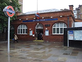 | |
  Bow Road Location of Bow Road in Greater London | |
| Location | Bow |
| Local authority | London Borough of Tower Hamlets |
| Managed by | London Underground |
| Owner | Transport for London |
| Number of platforms | 2 |
| Fare zone | 2 |
| OSI | Bow Church  [1] [1] |
| London Underground annual entry and exit | |
| 2013 |  5.60 million[2] 5.60 million[2] |
| 2014 | 5.77 million[2] |
| 2015 | 6.10 million[2] |
| 2016 |  5.65 million[2] 5.65 million[2] |
| 2017 | 5.66 million[2] |
| Railway companies | |
| Original company | Whitechapel and Bow Railway |
| Key dates | |
| 1902 | Opened |
| 1950 | Ownership transferred to London Transport |
Listed status | |
| Listing grade | II |
| Entry number | 1357787[3] |
| Added to list | 27 September 1973 |
| Other information | |
| Lists of stations |
|
| External links |
|
| WGS84 | 51°31′38″N 0°01′29″W / 51.52722°N 0.02472°W / 51.52722; -0.02472Coordinates: 51°31′38″N 0°01′29″W / 51.52722°N 0.02472°W / 51.52722; -0.02472 |
 London transport portal London transport portal | |
Bow Road is a London Underground station in Bow, East End of London, England. It is on the District and Hammersmith & City lines. The station is interlinked as an out of station interchange (OSI) with Bow Church station on the Docklands Light Railway which is about 300 m (980 ft) away via Bow Road. The two Bow stations are classed as a single station for ticketing purposes as well as on tube maps but both managed separately.
Contents
1 History
2 Design
3 Bow Church DLR station
4 Connections
5 References
6 External links
History
The station was opened in 1902 by the Whitechapel and Bow Railway (which was later incorporated into the District line), with the Hammersmith & City line (then the Metropolitan line) following in 1936.
The Great Eastern Railway Bow Road railway station, which closed in 1949, stood on the opposite of Bow Road.
Ownership of the station passed to London Underground in 1950.[4]
Design
The station booking hall is a Grade II listed building.
Bow Road marks the point where westbound trains from Upminster and Barking enter a tunnel; the gradient of the tunnel approach, which is to the east of the station, is 1 in 28, the steepest on the tube network.[5] The station platforms are below street level, partly in a tunnel (the western end of the platforms) and partly in an open cutting (the eastern end).

View eastward at platform level in 1961
Bow Church DLR station

Sign to Bow Church DLR.
Bow Road is connected east via thoroughfare of the same name to Bow Church station on the Docklands Light Railway (DLR) between Stratford and Canary Wharf as an out of station interchange (OSI) classed as a single station for ticketing purposes but are managed as separate stations.[6]
Connections
London Buses services serve the station, key routes 25 and 205, local route 425, and night route N205.
References
^ "Out-of-Station Interchanges" (Microsoft Excel). Transport for London. 2 January 2016. Retrieved 28 August 2016..mw-parser-output cite.citation{font-style:inherit}.mw-parser-output .citation q{quotes:"""""""'""'"}.mw-parser-output .citation .cs1-lock-free a{background:url("//upload.wikimedia.org/wikipedia/commons/thumb/6/65/Lock-green.svg/9px-Lock-green.svg.png")no-repeat;background-position:right .1em center}.mw-parser-output .citation .cs1-lock-limited a,.mw-parser-output .citation .cs1-lock-registration a{background:url("//upload.wikimedia.org/wikipedia/commons/thumb/d/d6/Lock-gray-alt-2.svg/9px-Lock-gray-alt-2.svg.png")no-repeat;background-position:right .1em center}.mw-parser-output .citation .cs1-lock-subscription a{background:url("//upload.wikimedia.org/wikipedia/commons/thumb/a/aa/Lock-red-alt-2.svg/9px-Lock-red-alt-2.svg.png")no-repeat;background-position:right .1em center}.mw-parser-output .cs1-subscription,.mw-parser-output .cs1-registration{color:#555}.mw-parser-output .cs1-subscription span,.mw-parser-output .cs1-registration span{border-bottom:1px dotted;cursor:help}.mw-parser-output .cs1-ws-icon a{background:url("//upload.wikimedia.org/wikipedia/commons/thumb/4/4c/Wikisource-logo.svg/12px-Wikisource-logo.svg.png")no-repeat;background-position:right .1em center}.mw-parser-output code.cs1-code{color:inherit;background:inherit;border:inherit;padding:inherit}.mw-parser-output .cs1-hidden-error{display:none;font-size:100%}.mw-parser-output .cs1-visible-error{font-size:100%}.mw-parser-output .cs1-maint{display:none;color:#33aa33;margin-left:0.3em}.mw-parser-output .cs1-subscription,.mw-parser-output .cs1-registration,.mw-parser-output .cs1-format{font-size:95%}.mw-parser-output .cs1-kern-left,.mw-parser-output .cs1-kern-wl-left{padding-left:0.2em}.mw-parser-output .cs1-kern-right,.mw-parser-output .cs1-kern-wl-right{padding-right:0.2em}
^ abcde "Multi-year station entry-and-exit figures" (XLSX). London Underground station passenger usage data. Transport for London. January 2018. Retrieved 22 July 2018.
^ Historic England. "Details from listed building database (1357787)". National Heritage List for England. Retrieved 12 November 2012.
^ "Transport Act, 1947" (PDF). The London Gazette. 27 January 1950. p. 480. Retrieved 28 November 2012.
^ "London Underground Statistics". trainweb.org. Retrieved 25 September 2012.
^ "Out-of-Station Interchanges" (Microsoft Excel). Transport for London. 2 January 2016. Retrieved 28 August 2016.
External links
 | Wikimedia Commons has media related to Bow Road tube station. |
| Preceding station | |  London Underground London Underground | | Following station |
|---|---|---|---|---|
Mile End towards Hammersmith | Hammersmith & City line | Bromley-by-Bow towards Barking | ||
Mile End towards Wimbledon, Richmond or Ealing Broadway | District line | Bromley-by-Bow towards Upminster | ||
| | Former services | | ||
Mile End towards Hammersmith | Metropolitan line Hammersmith branch (1936-1990) | Bromley-by-Bow towards Barking | ||
District line | |||||||||||
|---|---|---|---|---|---|---|---|---|---|---|---|
| Stations |
| ||||||||||
| Rolling stock |
| ||||||||||
| History |
| ||||||||||
| Depots |
| ||||||||||
| See also |
| ||||||||||
| |||||||||||


Hammersmith & City line | |||||
|---|---|---|---|---|---|
| Stations |
| ||||
| Rolling stock |
| ||||
| History |
| ||||
| See also |
| ||||
| |||||
Metropolitan line | |||||||||||||||||
|---|---|---|---|---|---|---|---|---|---|---|---|---|---|---|---|---|---|
| Stations |
| ||||||||||||||||
| Rolling stock |
| ||||||||||||||||
| History |
| ||||||||||||||||
| Future proposals |
| ||||||||||||||||
| |||||||||||||||||

