Eldorado Valley
| Eldorado Valley | |
|---|---|
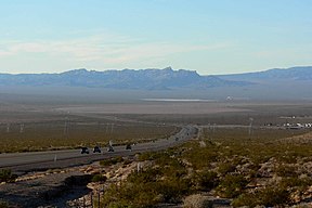 View south of Eldorado Valley's center & north; (Highland Range, (center photo) on valley's southwest perimeter; playa visible, ~5-mi) | |
 Eldorado Valley Eldorado Valley (north at Eldorado Dry Lake) in Nevada | |
| Length | 35 mi (56 km) |
| Width | 18 mi (29 km) |
| Geography | |
| Location | Nevada, United States (southeast)-Mojave Desert (central-southeast)-Great Basin |
| Population centers | Boulder City, NV-NE Searchlight, NV-(south) Henderson, NV-NW |
| Borders on | McCullough Range-W River Mountains-NNE Eldorado Mountains-E Piute Valley-S Highland Range-SSW |
| Coordinates | 35°52.211′N 114°55.975′W / 35.870183°N 114.932917°W / 35.870183; -114.932917Coordinates: 35°52.211′N 114°55.975′W / 35.870183°N 114.932917°W / 35.870183; -114.932917 |
Eldorado Valley, or El Dorado Valley, is a Great Basin valley in the Mojave Desert southeast of Las Vegas and southwest of Boulder City, Nevada. The valley is endorheic, containing the Eldorado Dry Lake. The Great Basin Divide, transects ridgelines and saddles, on the north, northeast, east, and south around the valley, as the valley sits on the east of the McCullough Range, a Great Basin massif, on the Great Basin Divide at its north terminus and its south terminus.
Contents
1 Geography
2 Solar power
3 Highland Range Crucial Bighorn Habitat
4 References
5 External links
Geography
The north end of the valley contains a large salt pan, or dry lake, Dry Lake or Eldorado Playa, while the southern two thirds drains northwards.[1]U.S. Route 95 traverses eastern portions of the valley, and climbs steeply to meet U.S. Route 93, connecting Boulder City to Henderson.
The endorheic basin lies north of the Piute Wash Watershed,[2] of the north-south Piute Valley. The Piute Wash drains south, then southeast to the Colorado River.
Solar power
The valley contains Boulder City’s "Eldorado Energy Zone" which is home to the 480 MW El Dorado natural gas power plant completed in the year 2000.[3]
Since 2007, it is also home to the concentrated solar power plant, Nevada Solar One, as well as a growing number of photovoltaic power stations, including:[4][5][6]
- Copper Mountain Solar Facility
- Boulder Solar Project
- Techren Solar Project
Highland Range Crucial Bighorn Habitat
A habitat nature reserve for the Desert Bighorn Sheep is located in the southern portion of the Eldorado Valley, named the 'Highland Range Crucial Bighorn Habitat'.[7] There are no public access routes into the habitat area, to protect the Bighorn.

Valley's center-south, from east side.
(North end of Highland Range (from east-southeast), McCullough Range massif beyond.)

References
| Wikimedia Commons has media related to Eldorado Valley. |
^ U.S. Geological Survey Geographic Names Information System: Dry Lake
^ "Piute Wash watershed--15030102". U.S. Environmental Protection Agency. Retrieved 13 August 2011..mw-parser-output cite.citation{font-style:inherit}.mw-parser-output .citation q{quotes:"""""""'""'"}.mw-parser-output .citation .cs1-lock-free a{background:url("//upload.wikimedia.org/wikipedia/commons/thumb/6/65/Lock-green.svg/9px-Lock-green.svg.png")no-repeat;background-position:right .1em center}.mw-parser-output .citation .cs1-lock-limited a,.mw-parser-output .citation .cs1-lock-registration a{background:url("//upload.wikimedia.org/wikipedia/commons/thumb/d/d6/Lock-gray-alt-2.svg/9px-Lock-gray-alt-2.svg.png")no-repeat;background-position:right .1em center}.mw-parser-output .citation .cs1-lock-subscription a{background:url("//upload.wikimedia.org/wikipedia/commons/thumb/a/aa/Lock-red-alt-2.svg/9px-Lock-red-alt-2.svg.png")no-repeat;background-position:right .1em center}.mw-parser-output .cs1-subscription,.mw-parser-output .cs1-registration{color:#555}.mw-parser-output .cs1-subscription span,.mw-parser-output .cs1-registration span{border-bottom:1px dotted;cursor:help}.mw-parser-output .cs1-ws-icon a{background:url("//upload.wikimedia.org/wikipedia/commons/thumb/4/4c/Wikisource-logo.svg/12px-Wikisource-logo.svg.png")no-repeat;background-position:right .1em center}.mw-parser-output code.cs1-code{color:inherit;background:inherit;border:inherit;padding:inherit}.mw-parser-output .cs1-hidden-error{display:none;font-size:100%}.mw-parser-output .cs1-visible-error{font-size:100%}.mw-parser-output .cs1-maint{display:none;color:#33aa33;margin-left:0.3em}.mw-parser-output .cs1-subscription,.mw-parser-output .cs1-registration,.mw-parser-output .cs1-format{font-size:95%}.mw-parser-output .cs1-kern-left,.mw-parser-output .cs1-kern-wl-left{padding-left:0.2em}.mw-parser-output .cs1-kern-right,.mw-parser-output .cs1-kern-wl-right{padding-right:0.2em}
^ "El Dorado Energy begins commercial operations in Nevada". gasandoil.com. 4 May 2000. Retrieved 11 February 2019.
^ "Boulder City OKs deal for solar power plant". lasvegassun.com. 22 February 2011. Retrieved 11 February 2019.
^ "NV Energy's Boulder Solar 2 goes fully online". lasvegasnow.com. 13 February 2017. Retrieved 11 February 2019.
^ "Solar projects". NVEnergy. Retrieved 13 August 2011.
^ "Highland Range Crucial Bighorn Habitat". recreation.gov. Retrieved 13 August 2011.
External links
Las Vegas Wash Watershed; Havasu-Mohave Lakes Watershed
- Eldorado Playa, Geomicrobiological Changes (coord)
- Eldorado Dry Lake, Eldorado Valley Flyers.com-(elevation 1750ft)
- (Eldorado Dry Lake), RiderPlanet-USA, riderplanet-usa.com (elevation) & Photo gallery
This Nevada state location article is a stub. You can help Wikipedia by expanding it. |


