Ivano-Frankivsk Oblast
Ivano-Frankivsk Oblast Івано-Франківська область Ivano-Frankivs’ka oblast’ | |||
|---|---|---|---|
Oblast | |||
| |||
| Nickname(s): Івано-Франківщина (Ivano-Frankivshchyna); Prykarpattia | |||
 | |||
| Country | |||
| Established | December 4, 1939 (as "Stanislav Oblast") | ||
| Administrative center | Ivano-Frankivsk | ||
| Largest cities | Ivano-Frankivsk, Kalush, Kolomyia | ||
| Government | |||
| • Governor | Oleh Honcharuk[1] (Batkivshchyna[1]) | ||
| • Oblast council | 114 (120) seats | ||
| • Chairperson | Vasyl' Skrypnychuk (Svoboda) | ||
| Area | |||
| • Total | 13,900 km2 (5,400 sq mi) | ||
| Area rank | Ranked 22nd | ||
| Population (October 2008[2]) | |||
| • Total | 1,381,700 | ||
| • Rank | Ranked 13th | ||
| • Density | 99/km2 (260/sq mi) | ||
| Demographics | |||
| • Official language(s) | Ukrainian | ||
| • Average salary | UAH 889 (2006) | ||
| Time zone | UTC+2 (EET) | ||
| • Summer (DST) | UTC+3 (EEST) | ||
| Postal code | 88-90xxx | ||
| Area code | +380-34 | ||
| ISO 3166 code | UA-26 | ||
| Vehicle registration | AT | ||
| Raions | 14 | ||
Cities (total) | 15 | ||
| • Regional cities | 6 | ||
| Urban-type settlements | 24 | ||
| Villages | 477[3][4] | ||
| FIPS 10-4 | UP06 | ||
| Website | www.if.gov.ua www.rada.gov.ua | ||


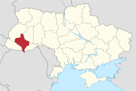
Ivano-Frankivsk Oblast (Ukrainian: Івано-Франківська область, translit. Ivano-Frankivs’ka oblast’; also referred to as Prykarpattia – Ukrainian: Прикарпаття or formerly as Stanislavshchyna or Stanislavivshchyna – Ukrainian: Станіславщина or Станиславівщина) is an oblast (region) in western Ukraine. Its administrative center is the city of Ivano-Frankivsk. As is the case with most other oblasts of Ukraine this region has the same name as its administrative center – which was renamed by the Soviet Ukrainian authorities after the Ukrainian writer Ivan Franko on November 9, 1962. Population: 1,382,352 (2016 est.)[5].
Ivano-Frankivsk Oblast is also known to Ukrainians by a deep-rooted alternative name: Prykarpattia (although some sources may also consider the southern Lviv Oblast including such cities as Stryi, Truskavets, and Drohobych, as also part of Prykarpattia).[citation needed] Prykarpattia, together with Lviv and Ternopil regions, was the main body of the historic region of eastern Halychyna; which in the 13th century was a part of the Kingdom of Rus and the Halych-Volyn Principality (see Kingdom of Galicia–Volhynia). Along with the Lviv and Ternopil regions Prykarpattia is a component of the Carpathian Euroregion.
During the times of the Second Polish Republic the area was known as Stanisławów Voivodeship (1918–1939) and later, after the Soviet invasion of Poland, as Stanislav Oblast (1939–1962). During the World War II it was part of the District of Galicia in General Governorate. Until the 20th century the major center of the region was the city of Kolomyia (which is a major cultural center of Pokuttya, the traditional name for the southern part of the oblast).
Contents
1 Name
2 Geography
2.1 Relief
2.2 Hydrology
2.3 Nature Sanctuaries
3 Government
4 Regional Subdivisions
4.1 Primary divisions
4.2 Secondary divisions
4.3 Historical overview of subdivisions
5 Demographics
5.1 Religion
5.2 Age structure
5.3 Median age
6 Culture and Tourism
7 Historical and Cultural Sites
7.1 Popular culture
8 Transportation
8.1 Roads
9 Notable people
10 See also
11 References
12 External links
Name
As with the rest of Ukraine's oblasts Ivano-Frankivsk may also be known by its matronymical name Ivano-Frankivshchyna. However, that name did not receive general public acceptance and commonly Ivano-Frankivsk Oblast is almost always called Prykarpattya – a historic name for the same region. (Geographically the historic region covers a much larger portion of Ukraine than just the Ivano-Frankivsk region.)
Geography
Ivano-Frankivsk Oblast borders Lviv Oblast to its north and west, Zakarpattya Oblast to its south-west, has a 50-km long state border with Romania (Maramureş County) to its immediate south, and it borders Chernivtsi Oblast to the south-east and Ternopil Oblast to the east. It is situated partly in the Eastern European Plain and partly Carpathian Foothills. The oblast may be divided into three regions: mountainous, pre-mountainous, and plains.
The climate is mildly-continental and damp with cool summers and mild winters. The average monthly temperature in June is 18 °C (64 °F) with 12 to 16 °C (54 to 61 °F) in the mountains. The average monthly temperature in January is −4 °C (25 °F) with −6 °C (21 °F) in the mountains. Average precipitation varies annually around 650 mm (25.6 in) with 1,550 mm (61 in) in the mountains.
Relief

Geology of Ukraine
The region is situated between two main regional tectonic plates: Carpathian fold belt and Volhynia-Podillya plate. The most prominent features of the first one are the Carpathian Mountains, while the second one - Dniester river.
The Carpathian Mountains contribute tremendously to the change in relief of Ivano-Frankivsk Oblast and their elevation rises from north-east to south-west stretching along the oblast's south-western border. The elevation of the oblast varies from 230m to 2,061m above sea level. The mountains occupy almost one half of the whole Oblast and consist of two main mountain ranges: the Gorgany (highest peak – Mt. Syvulya Major (1,836m)) and the Chornohora range (highest peak – Mt. Hoverla (2,061m)).
The rest of Ivano-Frankivsk Oblast is located within the Dniester river and Prut river valleys. The plains of the oblast are part of the Carpathian Foothills and Opillia Upland (part of Podillia Upland) which are cut through by Dniester. The upland has a temperate-climate habitat mixed with grassland and woodland – also known as the forest steppe. The relief of the region consists mostly of rolling hills of 230-400m over the sea level. Near river valleys are common canyons and ravines.
The Dniester flows mainly through the Halych Raion and along the administrative border between Ivano-Frankivsk and Ternopil Oblasts. The territory of the region within immediate proximity to the river is traditionally known as Opillia. Opillia, however, stretches far beyond the oblast and only covers two of its raions: Halych Raion and Rohatyn Raion, both located in the north. Relief in the area consists of rolling hills uplands.
The Carpathian foothills consist mostly of low denudation accumulative uplands, while the right bank of Dniester along the border with the Ternopil Oblast depicts karst type relief of Pokuttia Upland. Because of it near that area along Dniester relief shows forms of canyon. Pokuttia Upland between Bystrytsia of Nadvirna and Prut River (Prut-Bystrytsia Upland) serves as drainage divide within the oblast between Dniester and Prut. Carpathian foothills have two depressions: one is at the confluence of Bystrytsia of Solotvyn, Bystrytsia of Nadvirna, Vorona and Bystrytsia rivers, called Bystrytsia Depression, and another is around the city of Kalush, called Kalush Depression.
Hydrology
Oblast has plethora of rivers, waterfalls, mountainous brooks, and smaller ponds, but there is almost no other type of bodies of water such as lakes and water reservoirs. Most of rivers either flow into Dniester or Prut River (tributary of Danube). The total water drainage area of the region is 13,900 km2 (5,400 sq mi). Segments of Dniester and Cheremosh River are used as administrative borders with Ternopil and Chernivtsi oblasts respectfully.
The water drainage divide between Dniester and Prut cuts the region through middle of following districts: Nadvirna Raion, Kolomyia Raion, Tlumach Raion, and Horodenka Raion.
Nature Sanctuaries
The region is a home to some 456 preserved areas (on June 1, 2006) of some 195,633 ha (483,420 acres), 30 out of which are of all-national importance with an area of 108,742 ha (268,710 acres) and the rest of a local importance.[6] In the Ivano-Frankivsk Region is located a strict nature reserve Gorgany that was created in 1996. There are five national parks in the region. There are numerous natural monuments of feature and habitat management areas (zakazniks).
| Park | District |
|---|---|
Carpathian National Nature Park | Verkhovyna / Nadvirna |
| National Nature Park Hutsulshchyna | Verkhovyna |
| Halych National Nature Park | Halych |
| Verkhovyna National Nature Park | Verkhovyna |
| National Nature Park Synyohora | Bohorodchany |
| Nature Preserve | District |
|---|---|
Nature Preserve Gorgany | Nadvirna |
Government
The government in the region is headed by the chairman of the regional state administration (for simplicity sake - governor) appointed by the President of Ukraine. The governor appoints his deputies forming his regional governing cabinet to supervise the government policies in the region. Aside of the state administration the region has its own council that is headed by its chairman. The composition of the council depends on the popular vote in the region, while the chairman is elected within the elected council.
- Regional State Administration
Regional State Administration consists of the chairman and his deputies (5) supported by the "aparat" of the administration. Within the administration are numerous departments, each of them headed by a chief of department. The Ivano-Frankivsk Region State Administration has 17 departments and other government institutions such as the Children Service, regional state archives, and others.
- Office of State Administration
- Chief Department of Economy
- Chief Financial Department
- Chief Department industry and infrastructure development
- Chief Department of tourism, Euro-integration, foreign relations, and investments
- Chief Department of legal and interior policies
- Chief Department of family, youth, and sports
- Chief Department of labor and social security
- Department of culture
- Chief Department of agro-industrial development
- Chief Department of regional development and construction
- Department of communal management
- Department of urban development and architecture
- Chief Department of Education and Science
- Chief Department of Health Security
- Department of Extraordinary Situation and Protection of Population from Consequences of the Chornobyl Catastrophe
- Media Department
- Department of resources and management support
- Children Service
- Inspection of the State Technical Supervision
- Inspection of quality and formation of resources of agricultural products
- State Archives of the Region
- Ivano-Frankivsk regional center for preparation and improving the qualification of workers of bodies of state power, bodies of local self-governing, state enterprises, institutions, and organizations
- Regional council
- Chairman: Oleksandr Sych (Svoboda)
Regional Subdivisions
Primary divisions
The Ivano-Frankivsk Oblast is administratively subdivided into 14 districts (raions) as well as 6 cities (municipalities) which represent a separate raion and in direct subordination to the regional government, among which are Bolekhiv, Kalush, Kolomyya, Yaremche, and the administrative center of the region, Ivano-Frankivsk. Burshtyn became the 6th city of regional importance in 2014. The formation of the region was established in 1921 in the Second Polish Republic and was in majority preserved during the Soviet times. Most of the districts (former powiats) were reestablished as well in 1960s. The major industrial and cultural centers of the region were given a wider form of autonomy and assigned as the cities of regional subordination.
| No. | Name Created | COA | Administrative Center Type | Area (km2 / sq mi) Population (2001) | ||
|---|---|---|---|---|---|---|
| 1 | Bohorodchany Raion January 1, 1947 | Bohorodchany (Urban-type settlement) | 799 km2 (308 sq mi) 70,212 |  | ||
| 2 | Verkhovyna Raion December 8, 1966 | Verkhovyna (Urban-type settlement) | 1,254 km2 (484 sq mi) 30,079 | |||
| 3 | Halych Raion January 1, 1947 | Halych (City) | 723 km2 (279 sq mi) 65,640 | |||
| 4 | Horodenka Raion January 1, 1947 | Horodenka (City) | 747 km2 (288 sq mi) 60,881 | |||
| 5 | Dolyna Raion January 1, 1947 | Dolyna (City) | 1,248 km2 (482 sq mi) 71,059 | |||
| 6 | Kalush Raion January 1, 1947 | Kalush (City) | 647 km2 (250 sq mi) 62,883 | |||
| 7 | Kolomyia Raion January 1, 1947 | Kolomyia (City) | 1,026 km2 (396 sq mi) 105,940 | |||
| 8 | Kosiv Raion January 1, 1947 | Kosiv (City) | 903 km2 (349 sq mi) 90,167 | |||
| 9 | Nadvirna Raion January 4, 1965 | Nadvirna (City) | 1,294 km2 (500 sq mi) 113,508 | |||
| 10 | Rohatyn Raion January 4, 1965 | Rohatyn (City) | 815 km2 (315 sq mi) 51,125 | |||
| 11 | Rozhniativ Raion January 4, 1965 | Rozhniativ (Urban-type settlement) | 1,303 km2 (503 sq mi) 75,598 | |||
| 12 | Sniatyn Raion January 4, 1965 | Sniatyn (City) | 602 km2 (232 sq mi) 68,971 | |||
| 13 | Tysmenytsia Raion December 8, 1966 | Tysmenytsia (City) | 736 km2 (284 sq mi) 85,400 | |||
| 14 | Tlumach Raion January 4, 1965 | Tlumach (City) | 684 km2 (264 sq mi) 52,835 | |||
Average | 912.9 km2 (352.5 sq mi) 71,735.6 | |||||
| Main city municipalities of the Ivano-Frankivsk Region | ||||||
| a | Bolekhiv October 21, 1993 | Bolekhiv (City) | 300 km2 (120 sq mi) 21,232 | |||
| b | Ivano-Frankivsk October 28, 1963 | Ivano-Frankivsk (City) | 84 km2 (32 sq mi) 230,443 | |||
| c | Kalush March 20, 1972 | Kalush (City) | 65 km2 (25 sq mi) 67,887 | |||
| d | Kolomyia October 28, 1963 | Kolomyia (City) | 41 km2 (16 sq mi) 61,448 | |||
| e | Yaremche December 30, 1977 | Yaremche (City) | 657 km2 (254 sq mi) 20,821 | |||
| f | Burshtyn March 11, 2014 | Burshtyn (City) | 657 km2 (254 sq mi) 20,821 | |||
Total | 1,147 km2 (443 sq mi) 401,831 (27.6%) | |||||
Secondary divisions
- City municipalities (councils)/mayors
The oblast has 15 cities which are (alphabetical order): Bolekhiv, Burshtyn, Dolyna, Halych, Horodenka, Ivano-Frankivsk, Kalush, Kolomyia, Kosiv, Nadvirna, Rohatyn, Sniatyn, Tlumach, Tysmenytsia, and Yaremche. Five of those cities are of regional importance and the other ten are of district importance. All cities have its own council and mayor that represent a local form of self-government allowed by the laws on local administration and the Constitution of Ukraine. City municipalities of the region are independent from any district administration.
- Town municipalities (councils)
Within the region there are 24 urbanized settlements (towns) which are a special settlement classification inherited from the Soviet municipal organization. Three of those towns serve as administrative centers of their respective districts. Each town has its own council that along with surrounding village councils compose a district administration which has its own executive branch, District State Administration, appointed by the President of Ukraine. Towns do not have a mayoral office and their head of the council serves as the main representative of the whole settlement.
- Village municipalities (councils)
All other settlements in the region are considered rural and accounted for some 765 localities including villages and 20 selyshches (smaller villages) which are administered by 477 village councils. Some village municipalities consist of several villages, while others are a single-village municipality. There are several villages that are part of city municipalities such as Ivano-Frankivsk, Bolekhiv, and Yaremcha, while all others are spread out across the districts of the region.
Historical overview of subdivisions
When on November 27, 1939 the Soviet regime was established in Stanisławów Voivodeship, the Polish administrative division of it was kept almost the same until January 17, 1940. Only two powiats Stryi and Zydaczow were transferred away.
On December 4, 1939 the voivodeship was officially renamed into Stanislav Oblast. In 1940 the oblast was redivided into 37 raions and two municipalities (cities of oblast subordination). The administrative centers of the former raions were following settlements: Bohorodchany (town), Bolekhiv (city), Bilshivtsi (town), Bukachivtsi (village), Burshtyn (town), Voinylov (village), Vyhoda (village), Halych (town), Hvizdets (town), Horodenka (town), Delyatyn (town), Dolyna (city), Zhabie (village), Zhovten (town), Zabolotiv (town), Kalush (city), Kolomyia (city), Korshiv (village), Kosiv (city), Kuty (town), Lanchyn (town), Lysets (town), Nadvirna (city), Novytsya (village), Obertyn (town), Otynya (town), Pechenizhyn (town), Rohatyn (city), Rozhnyativ (town), Snyatyn (city), Solotvyn (town), Stanislav (city), Tlumach (city), Tysmenytsya (town), Chernelytsya (town), Yabluniv (town), Yaremcha (village). Two municipalities were cities of Stanislav and Kolomyia. On November 11, 1940 Delyatyn Raion was liquidated. On November 16, 1940 Novytsya Raion was re-administrated under town of Perehinske.
During the World War II the region was occupied by the Nazi Germany (see Operation Barbarossa). Along with Lviv, Drohobych and Tarnopil oblasts, it was reorganized on August 1, 1941 into Distrikt Galizien centered in Lemberg and annexed to the General Government. The area of the former Stanislav Oblast was divided into three kreis (counties): Kalusz, Stanislau, and Kolomea. On July 27, 1944 the region was liberated from the Nazi Germany by the Soviet Army (see Lvov–Sandomierz Offensive).
The administrative division of Stanislav Oblast was reinstated and confirmed on January 1, 1947 with the same 36 raions and two municipalities as their existed before the war. Several settlements, however, had their status elevated. The status of a town obtained Bukachivtsi, Vyhoda, and Yaremcha, while Halych and Horodenka became recognized as cities. The next major changes in the region took place in the late 1950s. In 1957 five raions were liquidated: Vyhoda, Zhovten, Kuty, Pechenizhyn, and Chernelytsya. Then another five were liquidated in 1959: Bukachivtsi, Korshiv, Perehinske, Solotvyn, and Stanislav. On December 30, 1962 within the oblast was created the Verkhovyna Industrial Raion, centered in a town of Verkhovyna.[7]
On October 28, 1963 another major change took place when raions of the oblast were re-administered into the six rural raions, one – industrial, and two municipalities. There were the following administrative centers: Bohorodchany, Halych, Horodenka, Kalush, Kolomyia, Kosiv, Dolyna (municipalities – Ivano-Frankivsk (new name) and Kolomyia). On January 4, 1965 Dolyna Industrial Raion Raion was redesigned into the regular raion, while five other previous raions were recreated: Nadvirna, Rohatyn, Rozhnyativ, Snyatyn, and Tlumach. On December 8, 1966 there were created Verkhovyna and Ivano-Frankivsk raions. That was the last major re-administration of the oblast.
On March 20, 1972 in the city of Kalush was created a municipality and it became a city of oblast subordination. On December 30, 1977 the same thing happened to Yaremcha status of which was elevated as well. On March 28, 1982 the Ivano-Frankivsk Raion was re-administrated under the Tysmenytsya Raion. On October 21, 1993 the city of Bolekhiv became of an oblast subordination with its own municipality. On December 14, 2006 Yaremcha was renamed into Yaremche.
Demographics
| Year | Population (in thousands) |
|---|---|
| 2001 | 1,406.1 |
| 2011 | 1,379.6 |
| Regional Administration of Statistics[8] | |
According to the Ukrainian Census of 2001 most of the population consider themselves Ukrainians with a small Russian diaspora mostly located within the city of Ivano-Frankivsk. The Russian language is the dominant foreign language in the region and well understood by everyone. Among other common foreign languages are Polish, English, and German languages. The population in the region as the rest of the country was on substantial decline
| Nationality | Number | percentage (%) |
|---|---|---|
Ukrainians | 1,371,242 | 97.50 |
Russians | 24,925 | 1.80 |
| Others (Poles, Belorussians) | 4,532 | 0.32 |
| Total (seven nationalities) | 1,406,129 | 100.00 |
| Largest settlements in the region | ||||||
|---|---|---|---|---|---|---|
# | City | Population | ||||
| 1 | Ivano-Frankivsk | 215,288 (2001) | ||||
| 2 | Kalush | 67,887 (2001) | ||||
| 3 | Kolomyia | 61,448 (2001) | ||||
| 4 | Dolyna | 20,696 (2001) | ||||
| 5 | Nadvirna | 20,620 (2001) | ||||
| 6 | Burshtyn | 15,182 (2001) | ||||
| 7 | Perehinske | 12,272 (2001) | ||||
| 8 | Bolekhiv | 10,590 (2001) | ||||
| 9 | Sniatyn | 10,210 (2001) | ||||

Hutsul plays trembita trumpet

Hutsuls in traditional dress in wedding ceremony in Vorokhta
Religion
Religion in Ivano-Frankivsk Oblast (2015)[9]
Eastern Catholicism (57%)
Eastern Orthodoxy (35%)
Unaffiliated Christian (6%)
Roman Catholicism (1%)
Protestantism (1%)
The dominant religion in Ivano-Frankvisk Oblast is Ukrainian Greek Catholic Church, professed by 57% of the population. Another 35% is Eastern Orthodox and 6% are unaffiliated generic Christians. Adherents of Roman Catholicism and Protestantism make up 1% of the population respectively.
Age structure
0-14 years: 16.7% (male 118,518/female 112,130)
15-64 years: 69.5% (male 468,589/female 489,596)
65 years and over: 13.8% (male 63,324/female 126,635) (2013 official)
Median age
total: 37.3 years
male: 34.7 years
female: 40.0 years (2013 official)
Culture and Tourism

Mud volcano in Starunia
Ivano Frankivsk Oblast is home of numerous cultural festivals. There are numerous natural and architectural benchmarks that are scattered throughout the region.
One of the famous festivals is the Ukrainian International festival of ethnic music and land art "Sheshory" that usually takes place in the picturesque Hutsul village of the Kosiv Raion Sheshory since 2003.[10] From 2007, however the festival has spread throughout the country taking place in Podillya, Kiev Oblast, and other places. In August 2010 the village of Spas in the Kolomyia Raion hosted a culinary event Smachny Spas in association with "Sheshory", while in July of the same year another eco-cultural event Trypilske kolo in the Rzhyschiv city of Kiev region.
The city of Ivano-Frankivsk hosts several other festivals such as the All-Ukrainian festival of art collectives "Carpathian Spring" that takes place every May. Every two year the festival of modern art "Impreza" takes place every other year. Every odd year the city hosts the festival national-patriotic music and poetry "Freedom". Since May 2001 every year the city of Ivano-Frankivsk is the capital of the European blacksmith movement hosting the "Festival of blacksmith" and the art exhibition "Ornamental Forging" that takes place at the Mickewicz Square and neighboring Andrei Sheptytsky Square in city's old town.
On the territory of Ivano-Frankivsk Oblast are located numerous monuments of architectural heritage. On February 8, 1994 near the city of Halych was established the National preserve "Ancient Halych".[11] Among other important sites in the region is the Church of the Holy Spirit located in the city of Rohatyn as well as the Manyava Skete near the village of Manyava in Bohorodchany Raion. The oblast also accounts for some number of various wooden churches of Boykos and Hutsuls traditional architecture.
In the Dolyna Raion (western region) visitors can find the Carpathian Train that still uses the narrow gauge railway system. Train is used for its direct purpose transporting wood as well as for a tourist recreation. The biggest benchmark of the region is the Hoverla mountain, the tallest in the nation. However, due to increased touristic activities in the post-Soviet times the mountain is a subject to a high degree of pollution. No less interesting destination serve the Dovbush rocks that are located near the city of Bolekhiv in mountains. That location was a base of an anti-Polish Peasant movement. Near the Manyava Skete is located the highest waterfall in Ukraine, the Manyava waterfall (22m). In the same Bohorodchany Raion visitors may find the local mud volcano located near the village of Starunia. It was noticed for the first time in 1977 after an earthquake that took place in Romania.
Historical and Cultural Sites
- Recently, a monument of cultural heritage was erected in the city of Kolomyya in Pokuttya. The museum "Pysanka" was built in 2000 and is the only one in the world.
- Another interesting historical site is the cavern complex in the Dovbush Rock. The site is dedicated to the legendary freedom fighter Oleksa Dovbush who in the legend fights against the Polish szlachta. The rock complex is located about 7 miles (11 km) south west from Bolekhiv near village of Bubnysche.
- The Church of the Holy Spirit, built in 1598, is located in the north of the Oblast in the small city of Rohatyn.
Popular culture
In 1979 Sofia Rotaru performed the song "Krai" ([Native] Land) about Prykarpattia.[12] In the song Rotaru calls Prykarpattia the land of the Cheremosh and Prut rivers.
Transportation
Roads
- State Highways
Through Ivano-Frankivsk Oblast runs one European route ![]() which travels through the city of Rohatyn in the north. It coincides with the Ukrainian International highway M12 which is the only highway of that classification in the region. The highway travels from Zhydachiv in Lviv Oblast and after passing Rohatyn travels towards Berezhany in Ternopil Oblast.
which travels through the city of Rohatyn in the north. It coincides with the Ukrainian International highway M12 which is the only highway of that classification in the region. The highway travels from Zhydachiv in Lviv Oblast and after passing Rohatyn travels towards Berezhany in Ternopil Oblast.
Beside that highway, through the region runs three Ukrainian National highways of nationwide importance.
H09 traveling from Lviv the route enters the region from the north near Rohatyn and after passesing the cities of Ivano-Frankivsk and Yaremcha continues on towards Rakhiv going over the Carpathian ridge.
H10 which starts in Stryi also passes Ivano-Frankivsk and through Kolomyia and Sniatyn continues on towards Chernivtsi.
H18 starts from the center of Ivano-Frnkivsk and through Tysmenytsia (Ivano-Frankivsk Oblast) and Monastyryska (Ternopil Oblast) terminates in Ternopil.
There is also small network of minor P-highways.
P20 runs from Tyaziv (north of Ivano-Frankivsk) through Tlumach and Horodenka to Sniatyn.
P21 runs from Dolyna over the Carpathian to Khust (Zakarpattia Oblast).
P24 runs from Tatariv (Yaremche municipality) to Verkhovyna, Kosiv, Kolomyia, Hvizdets, Horodenka, and Ternopil Oblast.
P38 runs from Bohorodchany to the village of Stara Huta.
P62 runs from Verkhniy Yaseniv (Verkhovyna Raion) to Usteriky, then by the Prut valley and the Chernivtsi Oblast border travels to Kuty where it turns into Chernivtsi Oblast towards Storozhynets.
- Regional Highways
T-network (09)
T0901 - Kalush, Yasen, Kuzmynets
T0902 - Borshniv-Osada, Rozhniativ, Kosmach, Nadvirna
T0903 - Halych, Medukha, Zastavche, Pidhaitsi
T0904 - Ozeryany, Obertyn, Hvizdets, Zabolotiv, Rozhniv, Kuty
T0905 - Delyatyn, Lanchyn, Kolomyia
T0906 - Ivano-Frankivsk, Cherniiv, Nadvirna, Bystrytsia
T0909 - Kosiv, Rozhniv, Sniatyn
T0910 - Kalush, Burshtyn
T0911 - Bolekhiv, Tysiv, Kozakivka
T0915 - Pistyn, Mykytyntsi, Verkhniy Verbizh
T1417 - (Lviv Oblast) Kurovychi, Peremyshlyany, Rohatyn
T1419 - (Lviv Oblast) Kalush, Zhuravno, Zhydachiv, Rozdil, Mykolaiv
T2601 - (Chernivtsi Oblast) / (Romanian border) (route 209G) Seliatyn, Parkulyna, Dykhtynets, Marynychi, Pidzakharychi, Kuty, Sloboda Banyliv, Chortoryia, Hlynytsia, Chernivtsi
T2621 - (Chernivtsi Oblast) Horodenka, Khreshchatyk
T2648 - (Chernivtsi Oblast) Vyzhnytsia, Kuty, Pidzakharychi
Notable people
People born in Prykarpattya include the historical figures (heroes) Yaroslav Osmomysl, Roxelana, Semen Vysochan and Oleksa Dovbush; writers Mariyka Pidhiryanka, Vasyl Stefanyk, Les Martynovych, Ivan Vahylevych, Marko Cheremshyna, Manès Sperber, artist Svyatoslav Hordynsky (founder of the Association of Independent Ukrainian Artists); leaders of the Ukrainian liberation movement Stepan Bandera and Dmytro Vitovsky; opera singer Maria Stefyuk, singer Mika Newton, poet Dmytro Pavlychko, and many others.
Today's city of Ivano-Frankivsk was home to the Potocki family of Polish high nobles (magnates). The "Great Hetman of the Crown" Józef Potocki was born in what was then Stanisławów.
See also
Poland's Stanisławów Voivodeship (1921–1939)
List of Canadian place names of Ukrainian origin – Ukrainian immigrants to Canada brought place names from this oblast to Saskatchewan and Alberta; a few one-room schools had names of villages from this region.- Ivano-Frankivsk Oblast local election, 2006
- List of heads of government in Ivano-Frankivsk Oblast and Stanislawow Voivodeship
References
- Notes
^ ab (in Ukrainian) Poroshenko appointed two new governors, Ukrayinska Pravda (9 September 2014)
^ Statistics (in Ukrainian)
^ That includes rural councils which may have several villages or rural settlements (selyshcha).
^ Subdivision listings Archived 2011-05-21 at the Wayback Machine. (in Ukrainian)
^ "Чисельність наявного населення України (Actual population of Ukraine)" (PDF) (in Ukrainian). State Statistics Service of Ukraine. Retrieved 19 July 2016..mw-parser-output cite.citation{font-style:inherit}.mw-parser-output q{quotes:"""""""'""'"}.mw-parser-output code.cs1-code{color:inherit;background:inherit;border:inherit;padding:inherit}.mw-parser-output .cs1-lock-free a{background:url("//upload.wikimedia.org/wikipedia/commons/thumb/6/65/Lock-green.svg/9px-Lock-green.svg.png")no-repeat;background-position:right .1em center}.mw-parser-output .cs1-lock-limited a,.mw-parser-output .cs1-lock-registration a{background:url("//upload.wikimedia.org/wikipedia/commons/thumb/d/d6/Lock-gray-alt-2.svg/9px-Lock-gray-alt-2.svg.png")no-repeat;background-position:right .1em center}.mw-parser-output .cs1-lock-subscription a{background:url("//upload.wikimedia.org/wikipedia/commons/thumb/a/aa/Lock-red-alt-2.svg/9px-Lock-red-alt-2.svg.png")no-repeat;background-position:right .1em center}.mw-parser-output .cs1-subscription,.mw-parser-output .cs1-registration{color:#555}.mw-parser-output .cs1-subscription span,.mw-parser-output .cs1-registration span{border-bottom:1px dotted;cursor:help}.mw-parser-output .cs1-hidden-error{display:none;font-size:100%}.mw-parser-output .cs1-visible-error{font-size:100%}.mw-parser-output .cs1-subscription,.mw-parser-output .cs1-registration,.mw-parser-output .cs1-format{font-size:95%}.mw-parser-output .cs1-kern-left,.mw-parser-output .cs1-kern-wl-left{padding-left:0.2em}.mw-parser-output .cs1-kern-right,.mw-parser-output .cs1-kern-wl-right{padding-right:0.2em}
^ Tourism in the Ivano-Frankivsk Region (government website)
^ Про утворення промислових районів і віднесення деяких міст республіки до категорії міст обласного підпорядкування
^ "Main Administration of Statistics in Ivano-Frankivsk Oblast" (in Ukrainian). Main Administration of Statistics in Ivano-Frankivsk Oblast. Archived from the original on March 15, 2012. Retrieved July 9, 2013.
^ "Religious preferences of the population of Ukraine". Sociology poll by Razumkov Centre, SOCIS, Rating and KIIS about the religious situation in Ukraine (2015)
^ Shehsory festival Archived 2011-08-09 at the Wayback Machine. (in Ukrainian)
^ Офіційний сайт заповідника Ancient Halych Archived 2010-01-16 at the Wayback Machine.
^ Krai by Rotaru on YouTube
Бакин, Александр Иванович; et al. (1980). Советское Прикарпатье, путеводитель-справочник. Изд-во "Карпаты". p. 253.
External links
- Ivano-Frankivsk Oblast official site
Oblast council official site (in Ukrainian)
- "JewishGalicia.net" – Jewish history in the Ivano-Frankivsk Oblast
- Handbook on history of Communist Party and Soviet Union
- History of the region
- Передати Виноградську сільраду Тлумацького району до складу Коломийського району.
- History of administrative territorial division of the region since 18th century
Ivano-Frankivsk articles | |||||
|---|---|---|---|---|---|
| History |
|  | |||
| Geography |
| ||||
| Politics |
| ||||
| Economy |
| ||||
| Culture |
| ||||
| |||||
Administrative center: Ivano-Frankivsk | |||||
| Raions |
| ||||
| Cities |
| ||||
| |||||
Capital: Kiev | |
| Oblasts |
|
| Cities with special status |
|
| Autonomous republic |
|
| Administrative centers |
|
1Claimed and controlled by Russia as the Republic of Crimea and the Federal City of Sevastopol 2Regions are nearly controlled by Pro-Russian seperatists states of Donetsk People's Republic and Luhansk People's Republic | |
Coordinates: 48°39′30″N 24°30′18″E / 48.65833°N 24.50500°E / 48.65833; 24.50500
Authority control |
|
|---|


