Mohican River
| Mohican River | |
|---|---|
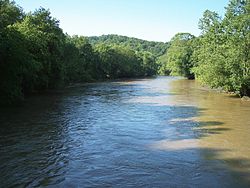 The Mohican River in northwestern Coshocton County, Ohio | |
| Location | |
| Country | United States |
| Physical characteristics | |
| Source | |
| - location | confluence of Black and Clear Forks near Loudonville |
| - coordinates | 40°36′29″N 82°15′14″W / 40.60806°N 82.25389°W / 40.60806; -82.25389[1] |
| Mouth | |
- location | Walhonding River, northwestern Coshocton County |
- coordinates | 40°21′36″N 82°09′37″W / 40.36000°N 82.16028°W / 40.36000; -82.16028Coordinates: 40°21′36″N 82°09′37″W / 40.36000°N 82.16028°W / 40.36000; -82.16028[1] |
| Length | approximately 40 mi (64 km) |
| Basin size | 999 sq mi (2,590 km2) |

Map of the Walhonding watershed showing the Mohican River and its tributaries
The Mohican River is a principal tributary of the Walhonding River, about 40 miles (64 km) long,[2] in north-central Ohio in the United States. Via the Walhonding, Muskingum and Ohio Rivers, it is part of the watershed of the Mississippi River, draining an area of 999 square miles (2,587 km²).[3]
The Mohican River is formed in Ashland County, about 2 miles (3 km) southwest of Loudonville,[4] by the confluence of the Black Fork and the Clear Fork.[1] It then flows generally south-southeast through western Holmes and northeastern Knox Counties, past the community of Brinkhaven, into northwestern Coshocton County, where it joins the Kokosing River to form the Walhonding River.[4] It collects the Lake Fork in Holmes County.[4]
Near Brinkhaven the river is spanned by the Bridge of Dreams, the second longest covered bridge in Ohio.
Variant names and spellings
The river was named after the Mohican Indian tribe.[5] According to the Geographic Names Information System, the Mohican River has also been known historically as:[1]
- Margrets Creek
- Mohecan Creek
- Mohiccan Creek
- Mohiccan John Creek
- Mohiccon Creek
- Mohickan Creek
- Mohickin Johns River
See also
- List of rivers of Ohio
References
^ abcd U.S. Geological Survey Geographic Names Information System: Mohican River
^ Columbia Gazetteer of North America entry
^ Ohio Department of Natural Resources. A Guide to Ohio Streams. Chapter 10: Major Ohio Watersheds (pdf)
^ abc DeLorme (1991). Ohio Atlas & Gazetteer. Yarmouth, Maine: DeLorme. .mw-parser-output cite.citation{font-style:inherit}.mw-parser-output q{quotes:"""""""'""'"}.mw-parser-output code.cs1-code{color:inherit;background:inherit;border:inherit;padding:inherit}.mw-parser-output .cs1-lock-free a{background:url("//upload.wikimedia.org/wikipedia/commons/thumb/6/65/Lock-green.svg/9px-Lock-green.svg.png")no-repeat;background-position:right .1em center}.mw-parser-output .cs1-lock-limited a,.mw-parser-output .cs1-lock-registration a{background:url("//upload.wikimedia.org/wikipedia/commons/thumb/d/d6/Lock-gray-alt-2.svg/9px-Lock-gray-alt-2.svg.png")no-repeat;background-position:right .1em center}.mw-parser-output .cs1-lock-subscription a{background:url("//upload.wikimedia.org/wikipedia/commons/thumb/a/aa/Lock-red-alt-2.svg/9px-Lock-red-alt-2.svg.png")no-repeat;background-position:right .1em center}.mw-parser-output .cs1-subscription,.mw-parser-output .cs1-registration{color:#555}.mw-parser-output .cs1-subscription span,.mw-parser-output .cs1-registration span{border-bottom:1px dotted;cursor:help}.mw-parser-output .cs1-hidden-error{display:none;font-size:100%}.mw-parser-output .cs1-visible-error{font-size:100%}.mw-parser-output .cs1-subscription,.mw-parser-output .cs1-registration,.mw-parser-output .cs1-format{font-size:95%}.mw-parser-output .cs1-kern-left,.mw-parser-output .cs1-kern-wl-left{padding-left:0.2em}.mw-parser-output .cs1-kern-right,.mw-parser-output .cs1-kern-wl-right{padding-right:0.2em}
ISBN 0-89933-233-1.
^ Gannett, Henry (1905). The Origin of Certain Place Names in the United States. U.S. Government Printing Office. p. 211.
This article related to a river in Ohio is a stub. You can help Wikipedia by expanding it. |


