Hormigueros, Puerto Rico
Hormigueros, Puerto Rico | ||
|---|---|---|
Town and Municipality | ||
 | ||
| ||
| Nickname(s): "El Pueblo de Nuestra Señora de la Monserrate", "El Pueblo del Milagro", "Los Peregrinos", "Corazón del Oeste" | ||
| Anthem: "Sobre un verde valle de mi linda Borinquén" | ||
 Location of Hormigueros in Puerto Rico | ||
| Coordinates: 18°08′23″N 67°07′39″W / 18.13972°N 67.12750°W / 18.13972; -67.12750Coordinates: 18°08′23″N 67°07′39″W / 18.13972°N 67.12750°W / 18.13972; -67.12750 | ||
| Country | United States | |
| Territory | Puerto Rico | |
| Founded | 1692 | |
| Government | ||
| • Mayor | Hon. Pedro García Figueroa | |
| • Senatorial dist. | 4 - Mayagüez | |
| • Representative dist. | 20 | |
| Area | ||
| • Total | 11 sq mi (29 km2) | |
| • Land | 11 sq mi (29 km2) | |
| • Water | 0 sq mi (0 km2) | |
| Population (2010) | ||
| • Total | 17,250 | |
| • Density | 1,500/sq mi (590/km2) | |
| Demonym(s) | Hormiguereños | |
| Time zone | UTC−4 (AST) | |
| Zip code | 00660 | |

Hormigueros (Spanish pronunciation: [oɾmiˈɣeɾos]) is a municipality of Puerto Rico (U.S.) located in the western region of the island, northeast of Cabo Rojo; northwest of San Germán; and south of Mayagüez. Hormigueros is spread over 5 wards and Hormigueros Pueblo (the downtown area and the administrative center). It is part of the Mayagüez Metropolitan Statistical Area.
Contents
1 History
2 Symbols
2.1 Flag
2.2 Coat of Arms
2.3 Name
3 Geography
3.1 Climate
3.2 Barrios
4 Culture
4.1 Tourism
5 Demographics
6 Government
7 Education
7.1 Higher Education
8 Transportation
9 See also
10 References
11 External links
History
The region of what is now Hormigueros belonged to the Guaynia region, located on the southernwest portion of Puerto Rico. Archaeological findings have established that there were tribes already settled in the region around 820 BC.
During the Spanish colonization at the beginning of the 16th century, it is possible that some of them settled in the area. A coffin found underground a basilica was tested in laboratories and was dated prior to 1600. Some historians also mentioned the Horomico river as one of the main sources of gold during the rush of the era. In 1692, the town of Hormigueros was first established, first as a village of Mayagüez.[1]
For a short time, in 1898, Hormigueros became a barrio of Mayagüez, before it again became its own municipality.[2][1]
Symbols
Flag
The town's flag is based on the towns shield. It consists of a blue cloth with a horizontal white rhombus. Superposed on the white rhombus is another blue rhombus with a white globe outlined in blue with a cross. The globe with the cross symbolises royalty and represents Christ's domain over the world. This symbol is a traditional attribute to the Virgin of Montserrat.[1]
Coat of Arms
The town's shield is formed by a blue rhombus, with silver-plated edge. On the blue bottom there's a green hill which is a representation of Our Lady of Monserrate de Hormigueros' Sanctuary, with its silver stairway. The border has symmetrical black dots, on guard. On the top of the shield resides a crown formed by a wall, with three towers that have blue doors and windows. The joints of the stones are filled with blue lines. The shield is surrounded by two chains that begin at the crown and finish under the bottom part of the shield with the last links broken.[1]
Name
The name of Hormigueros means "anthill" in English. The town possibly derives its name from three concepts. The first one refers to the crowds that gathered at the Basilica Menor on September 8 to honor the Virgin of Montserrat. The second refers to the topographic formation of the town which consists of countless hills resembling "anthills", reason why it was called "Valle del Hormiguero" or "Anthill Valley". Third, it is possible that the name was originated from a Taíno word: Horomico, which means "río de oro" or "river of gold" due to the importance of the rivers in the area during the gold rush of the Spanish colonization.[1]
Geography
The municipality of Hormigueros can be divided in three areas: the northern mountainous region that covers one fourth of the town, with hills of relative height; a semi-mountainous region that extends from east to west covering downtown Hormigueros; and the flat, valley-like region that extends towards the south covering 5.6 square miles.[1]
Climate
The climate conditions of Hormigueros are hot and humid. The average temperature is of 72 to 79 °F (22 to 26 °C).
Barrios
Like all municipalities of Puerto Rico, Hormigueros is subdivided into barrios.[3][4][5][6]
- Benavente
- Guanajibo
- Hormigueros
Hormigueros barrio-pueblo[7]
- Jaguitas
- Lavadero
These residential areas are located outside Hormigueros downtown:
- Buenaventura
- San Romualdo Norte
- San Romualdo Sur
- Valle Hermoso Norte
- Valle Hermoso Sur
Culture
Tourism
Despite its small size, Hormigueros still has several few attractions for visitors.[1] Some of them are:
- Birán Recreational Farm
- Central Eureka (sugar refinery)
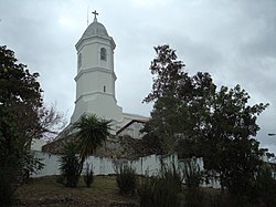
- Basilica Menor de la Virgen de Monserrate
The economy of Hormigueros is still developing. In the 1980s and '90s Allergan, Inc. (a pharmaceutical company) had a subsidiary established in town boosting the economic development of Hormigueros. However, after Allergan left no other private industry has opened operations in Hormigueros. On the other hand, Hormigueros does provide abundant land, talent and accessibility for an economic development and expansion. Not far away there are two regional airports: Eugenio María de Hostos Airport at Mayaguez and Mercedita Airport at Ponce. In addition, there is Rafael Hernández International Airport at Aguadilla. All three airports lie within 30 miles approximately.[1]
Demographics
| Historical population | ||
|---|---|---|
| Year | Pop. | ±% |
| 1950 | 6,916 | — |
| 1960 | 7,153 | +3.4% |
| 1970 | 10,827 | +51.4% |
| 1980 | 14,030 | +29.6% |
| 1990 | 15,212 | +8.4% |
| 2000 | 16,614 | +9.2% |
Hormigueros is one of the least populated municipalities of Puerto Rico, perhaps due to its small size. The population, according to the 2000 census, was 16,614 with a population density of 1,510.3 people per square mile (580.9/km²). Since the 1950s, the population has more than doubled. According to the 1950 census, there were 6,916 people living in Hormigueros.
Statistics taken from the 2000 census shows that 86.0% of Hormiguereños have Spanish or White origin, 4.9% are black, 0.2% are Amerindian etc.
| Race - Hormigueros, Puerto Rico - 2000 Census[8] | ||
|---|---|---|
| Race | Population | % of Total |
| White | 14,283 | 86.0% |
| Black/African American | 811 | 4.9% |
| American Indian and Alaska Native | 31 | 0.2% |
| Asian | 21 | 0.1% |
| Native Hawaiian/Pacific Islander | 4 | 0.0% |
| Some other race | 1,063 | 6.4% |
| Two or more races | 401 | 2.4% |
Government
After its initial establishment, Hormigueros belonged to the municipality of Mayagüez.[1] From 1863 to 1873, residents of Hormigueros made formal petitions to be separated from Mayaguez and be declared an independent municipality. They were finally granted their independence as a municipality on April 1, 1874, being its first mayor Narciso Oller Serra.
However, after the American invasion of 1898, Hormigueros was annexed this time to the town of Mayaguez. The annexation was ordered by Guy V. Henry, but according to Adolfo de Hostos, it was a town's petition.[9][dead link] In 1912, they were granted their independence once again, although there were attempts to annex them again during 1928-29.
The city belongs to the Puerto Rico Senatorial district IV, which is represented by two Senators. In 2012, Gilberto Rodríguez and María Teresa González were elected as District Senators.[10]
Education
Hormigueros boasts several public and private schools within its territory. Public education is handled by the Puerto Rico Department of Education.
Some of the local schools are:
- Escuela Elemental Nueva
- Ana Pagán
- Miguel Angel
- Giraldo González
- Ramon Rodríguez Diaz
- Segundo Ruiz Belvis
Higher Education
At the same time, most of the population (21-35) has either a bachelor or a higher degree,[citation needed] making the town one of the most talented one in the Island of Puerto Rico.[citation needed]
Transportation
Puerto Rico Highway 2 provides access to Hormigueros from the nearby city of Mayaguez, or from Ponce. The rest of the roads on the town are mostly rural.
Like most other towns in the island, it counts with a public transportation system consisting of public cars. Taxis are also available around the town.
See also
- List of Puerto Ricans
- History of Puerto Rico
- Did you know-Puerto Rico?
References
^ abcdefghi Hormigueros: History and Founding. Encyclopedia Puerto Rico. Retrieved 21 October 2012.
^ "Mapa de los municipios de Mayagüez y Hormigueros". archivonacional.com (in Spanish). Retrieved 12 January 2019..mw-parser-output cite.citation{font-style:inherit}.mw-parser-output q{quotes:"""""""'""'"}.mw-parser-output code.cs1-code{color:inherit;background:inherit;border:inherit;padding:inherit}.mw-parser-output .cs1-lock-free a{background:url("//upload.wikimedia.org/wikipedia/commons/thumb/6/65/Lock-green.svg/9px-Lock-green.svg.png")no-repeat;background-position:right .1em center}.mw-parser-output .cs1-lock-limited a,.mw-parser-output .cs1-lock-registration a{background:url("//upload.wikimedia.org/wikipedia/commons/thumb/d/d6/Lock-gray-alt-2.svg/9px-Lock-gray-alt-2.svg.png")no-repeat;background-position:right .1em center}.mw-parser-output .cs1-lock-subscription a{background:url("//upload.wikimedia.org/wikipedia/commons/thumb/a/aa/Lock-red-alt-2.svg/9px-Lock-red-alt-2.svg.png")no-repeat;background-position:right .1em center}.mw-parser-output .cs1-subscription,.mw-parser-output .cs1-registration{color:#555}.mw-parser-output .cs1-subscription span,.mw-parser-output .cs1-registration span{border-bottom:1px dotted;cursor:help}.mw-parser-output .cs1-hidden-error{display:none;font-size:100%}.mw-parser-output .cs1-visible-error{font-size:100%}.mw-parser-output .cs1-subscription,.mw-parser-output .cs1-registration,.mw-parser-output .cs1-format{font-size:95%}.mw-parser-output .cs1-kern-left,.mw-parser-output .cs1-kern-wl-left{padding-left:0.2em}.mw-parser-output .cs1-kern-right,.mw-parser-output .cs1-kern-wl-right{padding-right:0.2em}
^ Picó, Rafael; Buitrago de Santiago, Zayda; Berrios, Hector H. Nueva geografía de Puerto Rico: física, económica, y social, por Rafael Picó. Con la colaboración de Zayda Buitrago de Santiago y Héctor H. Berrios. San Juan Editorial Universitaria, Universidad de Puerto Rico,1969.
^ Gwillim Law (20 May 2015). Administrative Subdivisions of Countries: A Comprehensive World Reference, 1900 through 1998. McFarland. p. 300. ISBN 978-1-4766-0447-3. Retrieved 25 December 2018.
^ Puerto Rico:2010:population and housing unit counts.pdf (PDF). U.S. Dept. of Commerce, Economics and Statistics Administration, U.S. Census Bureau. 2010.
^ "Map of Hormigueros at the Wayback Machine" (PDF). Retrieved 2018-12-29.
^ "US Census Barrio-Pueblo definition". factfinder.com. US Census. Retrieved 5 January 2019.
^ Ethnicity 2000 census
^ "Hormigueros" (in Spanish). Municipality of Hormigueros.
^ "Senadores por Distrito" [Senators by District] (in Spanish). Comisión Estatal de Elecciones de Puerto Rico. 12 December 2012. Archived from the original on 4 August 2013. Retrieved 17 February 2016.
External links
- Welcome to Puerto Rico! Hormigueros
Places adjacent to Hormigueros, Puerto Rico | ||||||||||
|---|---|---|---|---|---|---|---|---|---|---|
| ||||||||||
San Juan (capital) | |
| Metropolitan areas |
|
| Municipalities |
|
| Islands |
|
| Geography |
|


