Quebradillas, Puerto Rico
Quebradillas, Puerto Rico | ||
|---|---|---|
City and Municipality | ||
 View of the Guajataca Tunnel and coast line of Guajataca Beach | ||
| ||
| Nickname(s): "La Guarida del Pirata", "La Ciudad Pirata", "La Ciudad del Cooperativismo", "El Rincón de Guajataca" | ||
| Anthem: "De lejos canto, porque anhela el corazón" | ||
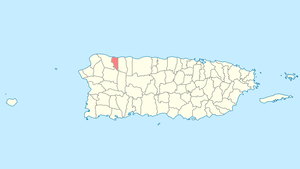 Location of Quebradillas in Puerto Rico | ||
| Coordinates: 18°28′26″N 66°56′19″W / 18.47389°N 66.93861°W / 18.47389; -66.93861Coordinates: 18°28′26″N 66°56′19″W / 18.47389°N 66.93861°W / 18.47389; -66.93861 | ||
| Country | United States | |
| Territory | Puerto Rico | |
| Founded | June 7, 1823 | |
| Government | ||
| • Mayor | Hon. Heriberto Velez Velez (PPD) | |
| • Senatorial dist. | 3 - Arecibo | |
| • Representative dist. | 15 | |
| Area | ||
| • Total | 27.7 sq mi (71.66 km2) | |
| • Land | 23.2 sq mi (60 km2) | |
| • Water | 4.5 sq mi (11.66 km2) | |
| Population (2010) | ||
| • Total | 25,919 | |
| • Density | 940/sq mi (360/km2) | |
| Demonym(s) | Quebradillanos | |
| Time zone | UTC−4 (AST) | |
| Zip code | 00678 | |
| Website | www.quebradillas.pr.gov | |
Quebradillas (Spanish pronunciation: [keβɾaˈðiʎas]) is a municipality of the island of Puerto Rico (U.S.), located in the north-western shore bordering the Atlantic Ocean, north of San Sebastián; east of Isabela; and west of Camuy. Quebradillas is spread over seven wards and Quebradillas Pueblo (The downtown area and the administrative center of the city). It is part of the San Juan-Caguas-Guaynabo Metropolitan Statistical Area.
Quebradillas is called "La Guarida del Pirata" (The Pirate's Hideout). A well known beach in the area, Puerto Hermina, is home to an old structure known to have been a hiding place for pirates and their contraband.
Contents
1 History
2 Geography
2.1 Barrios
3 Climate
4 Tourism
4.1 Landmarks and places of interest
5 Economy
5.1 Business
6 Culture
6.1 Festivals and Events
6.2 Sports
7 Government
8 Symbols
8.1 Flag
8.2 Coat of Arms
9 Education
10 Public Schools
11 Private Schools
12 See also
13 References
14 External links
History
The town was founded in 1823 by Felipe Ruiz. This town derives its name from the large amount of streams flowing through it. The name literally means "small streams".
Geography
Quebradillas is home to one of the 20 designated forest preserves in Puerto Rico, the Guajataca Forest. The forest serves as a great example of an unusual topography known as karst country. Karst is characterized by dissolved limestone formations such as sinkholes and haystack-shaped hills known as "mogotes". It is also home to the beautiful man-made reservoir, Guajataca Lake (2.5 mi or 4.0 km long), where you can fish for largemouth bass, peacock bass, tilapia and bluegill (in Spanish known as "chopa"). You can also go hiking or camping. The Boy Scouts of America maintain a campground on the lake known as Camp Guajataca. The name Guajataca comes from the name of a Taíno Indian chief who lived in this area. This Indian chief also gives his name to Guajataca Beach to the north where Río Guajataca flowing from Guajataca Lake meets the Atlantic Ocean. Guajataca Beach is popular with surfers and is known for its white sands and wild waters. This beach is ideal for sunning and collecting seashells.
Barrios
Like all municipalities of Puerto Rico, Quebradillas is subdivided into barrios.[1][2][3]
- Cacao
- Charcas
- Cocos
- Guajataca
Quebradillas barrio-pueblo[4]
- San Antonio
- San José
- Terranova
Climate
The general climate of the town is subtropical.
| Climate data for Quebradillas, Puerto Rico | |||||||||||||
|---|---|---|---|---|---|---|---|---|---|---|---|---|---|
| Month | Jan | Feb | Mar | Apr | May | Jun | Jul | Aug | Sep | Oct | Nov | Dec | Year |
| Average high °F (°C) | 82.5 (28.1) | 82.8 (28.2) | 83.6 (28.7) | 84.6 (29.2) | 85.8 (29.9) | 86.8 (30.4) | 87.1 (30.6) | 87.4 (30.8) | 87.7 (30.9) | 87.5 (30.8) | 85.8 (29.9) | 84.1 (28.9) | 85.5 (29.7) |
| Average low °F (°C) | 66.3 (19.1) | 65.4 (18.6) | 66.1 (18.9) | 67.6 (19.8) | 68.7 (20.4) | 69.9 (21.1) | 71.3 (21.8) | 71.4 (21.9) | 71.3 (21.8) | 70.1 (21.2) | 68.7 (20.4) | 67.6 (19.8) | 68.7 (20.4) |
| Average precipitation inches (mm) | 4.2 (110) | 3.0 (76) | 3.4 (86) | 4.5 (110) | 6.2 (160) | 4.8 (120) | 3.3 (84) | 4.7 (120) | 4.7 (120) | 5.0 (130) | 5.9 (150) | 5.0 (130) | 54.5 (1,380) |
| Source: Weatherbase [5] | |||||||||||||
Tourism
Landmarks and places of interest
- El Merendero (Scenic Park and Ocean Look-Out)
Guajataca Lake Reservoir (Inland)- La Cabeza del Indio (Indian Head at Puerto Hermina Beach)
- The Old Liberty Theater (Downtown)
- El Museo de Muñecas (Doll Museum)[houses over 1,000 Barbie dolls] - in Barrios Cocos
- Noah's Arc (closed)- in Barrio cocos
- Puerto Hermina Beach Pirate Ruins
- El Puente Blanco (Old White Train Bridge)
- Casa Rafols-Iribas, site of Casa de la Cultura Cacique Mabodamaca (non-profit organization dedicated to preserve the culture, the arts and the historical sites of the town of Quebradillas)
- ' Los Chorritos Pirata'' kids aquatic park
- Mini golf course
- Mosaic of nature
- Miradero Guajataca
- Race kart course (proposed)
Economy
Business
A small shopping center called Quebradillas Plaza is located in this municipality along with some manufacturing industries.
An event which negatively affected the region in the decade of the 1990s was the disappearance of tax exemptions to the private corporations [section 936 of the code of the US Internal Revenue Service ], which at the time was the ideal excuse for the closing of one of the greater manufacturers of textiles in the northwest area of the island. This decline of the industry of the needle occurred similarly in the bordering cities like Isabela and Camuy, generating a regional economic decline as the locals greatly depended on these jobs. In nearby towns like Hatillo, Mayagüez and Aguadilla, the arrival of mega stores and new shopping centers attracted the jobs that used to be in Quebradillas, helping to create the general vision of the town as "ghostly" because there is little movement in the city.
At the same time, since the Island lacks mass public transportation, people must resort to private cars (known as carro publico,public car in English) used as a bus as a mode of transportation. This, coupled with the fact that the only road to access the important cities, the Puerto Rico Highway 2, is congested most of the day, makes it difficult for people in the area to find work and thus contributes to the general economic decline.
Ironically, the town possesses one tunnel that at the beginning of the 20th century was utilized by steam driven trains that traveled throughout the Island. The disappearance of the same is considered as one of the most ironic facts of the modern history of Puerto Rico, since these railways were very extensive, built through earthly bluffs and were of great utility. Today, their absence only aggravates the problem of mass transit and the dependence on privately owned vehicles as the only method of transportation.
The economy, entering into the 21st century, is based on the sale of retail. Many small businesses are located along the two main thoroughfares that cross Quebradillas. These consist mainly of light hardware, bakeries, pharmacies, seafood restaurants, American fast food chains such as (subway, pizza hut, and burger king) near the center of town and workshops of automobile service.
The town also contains branches of various banks including Banco Popular and local savings and credit Unions. These credit unions are most noted for their involvement in common and cultural activities, sponsoring and participating in festivals of typical music [Festival of the Gourd in December], sports and educational activities.
Culture
Festivals and Events
- Three Kings Wake - January
- Guajataka Downhill Races & Music Fest - January
- Kite Festival - February
- Guajataca Carnival - February
- Patron Celebrations - October
- Competition and Festival of the Güiro "Goyo el de Bironcho" - December
Sports
The town's official basketball team is Los Piratas'[6] who have won a dramatic number of tournaments in the past. Presently the team has made a "comeback" and has won the championship of the island (2013).
- Basketball teams
- Surfing - Guajataca Beach and Puerto Hermina (Pirates Cove)
- Skateboarding - San Jose Skatepark
- Baseball - Los Cocos Park
- Longboarding
Government
The town's government is a small unit with few powers it can execute.Small elections are hosted in specific schools every four years to choose a town mayor.
Symbols
Flag
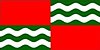
It has two red quarters. The red stands for struggle, effort and sacrifice. The other two quarters have each five green and white stripes, similar to those that appear in the shield.
Coat of Arms
The three waved stripes represent the quebradillas, over the green background of the vegetation. The fish and the walking stick (distinctive of the traveler), are insignias of San Rafael Arcángel, by allusion from the episodes narrated in the book of Tobías in the Old Testament.
Education
The town features many public and private schools. There is also a public electronic library near Los Chorritos Pirata water park.
New schools have been created thanks to a government initiative to have "21st century" schools.
Public Schools
- Manuel Ramos Hernandez
- Juan Alejo de Arizmendi
- Eugenio Maria De Hostos
- Luis Muñoz Rivera
- Honorio Hernandez
- Pedro Albizu Campos
- Ramon E. Betancez
- Ramon Avila Molinari
- Ramon Saavedra
- Jose De Diego
Private Schools
- Colegio San Rafael
- Soles del Jardín
- Pequeños Aprendiendo
See also
Quebradillas Limestone — limestone rock formation in area.- San Juan–Caguas–Guaynabo metropolitan area topics
- Did you know—Puerto Rico?
References
^ Gwillim Law (20 May 2015). Administrative Subdivisions of Countries: A Comprehensive World Reference, 1900 through 1998. McFarland. p. 300. ISBN 978-1-4766-0447-3. Retrieved 25 December 2018..mw-parser-output cite.citation{font-style:inherit}.mw-parser-output q{quotes:"""""""'""'"}.mw-parser-output code.cs1-code{color:inherit;background:inherit;border:inherit;padding:inherit}.mw-parser-output .cs1-lock-free a{background:url("//upload.wikimedia.org/wikipedia/commons/thumb/6/65/Lock-green.svg/9px-Lock-green.svg.png")no-repeat;background-position:right .1em center}.mw-parser-output .cs1-lock-limited a,.mw-parser-output .cs1-lock-registration a{background:url("//upload.wikimedia.org/wikipedia/commons/thumb/d/d6/Lock-gray-alt-2.svg/9px-Lock-gray-alt-2.svg.png")no-repeat;background-position:right .1em center}.mw-parser-output .cs1-lock-subscription a{background:url("//upload.wikimedia.org/wikipedia/commons/thumb/a/aa/Lock-red-alt-2.svg/9px-Lock-red-alt-2.svg.png")no-repeat;background-position:right .1em center}.mw-parser-output .cs1-subscription,.mw-parser-output .cs1-registration{color:#555}.mw-parser-output .cs1-subscription span,.mw-parser-output .cs1-registration span{border-bottom:1px dotted;cursor:help}.mw-parser-output .cs1-hidden-error{display:none;font-size:100%}.mw-parser-output .cs1-visible-error{font-size:100%}.mw-parser-output .cs1-subscription,.mw-parser-output .cs1-registration,.mw-parser-output .cs1-format{font-size:95%}.mw-parser-output .cs1-kern-left,.mw-parser-output .cs1-kern-wl-left{padding-left:0.2em}.mw-parser-output .cs1-kern-right,.mw-parser-output .cs1-kern-wl-right{padding-right:0.2em}
^ Puerto Rico:2010:population and housing unit counts.pdf (PDF). U.S. Dept. of Commerce, Economics and Statistics Administration, U.S. Census Bureau. 2010.
^ "Map of Quebradillas" (PDF). Archived (PDF) from the original on 2011-06-08. Retrieved 2007-12-18.
^ "US Census Barrio-Pueblo definition". factfinder.com. US Census. Retrieved 5 January 2019.
^ "Weatherbase: Historical Weather for Quebradillas, Puerto Rico". Weatherbase. 2011. Archived from the original on 2016-03-04. Retrieved 2011-11-25.
Retrieved on November 24, 2011.
^ Look for quebradillas "The pirates" for the main page.
External links
| Wikimedia Commons has media related to Guajataca Tunnel. |
- Lexjuris
- Welcome to Puerto Rico!
- Quebradillas Municipality on Facebook
- Puerto Rico government directory of municipalities - Quebradillas page
San Juan (capital) | |
| Metropolitan areas |
|
| Municipalities |
|
| Islands |
|
| Geography |
|


