Morovis, Puerto Rico
Morovis, Puerto Rico | ||
|---|---|---|
Town and Municipality | ||
 | ||
| ||
| Nickname(s): "La Isla Menos Morovis" or "the island but Morovis" | ||
| Anthem: "Oh Morovis, tu vives latente" | ||
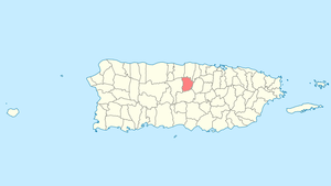 Location of Morovis in Puerto Rico | ||
| Coordinates: 18°20′00″N 66°25′00″W / 18.33333°N 66.41667°W / 18.33333; -66.41667Coordinates: 18°20′00″N 66°25′00″W / 18.33333°N 66.41667°W / 18.33333; -66.41667 | ||
| Country | United States | |
| Territory | Puerto Rico | |
| Founded | 1818 | |
| Government | ||
| • Mayor | Hon. Carmen Maldonado (PPD) | |
| • Senatorial dist. | 3 - Arecibo | |
| • Representative dist. | 28 | |
| Area | ||
| • Total | 38.7 sq mi (100.3 km2) | |
| Population (2010) | ||
| • Total | 32,610 | |
| • Density | 840/sq mi (330/km2) | |
| Demonym(s) | Moroveños | |
| Time zone | UTC−4 (AST) | |
| Zip code | 00687 | |
Morovis (Spanish pronunciation: [moˈɾoβis]) is a municipality of Puerto Rico (U.S.) located in the central region of the island, north of Orocovis, south of Manatí, Vega Baja and Vega Alta; east of Ciales, and west of Corozal. Morovis is spread over 13 wards and Morovis Pueblo (the downtown area and the administrative center of the city).[1] It is part of the San Juan-Caguas-Guaynabo Metropolitan Statistical Area.
Contents
1 History
2 Geography
2.1 Barrios
3 Economy
3.1 Agriculture
3.2 Industry
4 Tourism
4.1 Landmarks and places of interest
5 Culture
5.1 Festivals and events
6 Demographics
7 Government
8 Symbols
8.1 Flag
8.2 Coat of arms
9 See also
10 References
11 External links
History
Morovis's local Taino Indian Cacique (Chief) was named Orocobix and his tribe was locally known as the Jatibonicu Taino.
In 1815, a group of residents, under the leadership of Don Juan José de la Torre, began the process to separate Morovis from Manatí. In 1817, the government of Puerto Rico approved the separation, but it was not until 1818 that the requirements of a population of one thousand residents and the construction of a church and several other public buildings was fulfilled, that the town of Morovis was officially founded. In 1822, the mayorship was constructed and in 1823, the new church was built, dedicated to Nuestra Senora del Carmen on lands donated by Don Juan Evangelista Rivera. Its first mayor was Don Juan José de la Torre, with its second mayor being Don Juan Evangelista Rivera.
Morovis has a particular nickname. It was the only municipality in Puerto Rico that did not suffer from a cholera epidemic in 1853; as a result, a common phrase, "la isla menos Morovis" ("(all) the island but Morovis") was coined, which identifies the town informally in Puerto Rico. The phrase is believed by most Puerto Ricans to have a negative connotation against moroveños, while, in reality, it means the opposite.
Geography
Barrios
Like all municipalities of Puerto Rico, Morovis is subdivided into barrios.[2][3]
- Barahona
- Cuchillas
- Fránquez
- Monte Llano
- Morovis Pueblo
- Morovis Norte
- Morovis Sud
- Pasto
- Perchas
- Río Grande
- San Lorenzo
- Torrecillas
- Unibón
- Vaga
Economy
Agriculture
- Coffee and cattle
- Hydroponics "Cilantro"
Industry
- Light industry
Tourism
Landmarks and places of interest
- Agricultural Toasting
- Blue Star Stable
- Cabachuelas Caverns
- Panaderia de La Patita Echa Brick Oven
Culture
Festivals and events
- Tribute to Don Felo - May
- Half Marathon "El Jíbaro" - June
- Matron Celebrations - July
- Cuatro Festival - July
- The Island Except Morovis - December
- Innocents' Day - December
Demographics
| Race - Morovis, Puerto Rico - 2000 Census[4] | ||
|---|---|---|
| Race | Population | % of Total |
| White | 27,917 | 93.2% |
| Black/African American | 894 | 3.0% |
| American Indian and Alaska Native | 61 | 0.2% |
| Asian | 21 | 0.1% |
| Native Hawaiian/Pacific Islander | 0 | 0% |
| Some other race | 643 | 2.1% |
| Two or more races | 422 | 1.4% |
Government
Symbols
Flag
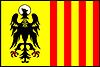
The flag of Morovis is divided vertically in two equal parts. The immediate one to the mast is yellow and has the eagle of the Coat of Arms, in this case with the head facing right toward the pole. The other half is divided in seven vertical stripes of equal width, four red ones alternated with three yellow ones.
Coat of arms
The coat of arms of the Municipality of Morovis is formed by an eagle in the left partition, which symbolizes San Juan Evangelista and sings in honor of the founder of the town, Don Juan Evangelista Rivera. The five "cuatros" (Puerto Rican instruments) observable in the right partition symbolize the fact that the town of Morovis is the main center of production of such typical Puerto Rican instruments. The shield in the center represents the Order of the Carmelite Nuns, and symbolizes as well the Virgen Carmen, matron of the town. The left half is a field of yellow color (yellow for gold) in which resides a saber (black) eagle, beak and claws in red, its head enclosed with a halo.
See also
- List of Puerto Ricans
- History of Puerto Rico
- Did you know-Puerto Rico?
References
^ "MUNICIPIO AUTÓNOMO DE MOROVIS REVISIÓN PARCIAL AL PLAN TERRITORIAL" (PDF). www.gobierno.pr. Junta de Comunidad. Archived (PDF) from the original on 2018-12-02. Retrieved 2018-12-02..mw-parser-output cite.citation{font-style:inherit}.mw-parser-output q{quotes:"""""""'""'"}.mw-parser-output code.cs1-code{color:inherit;background:inherit;border:inherit;padding:inherit}.mw-parser-output .cs1-lock-free a{background:url("//upload.wikimedia.org/wikipedia/commons/thumb/6/65/Lock-green.svg/9px-Lock-green.svg.png")no-repeat;background-position:right .1em center}.mw-parser-output .cs1-lock-limited a,.mw-parser-output .cs1-lock-registration a{background:url("//upload.wikimedia.org/wikipedia/commons/thumb/d/d6/Lock-gray-alt-2.svg/9px-Lock-gray-alt-2.svg.png")no-repeat;background-position:right .1em center}.mw-parser-output .cs1-lock-subscription a{background:url("//upload.wikimedia.org/wikipedia/commons/thumb/a/aa/Lock-red-alt-2.svg/9px-Lock-red-alt-2.svg.png")no-repeat;background-position:right .1em center}.mw-parser-output .cs1-subscription,.mw-parser-output .cs1-registration{color:#555}.mw-parser-output .cs1-subscription span,.mw-parser-output .cs1-registration span{border-bottom:1px dotted;cursor:help}.mw-parser-output .cs1-hidden-error{display:none;font-size:100%}.mw-parser-output .cs1-visible-error{font-size:100%}.mw-parser-output .cs1-subscription,.mw-parser-output .cs1-registration,.mw-parser-output .cs1-format{font-size:95%}.mw-parser-output .cs1-kern-left,.mw-parser-output .cs1-kern-wl-left{padding-left:0.2em}.mw-parser-output .cs1-kern-right,.mw-parser-output .cs1-kern-wl-right{padding-right:0.2em}
^ Gwillim Law (20 May 2015). Administrative Subdivisions of Countries: A Comprehensive World Reference, 1900 through 1998. McFarland. p. 300. ISBN 978-1-4766-0447-3. Retrieved 25 December 2018.
^ "Map of Morovis at the Wayback Machine" (PDF). Retrieved 2018-12-29.
^ "Ethnic/Racial demographics, 2000 census" (PDF). Archived (PDF) from the original on 2008-02-16. Retrieved 2008-05-27.
External links
- Welcome to Puerto Rico! Morovis
- Morovis Municipality on Facebook
San Juan (capital) | |
| Metropolitan areas |
|
| Municipalities |
|
| Islands |
|
| Geography |
|


