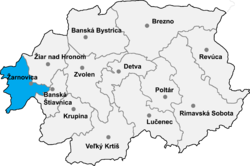
Žarnovica District
Žarnovica District | |
|---|---|
District | |
 | |
| Country | Slovakia |
Region (kraj) | Banská Bystrica Region |
| Area | |
| • Total | 426 km2 (164 sq mi) |
| Population (2001) | |
| • Total | 27,634 |
| • Density | 65/km2 (170/sq mi) |
| Time zone | UTC+1 (CET) |
| • Summer (DST) | UTC+2 (CEST) |
Žarnovica District (Slovak: okres Žarnovica) is a district in
the Banská Bystrica Region of central Slovakia. Until 1918, the district was mostly part of the county of Kingdom of Hungary of Tekov, only a part of Hodruša-Hámre, namely Banská Hodruša in the east was part of Banská Štiavnica, an urban county on the territory of Hont County.
Municipalities
- Brehy
- Hodruša-Hámre
- Horné Hámre
- Hrabičov
- Hronský Beňadik
- Kľak
- Malá Lehota
- Nová Baňa
- Orovnica
- Ostrý Grúň
- Píla
- Rudno nad Hronom
- Tekovská Breznica
- Veľká Lehota
- Veľké Pole
- Voznica
- Žarnovica
- Župkov
This Banská Bystrica Region geography article is a stub. You can help Wikipedia by expanding it. |
Districts of Banská Bystrica Region | ||
|---|---|---|
| ||
Coordinates: 48°29′18″N 18°42′28″E / 48.48833°N 18.70778°E / 48.48833; 18.70778


