Dùn, St Kilda

Multi tool use

Dùn from Ruaival with Stac Levenish in the background at left.
Dùn is an island in St Kilda, Scotland. It is nearly a mile long. Its name simply means "fort" in Scottish Gaelic (for more information, see "dun"), but the fort itself has been lost - old maps show it on Gob an Dùin (NF109972), which is at the seaward end.
Though Dùn is almost joined to Hirta at Ruiaval, the two islands are separated by Caolas an Dùin (the straits of Dùn). This prevents Soay sheep from Hirta straying onto the island, and thus it is more vegetated.
The small island is home to the largest colony of fulmars in Britain. Prior to 1828, St Kilda was their only British Isles breeding ground, but they have since spread and established colonies elsewhere, such as at Fowlsheugh.[1]

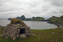
A cleit above Village Bay, Hirta. Dùn can be seen in the background

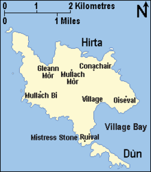
Map showing Dùn and Hirta
Dùn, which protects Village Bay on Hirta from the prevailing south-westerly winds, was at one time joined to Hirta by a natural arch. MacLean (1972) suggests that the arch was broken when struck by a galleon fleeing the defeat of the Armada, but other sources, such as Mitchell (1992), provide the more credible (if less romantic) explanation that the arch was simply swept away by one of the many fierce storms which batter the islands every winter.
See also
Cleit - a unique St Kildan form of stone shelter
- List of outlying islands of Scotland
References
^ Fisher, James & Waterston, George (Nov. 1941) The Breeding Distribution, History and Population of The Fulmar (Fulmarus glacialis) in the British Isles. Edinburgh. The Journal of Animal Ecology, Vol. 10, No. 2 pp. 204-272. Retrieved 24 March 2007
- Haswell-Smith, Hamish The Scottish Islands
- Fisher, James & Waterston, George (Nov. 1941) The Breeding Distribution, History and Population of The Fulmar (Fulmarus glacialis) in the British Isles. Edinburgh. The Journal of Animal Ecology, Vol. 10, No. 2 pp. 204–272.
- MacLean, Charles Island on the Edge of the World: the Story of St. Kilda, Canongate, 1977
 |
Wikimedia Commons has media related to Dùn. |
Islands of St Kilda (Hiort)
|
Islands |
- Boreray / Boraraigh
- Dùn
- Hirta
- Soay / Soaigh
- Stac an Armin / Stac an Àrmainn
- Stac Biorach
- Stac Lee / Stac Lì
- Stac Levenish / Stac Leibhinis
|
Endemic species |
- St Kilda dandelion
- St Kilda field mouse
St Kilda house mouse (extinct)
- St Kilda wren
|
Unique sheep breeds |
|
History |
|
Coordinates: 57°47′41″N 8°33′11″W / 57.79463°N 8.55296°W / 57.79463; -8.55296
mkh,yBKgYXvxQ0,ksHksBI qzh veE4kBsPgk0,ar
Popular posts from this blog
Place in Moyen-Ogooué, Gabon Lambaréné Street in Lambaréné Lambaréné Location in Gabon Coordinates: 0°41′18″S 10°13′55″E / 0.68833°S 10.23194°E / -0.68833; 10.23194 Coordinates: 0°41′18″S 10°13′55″E / 0.68833°S 10.23194°E / -0.68833; 10.23194 Country Gabon Province Moyen-Ogooué Population (2013 census) • Total 38,775 Lambaréné is a town and the capital of Moyen-Ogooué in Gabon. With a population of 38,775 as of 2013, it is located 75 kilometres south of the equator. Lambaréné is based in the Central African Rainforest at the river Ogooué. This river divides the city into 3 districts: Rive Gauche, Ile Lambaréné and Rive Droite. The Albert Schweitzer Hospital and the districts Adouma and Abongo are located on Rive Droite. The districts Atongowanga, Sahoty, Dakar, Grand Village, Château, Lalala and Bordamur build the Ile Lambaréné. The majority of the people in Lambaréné live in the district Isaac located on Rive Gauche. This distr...
This article is about the number. For the year, see 800. For other uses, see 800 (disambiguation). Natural number ← 799 800 801 → List of numbers — Integers ← 0 100 200 300 400 500 600 700 800 900 → Cardinal eight hundred Ordinal 800th (eight hundredth) Factorization 2 5 × 5 2 Greek numeral Ω´ Roman numeral DCCC Binary 1100100000 2 Ternary 1002122 3 Quaternary 30200 4 Quinary 11200 5 Senary 3412 6 Octal 1440 8 Duodecimal 568 12 Hexadecimal 320 16 Vigesimal 200 20 Base 36 M8 36 800 ( eight hundred ) is the natural number following 799 and preceding 801. It is the sum of four consecutive primes (193 + 197 + 199 + 211). It is a Harshad number. Contents 1 Integers from 801 to 899 1.1 800s 1.2 810s 1.3 820s 1.4 830s 1.5 840s 1.6 850s 1.7 860s 1.8 870s 1.9 880s 1.10 890s 2 References Integers from 801 to 899 800s Main article: 801...
body.skin-minerva .mw-parser-output table.infobox caption{text-align:center} 維納斯堡 Venersborg (英文) CDP Venersborg, Washington 維納斯堡位置圖 坐标: 45°46′58″N 122°27′43″W / 45.7828°N 122.462°W / 45.7828; -122.462 國家 美國 州 華盛頓州 郡 克拉克县 面积 • 总计 27.8 平方公里(10.7 平方英里) • 陸地 27.8 平方公里(10.7 平方英里) • 水域 0.0 平方公里(0.0 平方英里) 海拔 155 米(509 英尺) 人口 (2000年) • 總計 3,274 • 密度 118.0/平方公里(305.6/平方英里) 时区 PST (UTC-8) • 夏时制 PDT(UTC-7) FIPS碼 53-74585 [1] GNIS編號 1527695 [2] 維納斯堡 ( 英语: Venersborg )是美国华盛顿州克拉克县的一個普查规定居民点(CDP),2000年美國人口普查時人口為2,085人。 最初為瑞典人聚居地。 參見 維納什堡 参考資料 ^ American FactFinder. United States Census Bureau. [ 2008-01-31 ] . ^ US Board on Geographic Names. United States Geological Survey. 2007-10-25 [ 2008-01-31 ] . 查 论 编 克拉克县 行政區劃 郡治 : 溫哥華 市 巴特爾格朗德 | 卡默斯 | 拉申特 | 里奇菲尔德 | 溫哥華 | 瓦休戈 | 林地市‡ 鎮 亞科爾特 CDP 安波伊 | 巴伯頓 | 布拉什普雷里 | 櫻桃樹叢區 | ...