Oldany Island
| Meaning of name | fruit |
|---|---|
| Location | |
 Oldany Island Oldany Island shown within Scotland | |
| OS grid reference | NC088345 |
| Coordinates | 58°16′N 5°16′W / 58.26°N 5.26°W / 58.26; -5.26 |
| Physical geography | |
| Island group | Highland / Islands of Sutherland |
| Area | 200 ha[1] |
| Area rank | 109 [2] |
| Highest elevation | Sidhean nan Ealachan 104 m |
| Administration | |
| Sovereign state | United Kingdom |
| Country | Scotland |
| Council area | Highland Council |
| Demographics | |
| Population | 0 |
| References | [1][3][4][5] |
Oldany Island (formerly Oldney Island) is an uninhabited island in Assynt, Sutherland, north-west Scotland.
The name is Norse in origin and possibly means fruit.[6]
Geography
Oldany Island is a large tidal island at the southwestern entrance to Eddrachillis Bay/Kylesku. It has an area of 200 hectares (500 acres) and its highest point is Sìdhean nan Ealachan (The Swans' Fairy Mound) at 104 metres (341 ft).[1]Handa Island is to the north, across Eddrachillis Bay; Eilean Chrona is to the south west and Sgeir nan Gall (Norsemen's Skerry) is to the north. The island is part of the Assynt-Coigach National Scenic Area, one of 40 in Scotland.[7]
The settlement of Oldany is on the adjacent mainland. The island has long been used for grazing sheep. Oldany island is owned by the Turner family.[8]
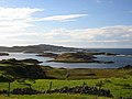
View of Oldany Island from Culkein Drumbeg (mainland), showing many of the islets to the island's east.

Oldany Island on the right, seen from the mainland (left)


References
^ abc "Overview of Oldany". Gazetteer for Scotland. Retrieved 2007-12-14..mw-parser-output cite.citation{font-style:inherit}.mw-parser-output .citation q{quotes:"""""""'""'"}.mw-parser-output .citation .cs1-lock-free a{background:url("//upload.wikimedia.org/wikipedia/commons/thumb/6/65/Lock-green.svg/9px-Lock-green.svg.png")no-repeat;background-position:right .1em center}.mw-parser-output .citation .cs1-lock-limited a,.mw-parser-output .citation .cs1-lock-registration a{background:url("//upload.wikimedia.org/wikipedia/commons/thumb/d/d6/Lock-gray-alt-2.svg/9px-Lock-gray-alt-2.svg.png")no-repeat;background-position:right .1em center}.mw-parser-output .citation .cs1-lock-subscription a{background:url("//upload.wikimedia.org/wikipedia/commons/thumb/a/aa/Lock-red-alt-2.svg/9px-Lock-red-alt-2.svg.png")no-repeat;background-position:right .1em center}.mw-parser-output .cs1-subscription,.mw-parser-output .cs1-registration{color:#555}.mw-parser-output .cs1-subscription span,.mw-parser-output .cs1-registration span{border-bottom:1px dotted;cursor:help}.mw-parser-output .cs1-ws-icon a{background:url("//upload.wikimedia.org/wikipedia/commons/thumb/4/4c/Wikisource-logo.svg/12px-Wikisource-logo.svg.png")no-repeat;background-position:right .1em center}.mw-parser-output code.cs1-code{color:inherit;background:inherit;border:inherit;padding:inherit}.mw-parser-output .cs1-hidden-error{display:none;font-size:100%}.mw-parser-output .cs1-visible-error{font-size:100%}.mw-parser-output .cs1-maint{display:none;color:#33aa33;margin-left:0.3em}.mw-parser-output .cs1-subscription,.mw-parser-output .cs1-registration,.mw-parser-output .cs1-format{font-size:95%}.mw-parser-output .cs1-kern-left,.mw-parser-output .cs1-kern-wl-left{padding-left:0.2em}.mw-parser-output .cs1-kern-right,.mw-parser-output .cs1-kern-wl-right{padding-right:0.2em}
^ Area and population ranks: there are c. 300 islands over 20 ha in extent and 93 permanently inhabited islands were listed in the 2011 census.
^ National Records of Scotland (15 August 2013) (pdf) Statistical Bulletin: 2011 Census: First Results on Population and Household Estimates for Scotland - Release 1C (Part Two). "Appendix 2: Population and households on Scotland’s inhabited islands". Retrieved 17 August 2013.
^ Haswell-Smith, Hamish. (2004) The Scottish Islands. Edinburgh. Canongate.
^ Ordnance Survey: Landranger map sheet 15 Loch Assynt (Lochinver & Kylesku) (Map). Ordnance Survey. 2012. ISBN 9780319231265.
^ "Place names Highlands & Islands of Scotland". Alex. Macbain. Retrieved 26 October 2018.
^ "National Scenic Areas" Archived 2017-03-11 at the Wayback Machine. SNH. Retrieved 30 Mar 2011.
^ "Property Page:Oldany". Who owns Scotland. Archived from the original on 2007-11-08. Retrieved 2008-01-21.
External links
| Wikimedia Commons has media related to Oldany Island. |
Coordinates: 58°15.5′N 5°15.5′W / 58.2583°N 5.2583°W / 58.2583; -5.2583
This Highland location article is a stub. You can help Wikipedia by expanding it. |


