Pichincha Province
| Pichincha | |||
|---|---|---|---|
| Province | |||
| Province of Pichincha | |||
| |||
 Location of Pichincha in Ecuador. | |||
 Cantons of Pichincha Province | |||
| Country | Ecuador | ||
| Established | 1824 | ||
| Named for | Pichincha volcano | ||
| Capital | Quito | ||
| Cantons | List of Cantons
| ||
| Government | |||
| • Provincial Prefect | Gustavo Baroja Narváez | ||
| Area | |||
| • Total | 9,535.91 km2 (3,681.84 sq mi) | ||
| Population (2010 census) | |||
| • Total | 2,576,287 | ||
| • Density | 270/km2 (700/sq mi) | ||
| Time zone | UTC-5 (ECT) | ||
| Vehicle registration | P | ||
| Website | www.pichincha.gov.ec | ||


Pichincha (Spanish pronunciation: [piˈtʃintʃa]) is a province of Ecuador located in the northern sierra region; its capital and largest city is Quito. It is bordered by Imbabura and Esmeraldas to the north, Cotopaxi and Santo Domingo de los Tsáchilas to the south, Napo and Sucumbíos to the east, and Esmeraldas and Santo Domingo de los Tsáchilas to the west.
Prior to 2008, the canton Santo Domingo de los Colorados was part of the Pichincha Province. It has since become its own province, Santo Domingo de los Tsáchilas.
The province is home to many rose plantations, which make up the bulk of Ecuador's floriculture industry.[1]
Contents
1 Administrative divisions
2 Surnames
3 Gallery
4 See also
5 References
6 External links
Administrative divisions
The province is divided into eight cantons.
| Canton | Pop. (2001) | Area (km²) | Cantonization | Capital |
|---|---|---|---|---|
Cayambe | 69,800 | 1,187 | July 23, 1883 | Cayambe |
Mejía | 62,888 | 1,459 | July 23, 1883 | Machachi |
Pedro Moncayo | 25,594 | 333 | Sep. 26, 1911 | Tabacundo |
Pedro Vicente Maldonado | 9,965 | 657 | Jan. 28, 1992 | Pedro Vicente Maldonado |
Puerto Quito | 17,100 | 719 | Apr. 1, 1996 | Puerto Quito |
Quito | 1,839,853 | 4,204 | Dec. 6, 1534 | Quito |
Rumiñahui | 65,882 | 134 | May 31, 1938 | Sangolquí |
San Miguel de Los Bancos | 10,717 | 801 | Feb. 14, 1991 | San Miguel de los Bancos |
Surnames
The most common surnames in Pichincha Province and their frequencies as of 2014:[2]
- 1. Sánchez (1:109)
- 2. López (1:111)
- 3. Rodríguez (1:127)
- 4. García (1:140)
- 5. Flores (1:154)
- 6. Pérez (1:165)
- 7. Torres (1:166)
- 8. Morales (1:177)
- 9. Salazar (1:191)
- 10. Díaz (1:204)
Gallery
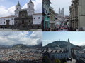
Historic centre of Quito, first World Heritage Site

The Presidential Palace in colonial Quito, Carondelet Palace, with a double decker tourist bus

Casa Gangotena located in the Historic Center of Quito facing the Plaza San Francisco, a World Heritage Site by UNESCO
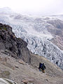
Cayambe volcano


Panoramic view from Wawa Pichincha: (from left) Ilaló, Antisana, Sincholagua, Quilindaña, Pasochoa, Cotopaxi, Rumiñawi, Atacazo, Corazón and Illinizas
See also
- Provinces of Ecuador
- Cantons of Ecuador
- Centro de Levantamientos Integrados de Recursos Naturales por Sensores Remotos
- Santa Lucia Cloud Forest
References
^ Conefrey, Mick (April 10, 2015). "Roses with altitude: why Ecuador's flower industry stands out". Financial Times. Retrieved 30 July 2017..mw-parser-output cite.citation{font-style:inherit}.mw-parser-output q{quotes:"""""""'""'"}.mw-parser-output code.cs1-code{color:inherit;background:inherit;border:inherit;padding:inherit}.mw-parser-output .cs1-lock-free a{background:url("//upload.wikimedia.org/wikipedia/commons/thumb/6/65/Lock-green.svg/9px-Lock-green.svg.png")no-repeat;background-position:right .1em center}.mw-parser-output .cs1-lock-limited a,.mw-parser-output .cs1-lock-registration a{background:url("//upload.wikimedia.org/wikipedia/commons/thumb/d/d6/Lock-gray-alt-2.svg/9px-Lock-gray-alt-2.svg.png")no-repeat;background-position:right .1em center}.mw-parser-output .cs1-lock-subscription a{background:url("//upload.wikimedia.org/wikipedia/commons/thumb/a/aa/Lock-red-alt-2.svg/9px-Lock-red-alt-2.svg.png")no-repeat;background-position:right .1em center}.mw-parser-output .cs1-subscription,.mw-parser-output .cs1-registration{color:#555}.mw-parser-output .cs1-subscription span,.mw-parser-output .cs1-registration span{border-bottom:1px dotted;cursor:help}.mw-parser-output .cs1-hidden-error{display:none;font-size:100%}.mw-parser-output .cs1-visible-error{font-size:100%}.mw-parser-output .cs1-subscription,.mw-parser-output .cs1-registration,.mw-parser-output .cs1-format{font-size:95%}.mw-parser-output .cs1-kern-left,.mw-parser-output .cs1-kern-wl-left{padding-left:0.2em}.mw-parser-output .cs1-kern-right,.mw-parser-output .cs1-kern-wl-right{padding-right:0.2em}
^ Most common surnames in Pichincha Province
Gobierno de la Provincia Pichincha Web site of the Pichincha prefecture
Data of Pichincha Geographical Data of the Province. Web site of the Pichincha Prefecture
External links
Provincial Prefecture's official page (in Spanish)
|
Coordinates: 0°15′S 78°35′W / 0.250°S 78.583°W / -0.250; -78.583


