Bayannur
Bayannur .mw-parser-output .nobold{font-weight:normal} 巴彦淖尔市 • .mw-parser-output .font-mong{font-family:"Menk Hawang Tig","Menk Qagan Tig","Menk Garqag Tig","Menk Har_a Tig","Menk Scnin Tig","Oyun Gurban Ulus Tig","Oyun Qagan Tig","Oyun Garqag Tig","Oyun Har_a Tig","Oyun Scnin Tig","Oyun Agula Tig","Mongolian BT","Mongolian Baiti","Noto Sans Mongolian","Mongol Usug","Mongolian White","MongolianScript","Code2000","Menksoft Qagan"}.mw-parser-output .font-mong-mnc,.mw-parser-output .font-mong:lang(mnc-Mong),.mw-parser-output .font-mong:lang(dta-Mong),.mw-parser-output .font-mong:lang(sjo-Mong){font-family:"Abkai Xanyan","Abkai Xanyan LA","Abkai Xanyan VT","Abkai Xanyan XX","Abkai Xanyan SC","Abkai Buleku","Daicing White","Oyun Gurban Ulus Tig","Oyun Qagan Tig","Oyun Garqag Tig","Oyun Har_a Tig","Oyun Scnin Tig","Oyun Agula Tig","Mongolian BT","Mongolian Baiti","Noto Sans Mongolian"} ᠪᠠᠶᠠᠨᠨᠠᠭᠤᠷ ᠬᠣᠲᠠ | |
|---|---|
Prefecture-level city | |
 Linhe District, the seat of Bayannur | |
 Location of Bayannur City jurisdiction in Inner Mongolia | |
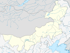  Bayannur Location of the city centre in Inner Mongolia | |
| Coordinates: 40°44′35″N 107°23′13″E / 40.743°N 107.387°E / 40.743; 107.387Coordinates: 40°44′35″N 107°23′13″E / 40.743°N 107.387°E / 40.743; 107.387 | |
| Country | People's Republic of China |
| Region | Inner Mongolia |
| Government | |
| • CPC Secretary | Nashunmenghe |
| • Mayor | He Yonglin |
| Area | |
| • Prefecture-level city | 65,788 km2 (25,401 sq mi) |
| • Urban (2018)[1] | 135 km2 (52 sq mi) |
| Population (2010) | |
| • Prefecture-level city | 1,669,915 |
| • Density | 25/km2 (66/sq mi) |
| • Urban (2018)[2] | 535,000 |
| • Urban density | 4,000/km2 (10,000/sq mi) |
| Time zone | UTC+8 (China Standard) |
| Postal code | 015000 |
| Area code(s) | 0478 |
| ISO 3166 code | CN-NM-08 |
| Website | bynr.gov.cn |
| Bayannur | |||||||||||
| Chinese name | |||||||||||
|---|---|---|---|---|---|---|---|---|---|---|---|
| Simplified Chinese | 巴彦淖尔 | ||||||||||
| Traditional Chinese | 巴彥淖爾 | ||||||||||
| |||||||||||
| Mongolian name | |||||||||||
| Mongolian Cyrillic | Баяннуур хот | ||||||||||
| Mongolian script | ᠪᠠᠶᠠᠨᠨᠠᠭᠤᠷ ᠬᠣᠲᠠ | ||||||||||
| |||||||||||
Bayannur or Bayannao'er (Mongolian:
ᠪᠠᠶᠠᠨᠨᠠᠭᠤᠷ ᠬᠣᠲᠠ Bayannaɣur qota; Chinese: 巴彦淖尔市; pinyin: bāyànnàoěr) is a prefecture-level city in western Inner Mongolia, People's Republic of China. Until December 1, 2003, the area was called Bayannur League.
Bayannur has an administrative area of 65,788 km2 (25,401 sq mi). The name of the city in Mongolian means "Rich Lake". At the 2010 census, the total population of Bayannur is up to 1,669,915, while the city proper, Linhe District, has 520,300 inhabitants.[3]
Contents
1 History
2 Geography and climate
3 Demographics
4 Administrative Subdivisions
5 Cuisine
6 References
7 External links
History
The Zhao Dynasty (403 BCE–222 BCE) controlled an area including modern-day Bayannur, while the Western Han Dynasty (206 BCE–24 CE) established a hierarchical Chinese administrative structure. The Qing Dynasty (1644–1912) designated this area as part of "Inner Mongolia", but after its overthrow by the Republic of China (1912-1949), Bayannur was assigned to Suiyuan Province. Because of Mongol-Chinese cooperation with the Communist faction in the Chinese Civil War (stalled since 1950), Suiyuan was annexed to the new Inner Mongolia Autonomous Region from 1954, although not without controversy because of the province's large and longstanding ethnic Han majority.
Geography and climate
Bayannur is located in the western part of inner Mongolia Autonomous region. Neighbouring prefectures are:
Baotou (E)
Alxa (W)
Ordos (S)
It also borders Mongolia to the north. The whole area of the prefecture is 65,788 km2 (25,401 sq mi) at present and the total population is nearly 1.7 million. Bayannur features a desert climate (Köppen BWk), marked by long, cold and very dry winters, very warm, somewhat humid summers, and strong winds, especially in spring. Most of the rain falls between July and September, with very little snow in winter.
| Climate data for Bayannur (1971−2000) | |||||||||||||
|---|---|---|---|---|---|---|---|---|---|---|---|---|---|
| Month | Jan | Feb | Mar | Apr | May | Jun | Jul | Aug | Sep | Oct | Nov | Dec | Year |
| Record high °C (°F) | 12.3 (54.1) | 15.5 (59.9) | 22.8 (73) | 31.9 (89.4) | 36.5 (97.7) | 36.5 (97.7) | 39.4 (102.9) | 37.9 (100.2) | 36.0 (96.8) | 27.5 (81.5) | 19.2 (66.6) | 12.4 (54.3) | 39.4 (102.9) |
| Average high °C (°F) | −3.3 (26.1) | 1.4 (34.5) | 8.5 (47.3) | 17.5 (63.5) | 24.6 (76.3) | 28.8 (83.8) | 30.7 (87.3) | 28.3 (82.9) | 23.1 (73.6) | 15.4 (59.7) | 5.6 (42.1) | −1.4 (29.5) | 14.9 (58.9) |
| Daily mean °C (°F) | −9.9 (14.2) | −5.8 (21.6) | 1.3 (34.3) | 9.9 (49.8) | 17.3 (63.1) | 22.0 (71.6) | 24.1 (75.4) | 21.9 (71.4) | 16.0 (60.8) | 8.1 (46.6) | −0.6 (30.9) | −7.4 (18.7) | 8.1 (46.5) |
| Average low °C (°F) | −15.1 (4.8) | −11.6 (11.1) | −5 (23) | 2.7 (36.9) | 9.7 (49.5) | 14.9 (58.8) | 17.9 (64.2) | 16.1 (61) | 9.8 (49.6) | 2.4 (36.3) | −5.4 (22.3) | −12.1 (10.2) | 2.0 (35.6) |
| Record low °C (°F) | −35.3 (−31.5) | −32.4 (−26.3) | −19.1 (−2.4) | −10.3 (13.5) | −3.1 (26.4) | 5.5 (41.9) | 9.0 (48.2) | 5.1 (41.2) | −2.0 (28.4) | −9.6 (14.7) | −20.0 (−4) | −24.3 (−11.7) | −35.3 (−31.5) |
| Average precipitation mm (inches) | 1.0 (0.039) | 1.1 (0.043) | 3.0 (0.118) | 4.2 (0.165) | 10.8 (0.425) | 14.3 (0.563) | 34.1 (1.343) | 47.7 (1.878) | 18.9 (0.744) | 8.5 (0.335) | 1.7 (0.067) | 0.4 (0.016) | 145.7 (5.736) |
| Average precipitation days (≥ 0.1 mm) | 0.9 | 1.2 | 1.5 | 1.5 | 3.0 | 4.4 | 7.4 | 8.1 | 4.6 | 2.3 | 1.0 | 0.6 | 36.5 |
| Source: Weather China | |||||||||||||
Demographics
In 2000, there were 1,682,662 inhabitants:
| Ethnic group | no. of inhabitants | share |
|---|---|---|
Han | 1,579,969 | 93.9% |
Mongols | 76,368 | 4.54% |
Hui | 19,835 | 1.18% |
Manchu | 4,231 | 0.25% |
Tujia | 560 | 0.03% |
Tibetans | 393 | 0.02% |
Miao | 224 | 0.01% |
Koreans | 211 | 0.01% |
Yi | 178 | 0.01% |
Daur | 166 | 0.01% |
| Other | 527 | 0.03% |
At the end of 2004, the population was at around 1,79 million inhabitants.
Administrative Subdivisions
Bayannur is divided into one district, two counties and four banners:
| Map | |||||||
|---|---|---|---|---|---|---|---|
 | |||||||
| # | Name | Mongolian | Hanzi | Hanyu Pinyin | Population (2010) | Area (km²) | Density (/km²) |
| 1 | Linhe District | ᠯᠢᠨᠾᠧ ᠲᠣᠭᠣᠷᠢᠭ (Linhė toɣoriɣ) | 临河区 | Línhé Qū | 541,721 | 2,354 | 230 |
| 2 | Wuyuan County | ᠦᠶᠤᠸᠠᠨ ᠰᠢᠶᠠᠨ (Üyuvan siyan) | 五原县 | Wǔyuán Xiàn | 260,480 | 2,493 | 104 |
| 3 | Dengkou County | ᠳ᠋ᠧᠩᠺᠧᠦ ᠰᠢᠶᠠᠨ (Dėŋḵėü siyan) | 磴口县 | Dèngkǒu Xiàn | 117,091 | 4,167 | 28 |
| 4 | Urad Front Banner (Urad Omnod Banner) | ᠤᠷᠠᠳ ᠤᠨ ᠡᠮᠦᠨᠡᠳᠦ ᠬᠣᠰᠢᠭᠤ (Urad-un Emünedü qosiɣu) | 乌拉特前旗 | Wūlātè Qián Qí | 293,269 | 7,476 | 39 |
| 5 | Urad Middle Banner (Urad Dundad Banner) | ᠤᠷᠠᠳ ᠤᠨ ᠳᠤᠮᠳᠠᠳᠤ ᠬᠣᠰᠢᠭᠤ (Urad-un Dumdadu qosiɣu) | 乌拉特中旗 | Wūlātè Zhōng Qí | 134,204 | 22,606 | 6 |
| 6 | Urad Rear Banner (Urad Hoit Banner) | ᠤᠷᠠᠳ ᠤᠨ ᠬᠣᠶᠢᠲᠤ ᠬᠣᠰᠢᠭᠤ (Urad-un Qoyitu qosiɣu) | 乌拉特后旗 | Wūlātè Hòu Qí | 65,207 | 24,925 | 2 |
| 7 | Hanggin Rear Banner (Hanggin Hoit Banner) | ᠬᠠᠩᠭᠢᠨ ᠬᠣᠶᠢᠲᠤ ᠬᠣᠰᠢᠭᠤ (Qaŋɣin Qoyitu qosiɣu) | 杭锦后旗 | Hángjǐn Hòu Qí | 257,943 | 1,767 | 145 |
Cuisine
Located in Hetao Plain, Bayannaoer is the largest agricultural hub in Inner Mongolia. Bayannaoer is famous for "Bameng braised dishes" (巴盟烩菜), meaning "braised dishes".
References
^ Cox, W (2018). Demographia World Urban Areas. 14th Annual Edition (PDF). St. Louis: Demographia. p. 82..mw-parser-output cite.citation{font-style:inherit}.mw-parser-output q{quotes:"""""""'""'"}.mw-parser-output code.cs1-code{color:inherit;background:inherit;border:inherit;padding:inherit}.mw-parser-output .cs1-lock-free a{background:url("//upload.wikimedia.org/wikipedia/commons/thumb/6/65/Lock-green.svg/9px-Lock-green.svg.png")no-repeat;background-position:right .1em center}.mw-parser-output .cs1-lock-limited a,.mw-parser-output .cs1-lock-registration a{background:url("//upload.wikimedia.org/wikipedia/commons/thumb/d/d6/Lock-gray-alt-2.svg/9px-Lock-gray-alt-2.svg.png")no-repeat;background-position:right .1em center}.mw-parser-output .cs1-lock-subscription a{background:url("//upload.wikimedia.org/wikipedia/commons/thumb/a/aa/Lock-red-alt-2.svg/9px-Lock-red-alt-2.svg.png")no-repeat;background-position:right .1em center}.mw-parser-output .cs1-subscription,.mw-parser-output .cs1-registration{color:#555}.mw-parser-output .cs1-subscription span,.mw-parser-output .cs1-registration span{border-bottom:1px dotted;cursor:help}.mw-parser-output .cs1-hidden-error{display:none;font-size:100%}.mw-parser-output .cs1-visible-error{font-size:100%}.mw-parser-output .cs1-subscription,.mw-parser-output .cs1-registration,.mw-parser-output .cs1-format{font-size:95%}.mw-parser-output .cs1-kern-left,.mw-parser-output .cs1-kern-wl-left{padding-left:0.2em}.mw-parser-output .cs1-kern-right,.mw-parser-output .cs1-kern-wl-right{padding-right:0.2em}
^ Cox, W (2018). Demographia World Urban Areas. 14th Annual Edition (PDF). St. Louis: Demographia. p. 82.
^ 2010年巴彦淖尔市第六次全国人口普查主要数据公报(Sixth National Population Census of the People's Republic of China)
External links
- Official website
Inner Mongolia topics | |
|---|---|
Hohhot (capital) | |
| General |
|
| Geography |
|
| Education |
|
| Culture |
|
| Cuisine |
|
| Visitor attractions |
|
| |
 Category
 Commons
Major cities along the Yellow River | ||
|---|---|---|
| Province-level subdivisions | Cities (from upper reaches to lower reaches) |  |
| Gansu |
| |
| Ningxia |
| |
| Inner Mongolia |
| |
| Shanxi |
| |
| Shaanxi |
| |
| Henan |
| |
| Shandong |
| |
Major cities along the Pearl River · Major cities along the Yangtze River | ||

