Ohio's 6th congressional district
| Ohio's 6th congressional district | |
|---|---|
 Ohio's 6th congressional district - since January 3, 2013. | |
| U.S. Representative | Bill Johnson (R–Marietta) |
| Distribution |
|
| Population (2016) | 703,190[2] |
| Median income | $47,067[3] |
| Ethnicity |
|
| Cook PVI | R+16[4] |
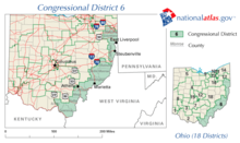
Ohio's 6th congressional district is represented by Representative Bill Johnson (R-OH). This district runs along the southeast side of the state, bordering Kentucky, West Virginia, and Pennsylvania. It stretches from rural Lucasville through Athens and several older Ohio River industrial towns all the way to the Youngstown city limits.[5]
Contents
1 History
2 List of representatives
3 Recent election results
4 Competitiveness
5 Historical district boundaries
6 See also
7 Notes and references
History
When Robert McEwen was first elected in 1980, the Sixth District of Ohio consisted of Adams, Brown, Clinton, Fayette, Highland, Pickaway, Pike, Scioto, and Ross Counties plus Clermont County outside the city of Loveland, Harrison Township in Vinton County and the Warren County townships of Clearcreek, Deerfield, Hamilton, Harlan, Massie, Salem, and Wayne.[6] At that time, The Washington Post described the Sixth as "a fail-safe Republican district."[7]
The Ohio General Assembly redrew the Sixth District following the results of the 1980 Census. The boundaries from 1983 to 1987 included all of Adams, Clinton, Fayette, Highland, Hocking, Jackson, Pike, Ross, Scioto, Vinton and Warren Counties, plus Waterloo and York Townships in Athens County; Wayne Township in Clermont County; Concord, Jasper, Marion, Perry, Union, and Wayne Townships in Fayette County; and Washington Township and the Cities of Miamisburg and West Carrollton in Montgomery County.[8]
Beginning with the 100th Congress in 1987, adjustments were made by the legislature to the boundaries; reapportionment between censuses is unusual in American politics. A small part of the Montgomery County territory was detached, as were parts of Fayette County in Washington Court House in Union Township and the townships of Jasper and Marion. Part of Brown County was added, Jackson and Eagle Townships. These were the boundaries for the rest of McEwen's service in Congress.[9]
The district was largely rural and agricultural with no large cities. One of the major industries was the United States Department of Energy's Portsmouth Gaseous Diffusion Plant at Piketon, which manufactured uranium for nuclear weapons. The district was 97 per cent white with a median household income of $21,761.[10]
In 1992, the district was altered significantly to accommodate Ohio's loss of two House seats in redistricting. The state legislature anticipated that Clarence Miller of the neighboring Tenth District would retire, and thus combined the southern end of his district (which included Athens, Gallipolis, and Ironton) with most of the area previously represented by McEwen. Although the district did not include Miller's hometown of Lancaster, Miller decided not to retire and instead challenged McEwen in the Sixth District primary in 1992. The campaign was bitter, and McEwen eked out only a narrow victory. In November, McEwen was upset by Democrat Ted Strickland, a prison psychologist. Strickland himself was defeated in 1994 by Republican Frank Cremeans, but won the seat back in 1996.
For 2002 the district was shifted dramatically eastward to make the seat friendlier for Strickland. At the same time, it effectively ended the career of James Traficant in the neighboring 17th District by placing his hometown of Poland into the 6th. Traficant opted to run in his old district and lost. The district currently includes all of Belmont, Carroll, Columbiana, Gallia, Guernsey, Jackson, Jefferson, Lawrence, Meigs, Monroe, Noble and Washington counties, and portions of Athens, Mahoning, Muskingum, Scioto and Tuscarawas counties.
In 2010, Republican Bill Johnson defeated incumbent Democrat Charles Wilson, returning the seat Republican for the first time since 1997. Following the 2010 United States Census, the bounds of the sixth district were changed again as Ohio lost two seats in Congress.[11]
In recent years and like much of coal country, the district has swung decidedly toward the Republican Party at local, state and national levels. Going from what was once a dead heat in presidential elections, such as in 2000 or 2004, to a 42-point win for Donald Trump over Hillary Clinton in 2016.
List of representatives
| Representative | Party | Year(s) | Congress(es) | Notes |
|---|---|---|---|---|
| District created | March 4, 1813 | |||
 Reasin Beall Reasin Beall | Democratic- Republican | April 20, 1813 – June 7, 1814 | 13th | Elected after Rep-elect John Stark Edwards died before commencement of term, Resigned |
 David Clendenin David Clendenin | October 11, 1814 – March 3, 1817 | 13th–14th | ||
 Peter Hitchcock Peter Hitchcock | March 4, 1817 – March 3, 1819 | 15th | ||
 John Sloane John Sloane | March 4, 1819 – March 3, 1823 | 16th–17th | Redistricted to the 12th district | |
 Duncan McArthur Duncan McArthur | Adams- Clay DR | March 4, 1823 – March 3, 1825 | 18th | |
| John Thomson | Jacksonian | March 4, 1825 – March 3, 1827 | 19th | |
 William Creighton, Jr. William Creighton, Jr. | Adams | March 4, 1827 – ????, 1828 | 20th | Resigned after being appointed as judge of United States District Court for the District of Ohio |
| Francis Swaine Muhlenberg | December 19, 1828 – March 3, 1829 | 20th | ||
| William Creighton, Jr. | Anti- Jacksonian | March 4, 1829 – March 3, 1833 | 21st–22nd | |
 Samuel Finley Vinton Samuel Finley Vinton | March 4, 1833 – March 3, 1835 | 23rd | Redistricted from the 7th district | |
Whig | March 4, 1835 – March 3, 1837 | 24th | ||
| Calvary Morris | March 4, 1837 – March 3, 1843 | 25th–27th | ||
| Henry St. John | Democratic | March 4, 1843 – March 3, 1847 | 28th–29th | |
 Rodolphus Dickinson Rodolphus Dickinson | March 4, 1847 – March 20, 1849 | 30th–31st | Died | |
| Amos E. Wood | December 3, 1849 – November 19, 1850 | 31st | Died | |
| John Bell | Whig | January 7, 1851 – March 3, 1851 | 31st | |
| Frederick W. Green | Democratic | March 4, 1851 – March 3, 1853 | 32nd | Redistricted to the 9th district |
| Andrew Ellison | March 4, 1853 – March 3, 1855 | 33rd | ||
 Jonas R. Emrie Jonas R. Emrie | Opposition | March 4, 1855 – March 3, 1857 | 34th | |
 Joseph R. Cockerill Joseph R. Cockerill | Democratic | March 4, 1857 – March 3, 1859 | 35th | |
| William Howard | March 4, 1859 – March 3, 1861 | 36th | ||
 Chilton A. White Chilton A. White | March 4, 1861 – March 3, 1865 | 37th–38th | ||
 Reader W. Clarke Reader W. Clarke | Republican | March 4, 1865 – March 3, 1869 | 39th–40th | |
| John Armstrong Smith | March 4, 1869 – March 3, 1873 | 41st–42nd | ||
 Isaac R. Sherwood Isaac R. Sherwood | March 4, 1873 – March 3, 1875 | 43rd | ||
 Frank H. Hurd Frank H. Hurd | Democratic | March 4, 1875 – March 3, 1877 | 44th | |
 Jacob Dolson Cox Jacob Dolson Cox | Republican | March 4, 1877 – March 3, 1879 | 45th | |
 William D. Hill William D. Hill | Democratic | March 4, 1879 – March 3, 1881 | 46th | |
| James M. Ritchie | Republican | March 3, 1881 – March 3, 1883 | 47th | |
 William D. Hill William D. Hill | Democratic | March 4, 1883 – March 3, 1887 | 48th–49th | |
 Melvin M. Boothman Melvin M. Boothman | Republican | March 4, 1887 – March 3, 1891 | 50th–51st | |
 Dennis D. Donovan Dennis D. Donovan | Democratic | March 4, 1891 – March 3, 1893 | 52nd | Redistricted to the 5th district |
 George W. Hulick George W. Hulick | Republican | March 4, 1893 – March 3, 1897 | 53rd–54th | |
 Seth W. Brown Seth W. Brown | March 4, 1897 – March 3, 1901 | 55th–56th | ||
 Charles Q. Hildebrant Charles Q. Hildebrant | March 4, 1901 – March 3, 1905 | 57th–58th | ||
 Thomas E. Scroggy Thomas E. Scroggy | March 4, 1905 – March 3, 1907 | 59th | ||
 Matthew Denver Matthew Denver | Democratic | March 4, 1907 – March 3, 1913 | 60th–62nd | |
 Simeon D. Fess Simeon D. Fess | Republican | March 4, 1913 – March 3, 1915 | 63rd | Redistricted to the 7th district |
 Charles Cyrus Kearns Charles Cyrus Kearns | March 4, 1915 – March 3, 1931 | 64th–71st | ||
 James G. Polk James G. Polk | Democratic | March 3, 1931 – January 3, 1941 | 72nd–76th | |
| Jacob E. Davis | January 3, 1941 – January 3, 1943 | 77th | ||
 Edward Oscar McCowen Edward Oscar McCowen | Republican | January 3, 1943 – January 3, 1949 | 78th–80th | |
 James G. Polk James G. Polk | Democratic | January 3, 1949 – April 28, 1959 | 81st–86th | Died |
| Ward Miller | Republican | November 8, 1960 – January 3, 1961 | 86th | [12] |
 Bill Harsha Bill Harsha | January 3, 1961 – January 3, 1981 | 87th–96th | ||
 Bob McEwen Bob McEwen | January 3, 1981 – January 3, 1993 | 97th–102nd | [13] | |
 Ted Strickland Ted Strickland | Democratic | January 3, 1993 – January 3, 1995 | 103rd | |
 Frank Cremeans Frank Cremeans | Republican | January 3, 1995 – January 3, 1997 | 104th | |
| Ted Strickland | Democratic | January 3, 1997 – January 3, 2007 | 105th–109th | Retired to become Governor of Ohio |
 Charlie Wilson Charlie Wilson | January 3, 2007 – January 3, 2011 | 110th–111th | ||
 Bill Johnson Bill Johnson | Republican | January 3, 2011 – Present | 112th– | |
Recent election results
The following chart shows historic election results. Bold type indicates victor. Italic type indicates incumbent.
| Year | Democratic | Republican | Other |
|---|---|---|---|
| 1920 | Cleona Searles: 30,903 | Charles C. Kearns: 38,044 | |
| 1922 | William N. Gableman: 28,939 | Charles C. Kearns: 32,416 | |
| 1924 | Edward N. Kennedy:[14] 29,283 | Charles C. Kearns: 33,064 | |
| 1926 | Edward H. Kennedy:[14] 24,730 | Charles C. Kearns: 27,688 | |
| 1928 | George D. Nye: 33,020 | Charles C. Kearns: 43,519 | |
| 1930 | James G. Polk: 37,158 | Charles C. Kearns: 33,300 | |
| 1932 | James G. Polk: 50,913 | Mack Sauer: 39,668 | |
| 1934 | James G. Polk: 42,340 | Albert L. Daniels: 38,538 | Mark A. Crawford: 312 |
| 1936 | James G. Polk: 54,904 | Emory F. Smith: 45,733 | |
| 1938 | James G. Polk: 43,646 | Emory F. Smith: 42,847 | |
| 1940 | Jacob E. Davis: 52,769 | Chester P. Fitch: 48,257 | |
| 1942 | Jacob E. Davis: 31,793 | Edward O. McCowen: 33,171 | |
| 1944 | John W. Bush: 42,167 | Edward O. McCowen: 45,284 | |
| 1946 | Franklin E. Smith: 33,013 | Edward O. McCowen: 39,992 | |
| 1948 | James G. Polk: 46,944 | Edward O. McCowen: 41,402 | |
| 1950 | James G. Polk: 40,335 | Edward O. McCowen: 38,996 | |
| 1952 | James G. Polk: 67,220 | Leo Blackburn: 66,896 | |
| 1954 | James G. Polk: 54,044 | Leo Blackburn: 49,531 | |
| 1956 | James G. Polk: 72,229 | Albert L. Daniels: 60,300 | |
| 1958 | James G. Polk: 76,566 | Elmer S. Barrett: 46,924 | |
| 1960 | Franklin E. Smith: 65,045 | William H. Harsha Jr.: 80,124 | |
| 1960 s[12] | Gladys E. Davis: 61,713 | Ward MacL. Miller: 76,520 | |
| 1962 | Jerry C. Rasor: 47,737 | William H. Harsha Jr.: 72,743 | |
| 1964 | Franklin E. Smith: 57,223 | William H. Harsha Jr.: 86,015 | |
| 1966 | Ottie W. Reno: 35,345 | William H. Harsha Jr.: 74,847 | |
| 1968 | Kenneth L. Kirby: 40,964 | William H. Harsha Jr.: 107,289 | |
| 1970 | Raymond H. Stevens: 39,265 | William H. Harsha Jr.: 82,772 | |
| 1972 | William H. Harsha Jr.: 128,394 | | |
| 1974 | Lloyd Allan Wood: 42,316 | William H. Harsha Jr.: 93,400 | |
| 1976 | Ted Strickland: 67,067 | William H. Harsha Jr.: 107,064 | |
| 1978 | Ted Strickland: 46,313 | William H. Harsha Jr.: 85,592 | |
| 1980 | Ted Strickland: 84,235 | Robert D. McEwen: 101,288 | |
| 1982 | Lynn Alan Grimshaw: 63,435 | Robert D. McEwen: 92,135 | |
| 1984 | Bob Smith: 52,727 | Robert D. McEwen: 150,101 | |
| 1986 | Gordon R. Roberts: 42,155 | Robert D. McEwen: 106,354 | Amos Seeley: 2,829 |
| 1988 | Gordon R. Roberts: 52,635 | Robert D. McEwen: 152,235 | |
| 1990 | Ray Mitchell: 47,415 | Robert D. McEwen: 117,220 | |
| 1992 | Ted Strickland: 122,720 | Robert D. McEwen:[13] 119,252 | |
| 1994 | Ted Strickland: 87,861 | Frank A. Cremeans: 91,263 | |
| 1996 | Ted Strickland: 118,003 | Frank A. Cremeans: 111,907 | |
| 1998 | Ted Strickland: 102,852 | Nancy P. Hollister: 77,711 | |
| 2000 | Ted Strickland: 138,849 | Mike Azinger: 96,966 | Kenneth R. MacCutcheon (L): 4,759 |
| 2002 | Ted Strickland: 113,972 | Mike Halleck: 77,643 | |
| 2004 | Ted Strickland: 223,884 | None | John Stephen Luchansky (Write-in): 145 |
| 2006 | Charles A. Wilson Jr.: 131,322 | Chuck Blasdel: 80,705 | |
| 2008 | Charles A. Wilson Jr.: 176,330 | Richard Stobbs: 92,968 | Dennis Spisak (G): 13,812 |
| 2010 | Charles A. Wilson Jr.: 91,039 | Bill Johnson: 101,580 | Richard Cadle (C): 4,963 Martin Elass (L): 4,424 |
| 2012[15] | Charles A. Wilson Jr.: 144,444 | Bill Johnson: 164,536 | |
| 2014 | Jennifer Garrison: 73,561 | Bill Johnson: 111,026 | Dennis Lambert (G): 6,065 |
| 2016 | Michael L. Lorentz: 88,780 | Bill Johnson: 213,975 |
Competitiveness
Election results from presidential races:
| Year | Office | Results |
|---|---|---|
| 2000 | President | George W. Bush 49 - Al Gore 47% |
| 2004 | President | George W. Bush 51 - John Kerry 49% |
| 2008 | President | John McCain 50 - Barack Obama 48% |
| 2012 | President | Mitt Romney 55 - Barack Obama 43% |
| 2016 | President | Donald Trump 69 - Hillary Clinton 27% |
Historical district boundaries
2003 - 2013
See also
- Ohio's congressional districts
- List of United States congressional districts
Notes and references
^ https://www.census.gov/geo/maps-data/data/cd_state.html
^ https://www.census.gov/mycd/?st=39&cd=06
^ https://www.census.gov/mycd/?st=39&cd=06
^ "Partisan Voting Index – Districts of the 115th Congress" (PDF). The Cook Political Report. April 7, 2017. Retrieved April 7, 2017..mw-parser-output cite.citation{font-style:inherit}.mw-parser-output q{quotes:"""""""'""'"}.mw-parser-output code.cs1-code{color:inherit;background:inherit;border:inherit;padding:inherit}.mw-parser-output .cs1-lock-free a{background:url("//upload.wikimedia.org/wikipedia/commons/thumb/6/65/Lock-green.svg/9px-Lock-green.svg.png")no-repeat;background-position:right .1em center}.mw-parser-output .cs1-lock-limited a,.mw-parser-output .cs1-lock-registration a{background:url("//upload.wikimedia.org/wikipedia/commons/thumb/d/d6/Lock-gray-alt-2.svg/9px-Lock-gray-alt-2.svg.png")no-repeat;background-position:right .1em center}.mw-parser-output .cs1-lock-subscription a{background:url("//upload.wikimedia.org/wikipedia/commons/thumb/a/aa/Lock-red-alt-2.svg/9px-Lock-red-alt-2.svg.png")no-repeat;background-position:right .1em center}.mw-parser-output .cs1-subscription,.mw-parser-output .cs1-registration{color:#555}.mw-parser-output .cs1-subscription span,.mw-parser-output .cs1-registration span{border-bottom:1px dotted;cursor:help}.mw-parser-output .cs1-hidden-error{display:none;font-size:100%}.mw-parser-output .cs1-visible-error{font-size:100%}.mw-parser-output .cs1-subscription,.mw-parser-output .cs1-registration,.mw-parser-output .cs1-format{font-size:95%}.mw-parser-output .cs1-kern-left,.mw-parser-output .cs1-kern-wl-left{padding-left:0.2em}.mw-parser-output .cs1-kern-right,.mw-parser-output .cs1-kern-wl-right{padding-right:0.2em}
^ http://www.ohiofreepress.com/2010/ohio-congressional-districts-map/
^ Ohio. Secretary of State. Official Roster of Federal, State, and County Officers and Departmental Information for 1991-1992. Columbus, Ohio: The Secretary, 1991. 330-335.
^ "Election 80: New Faces in the House". The Washington Post. November 23, 1980. A15.
^ Ohio. Secretary of State. Official Roster of Federal, State, and County Officers and Departmental Information for 1991-1992. Columbus, Ohio: The Secretary, 1991. 330-335; United States. Congress. Joint Committee on Printing. 1987-1988 Official Congressional Directory, 100th Congress. Duncan Nystrom, editor. Washington, D.C.: United States Government Printing Office, 1987.
^ Ohio. Secretary of State. Official Roster of Federal, State, and County Officers and Departmental Information for 1991-1992. Columbus, Ohio: The Secretary, 1991. 330-335; United States. Congress. Joint Committee on Printing. 1991-1992 Official Congressional Directory, 102d Congress. Duncan Nystrom, editor. S. Pub. 102-4. Washington, D.C.: United States Government Printing Office, 1991.
^ Michael Barone and Grant Ujifusa. The Almanac of American Politics, 1994. Washington, D.C.: National Journal, 1993.
ISBN 0-89234-058-4.
^ "APPORTIONMENT POPULATION AND NUMBER OF REPRESENTATIVES, BY STATE: 2010 CENSUS" (PDF). US Census. December 21, 2010. Retrieved December 21, 2010.
^ ab A separate, special election was held to fill out Polk's unexpired term. Miller, the winner of this election, served the remainder of 1960, until Harsha's term began in 1961.
^ ab Redistricting following the 1990 census resulted in putting two Republican incumbents, Robert D. McEwen and Clarence E. Miller (incumbent in the 10th District), in the new Sixth District. McEwen defeated Miller in a bitterly fought Republican primary election in 1992.
^ ab Probable error in records: Edward H. Kennedy, the Democratic nominee in 1926, and Edward N. Kennedy, the Democratic nominee in 1924, are most probably the same person. Which name is correct is unknown.
^ "2012 Election Results". Ohio Secretary of State.
Martis, Kenneth C. (1989). The Historical Atlas of Political Parties in the United States Congress. New York: Macmillan Publishing Company.
Martis, Kenneth C. (1982). The Historical Atlas of United States Congressional Districts. New York: Macmillan Publishing Company.
- Congressional Biographical Directory of the United States 1774–present
Coordinates: 38°45′N 83°0′W / 38.750°N 83.000°W / 38.750; -83.000


