Tickfaw River
| Tickfaw River | |
|---|---|
 | |
| Location | |
| Country | United States |
| State | Mississippi, Louisiana |
| County/Parish | Amite County Tangipahoa Parish St. Helena Parish Livingston Parish |
| Cities | Easleyville, Louisiana Holden, Louisiana, Killian, Louisiana |
| Physical characteristics | |
| Source | West Branch Tickfaw River |
| - location | Amite County, Mississippi |
| - coordinates | 31°03′16″N 90°37′38″W / 31.05444°N 90.62722°W / 31.05444; -90.62722 |
| - elevation | 279 ft (85 m) |
| Mouth | Lake Maurepas |
- location | Killian, Livingston Parish, Louisiana |
- coordinates | 30°20′36″N 90°28′27″W / 30.34333°N 90.47417°W / 30.34333; -90.47417Coordinates: 30°20′36″N 90°28′27″W / 30.34333°N 90.47417°W / 30.34333; -90.47417 |
- elevation | −3 ft (−0.91 m) |
| Length | 113 mi (182 km) |
| Basin features | |
| Tributaries | |
| - left | Blood River Natalbany River Pontchatoula River |
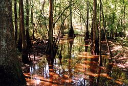
The Tickfaw River /ˈtɪkfɔː/ runs 113 miles (182 km)[1] from Amite County in southwest Mississippi to Livingston Parish in southeast Louisiana. Its mouth opens into Lake Maurepas, which conjoins with Lake Pontchartrain.[2]
The name Tickfaw (Tiak foha) is thought to be derived from the Choctaw phrase meaning "pine rest" or "Rest Among the Pines". [3][4] Alternate/historical names and spellings:[5]
- Rio De San Vicente
- Rio De Tickfaw
- Rio Go Tickfoha
- Riviere Ticfoha
- Ticfaw River
- Tickfah River
- Tickfaw Creek
See also
- List of rivers of Louisiana
- List of rivers of Mississippi
References
^ U.S. Geological Survey. National Hydrography Dataset high-resolution flowline data. The National Map, accessed June 20, 2011
^ The Columbia Gazetteer of North America. 2000.
^ Sandy Nestor (24 May 2012). Indian Placenames in America. McFarland. p. 1. ISBN 978-0-7864-9339-5..mw-parser-output cite.citation{font-style:inherit}.mw-parser-output .citation q{quotes:"""""""'""'"}.mw-parser-output .citation .cs1-lock-free a{background:url("//upload.wikimedia.org/wikipedia/commons/thumb/6/65/Lock-green.svg/9px-Lock-green.svg.png")no-repeat;background-position:right .1em center}.mw-parser-output .citation .cs1-lock-limited a,.mw-parser-output .citation .cs1-lock-registration a{background:url("//upload.wikimedia.org/wikipedia/commons/thumb/d/d6/Lock-gray-alt-2.svg/9px-Lock-gray-alt-2.svg.png")no-repeat;background-position:right .1em center}.mw-parser-output .citation .cs1-lock-subscription a{background:url("//upload.wikimedia.org/wikipedia/commons/thumb/a/aa/Lock-red-alt-2.svg/9px-Lock-red-alt-2.svg.png")no-repeat;background-position:right .1em center}.mw-parser-output .cs1-subscription,.mw-parser-output .cs1-registration{color:#555}.mw-parser-output .cs1-subscription span,.mw-parser-output .cs1-registration span{border-bottom:1px dotted;cursor:help}.mw-parser-output .cs1-ws-icon a{background:url("//upload.wikimedia.org/wikipedia/commons/thumb/4/4c/Wikisource-logo.svg/12px-Wikisource-logo.svg.png")no-repeat;background-position:right .1em center}.mw-parser-output code.cs1-code{color:inherit;background:inherit;border:inherit;padding:inherit}.mw-parser-output .cs1-hidden-error{display:none;font-size:100%}.mw-parser-output .cs1-visible-error{font-size:100%}.mw-parser-output .cs1-maint{display:none;color:#33aa33;margin-left:0.3em}.mw-parser-output .cs1-subscription,.mw-parser-output .cs1-registration,.mw-parser-output .cs1-format{font-size:95%}.mw-parser-output .cs1-kern-left,.mw-parser-output .cs1-kern-wl-left{padding-left:0.2em}.mw-parser-output .cs1-kern-right,.mw-parser-output .cs1-kern-wl-right{padding-right:0.2em}
^ William A. Read (30 October 1984). Indian Place Names in Alabama. University of Alabama Press. p. 68. ISBN 978-0-8173-0231-3.
^ USGS Geographic Names Information System - Tickfaw River
External links
- USGS Geographic Names Information System - West Branch Tickfaw River
- US EPA National Assessment Database
- Army Corps of Engineers Map of the Tickfaw River
- US Army Corps of Engineers River and Harbor Act Projects - New Orleans District
This article related to a river in Louisiana is a stub. You can help Wikipedia by expanding it. |
This article related to a river in Mississippi is a stub. You can help Wikipedia by expanding it. |


