Keszthely
Keszthely Mogentiana (in ancient Latin) Castellum (in medieval Latin) Kesthell (in German) Blatenski Kostel (in Slovene) | ||
|---|---|---|
| Town | ||
 | ||
| ||
 Keszthely Location of Keszthely | ||
| Coordinates: 46°46′11″N 17°14′53″E / 46.76965°N 17.24813°E / 46.76965; 17.24813Coordinates: 46°46′11″N 17°14′53″E / 46.76965°N 17.24813°E / 46.76965; 17.24813 | ||
| Country | ||
| Region | Western Transdanubia | |
| County | Zala | |
| District | Keszthely | |
| Government | ||
| • Mayor | Ferenc Ruzsics (Fidesz-KDNP) | |
| Area | ||
| • Total | 75.98 km2 (29.34 sq mi) | |
| Population (2017) | ||
| • Total | 19,652 | |
| • Density | 258.65/km2 (669.9/sq mi) | |
| Demonym(s) | keszthelyi | |
Population by ethnicity[1] | ||
| • Hungarians | 83.6% | |
| • Germans | 2.1% | |
| • Gypsies | 0.6% | |
| • Croats | 0.2% | |
| • Poles | 0.1% | |
| • Slovaks | 0.1% | |
| • Romanians | 0.1% | |
| • Ukranians | 0.1% | |
| • Others | 0.7% | |
Population by religion[2] | ||
| • Roman Catholic | 54.5% | |
| • Greek Catholic | 0.2% | |
| • Calvinists | 3.2% | |
| • Lutherans | 1.6% | |
| • Jews | 0.1% | |
| • Other | 1.2% | |
| • Non-religious | 11.6% | |
| • Unknown | 27.6% | |
| Time zone | UTC+1 (CET) | |
| • Summer (DST) | UTC+2 (CEST) | |
| Postal code | 8360 | |
| Area code | (+36) 83 | |
| Motorways | M76 Motorway (planned) | |
| NUTS 3 code | HU223 | |
| Distance from Budapest | 187 km (116 mi) Southwest | |
| International airports | Hévíz–Balaton Airport (SOB) previously Sármellék International Airport | |
| MP | Jenő Manninger (Fidesz) | |
| Website | www.keszthely.hu | |

Keszthely (Hungarian pronunciation: [ˈkɛsthɛj]; Slovene: Blatenski Kostel; German: Kesthell) is a Hungarian city of 20,895 inhabitants located on the western shore of Lake Balaton. It is the largest city by the lake and one of the more important cultural, educational and economic hubs in the region. Due to its favorable location and accessibility by both road and rail, Keszthely and the surrounding area is a preferred holiday destination.
Though settled since at least Roman times (the Keszthely culture of Romance pannonian language), the first historical evidence of the town Keszthely dates from a 1247 document. Since 1421, Keszthely has been a market town.
The Faculty for Agriculture of University of Pannonia is located in Keszthely. George Fejer, Hungarian author and librarian at the University of Pest, was born in Keszthely in 1766.
Contents
1 Etymology
2 Location
3 Museum
4 Climate
5 International relations
5.1 Twin towns — sister cities
6 Image gallery
7 See also
8 References
9 External links
Etymology
The name comes from Slavic *Kostel, see also the etymology of Kesztölc.[3][4]Hungarian hely: a site, a location. The Hungarian part of the name could be potentially formed by a phonetic similarity and folk etymology Kesztely→Keszthely.[3] 1247 Kesztel.[4]
Location
The city of Keszthely is located at the northwest corner of Lake Balaton, on the shore of one of the biggest lakes in Central Europe. The city is surrounded by forests and rolling hills to the north, plains to the south east and the lake. South from the city lies Kis-Balaton (Little Balaton), a swamp which is a part of the Zala river delta and which acts as a natural water purifier for Lake Balaton. The swamp is particularly known as a water fowl habitat and enjoys international recognition and protection as a natural reserve.

The city also enjoys the proximity of Hévíz, a town famous for its spa and health services. Keszthely is very close to some northern Balaton wine regions which are known to produce high quality white wines from locally cultivated varieties.
Keszthely is easily and rather quickly accessible by car from both Budapest, the capital of Hungary, and Vienna, the capital of Austria. Direct bus services between Keszthely and Budapest run several times a day.
Museum
Balaton Museum
The Balaton Museum Association was established in 1898 for among all Sandor Lovassy`s initiation. The starting of the museum building in Keszthely was in 1925 with the help of count Taszilo Festetics, on the basis of Györgyi Denes`s design in Neo-baroque style. With the building of the first museum in Zala county, the stones from pulled down stables next to Festetics Mannsion were used as well.
The collection shows the archeological, ethnographical, historical and natural scientific values of the Balaton area.
Climate
| Climate data for Keszthely | |||||||||||||
|---|---|---|---|---|---|---|---|---|---|---|---|---|---|
| Month | Jan | Feb | Mar | Apr | May | Jun | Jul | Aug | Sep | Oct | Nov | Dec | Year |
| Average high °C (°F) | −1 (31) | 2 (36) | 9 (49) | 16 (60) | 20 (68) | 25 (77) | 28 (83) | 27 (81) | 23 (73) | 17 (63) | 8 (46) | 2 (36) | 15 (59) |
| Average low °C (°F) | −5 (23) | −6 (22) | 2 (35) | 7 (45) | 10 (50) | 15 (59) | 16 (61) | 16 (60) | 12 (54) | 9 (48) | 1 (34) | −2 (29) | 6 (43) |
| Average precipitation mm (inches) | 56 (2.2) | 13 (0.5) | 23 (0.9) | 48 (1.9) | 79 (3.1) | 84 (3.3) | 43 (1.7) | 30 (1.2) | 58 (2.3) | 23 (0.9) | 15 (0.6) | 23 (0.9) | 493 (19.4) |
| Source: Weatherbase[5] | |||||||||||||
International relations
Twin towns — sister cities
Keszthely is twinned with:
 Levoča, Slovakia
 Stary Sącz, Poland
Łańcut, Poland[6]
Piwniczna, Poland
Jędrzejów, Poland
 Piran, Slovenia
 Boppard, Germany
 Hof van Twente, Netherlands
 Litomyšl, Czech Republic
Turnov, Czech Republic
 Alanya, Turkey
Image gallery
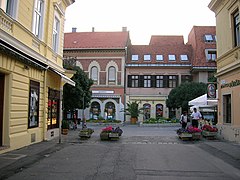
Keszthely town centre

Festetics Palace

Aerial photograph of the palace

Front view of the palace from the garden fountain
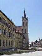
Our Lady of Hungary church (Magyarok Nagyasszonya templom)


See also
- Keszthely Synagogue
References
^ KSH - Keszthely, 2011
^ KSH - Keszthely, 2011
^ ab Stanislav, Ján (2004). Slovenský juh v stredoveku II (in Slovak). Slovenské literárne centrum. p. 231. ISBN 80-88878-89-6..mw-parser-output cite.citation{font-style:inherit}.mw-parser-output q{quotes:"""""""'""'"}.mw-parser-output code.cs1-code{color:inherit;background:inherit;border:inherit;padding:inherit}.mw-parser-output .cs1-lock-free a{background:url("//upload.wikimedia.org/wikipedia/commons/thumb/6/65/Lock-green.svg/9px-Lock-green.svg.png")no-repeat;background-position:right .1em center}.mw-parser-output .cs1-lock-limited a,.mw-parser-output .cs1-lock-registration a{background:url("//upload.wikimedia.org/wikipedia/commons/thumb/d/d6/Lock-gray-alt-2.svg/9px-Lock-gray-alt-2.svg.png")no-repeat;background-position:right .1em center}.mw-parser-output .cs1-lock-subscription a{background:url("//upload.wikimedia.org/wikipedia/commons/thumb/a/aa/Lock-red-alt-2.svg/9px-Lock-red-alt-2.svg.png")no-repeat;background-position:right .1em center}.mw-parser-output .cs1-subscription,.mw-parser-output .cs1-registration{color:#555}.mw-parser-output .cs1-subscription span,.mw-parser-output .cs1-registration span{border-bottom:1px dotted;cursor:help}.mw-parser-output .cs1-hidden-error{display:none;font-size:100%}.mw-parser-output .cs1-visible-error{font-size:100%}.mw-parser-output .cs1-subscription,.mw-parser-output .cs1-registration,.mw-parser-output .cs1-format{font-size:95%}.mw-parser-output .cs1-kern-left,.mw-parser-output .cs1-kern-wl-left{padding-left:0.2em}.mw-parser-output .cs1-kern-right,.mw-parser-output .cs1-kern-wl-right{padding-right:0.2em}
^ ab Kiss, Lajos (1978). Földrajzi nevek etimológiai szótára (in Hungarian). Budapest: Akadémiai. p. 331.
^
"Weatherbase: Historical Weather for Keszthely, Hungary". Weatherbase. 2011.
Retrieved on November 24, 2011.
^ "Łańcut Official Website - Foreign contacts". (in English) © 2008 Urząd Miejski w Łańcucie, Plac Sobieskiego 18, 37-100 Łańcut. Retrieved 2008-11-20.
External links
| Wikimedia Commons has media related to Keszthely. |
| Wikivoyage has a travel guide for Keszthely. |
Official website in Hungarian, English, German and Russian
Keszthely at Veszprém University (in English)
- Aerial photography: Keszthely
- Keszthely in Flickr
Keszthely at funiq.hu (in English)
- http://west-balaton.hu/en/keszthely/keszthely-muzeumok/balatoni-muzeum
Keszthely's neighbours | ||||||||||
|---|---|---|---|---|---|---|---|---|---|---|
| ||||||||||
Towns and villages of Keszthely District | ||
|---|---|---|
| Towns (2) |
| |
| Large villages (2) |
| |
| Villages (26) |
| |
Zala County | ||
|---|---|---|
| Cities with county rights |
|   |
| Towns |
| |
| Large villages |
| |
| Villages |
| |
| Other topics |
| |


