Veszprém County
This article may be expanded with text translated from the corresponding article in Hungarian. (December 2012) Click [show] for important translation instructions.
|
Veszprém County Veszprém megye | |||
|---|---|---|---|
| Counties of Hungary | |||
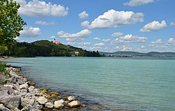 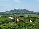  Descending, from top: View of Tihany Abbey from Lake Balaton, Badacsony Mountain, and Castle of Veszprém | |||
| |||
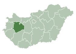 Veszprém County within Hungary | |||
| Country | |||
| Region | Central Transdanubia | ||
| County seat | Veszprém | ||
| Districts | 10 districts
| ||
| Government | |||
| • President of the General Assembly | Imre Polgárdy (Fidesz-KDNP) | ||
| Area | |||
| • Total | 4,463.65 km2 (1,723.42 sq mi) | ||
| Area rank | 9th in Hungary | ||
| Population (2015) | |||
| • Total | 346,647[1] | ||
| • Rank | 12th in Hungary | ||
| Postal code | 810x, 816x – 819x, 830x – 8352, 84xx – 85xx | ||
| Area code(s) | (+36) 87, 88, 89 | ||
| ISO 3166 code | .mw-parser-output .monospaced{font-family:monospace,monospace} HU-VE | ||
| Website | www.vpmegye.hu | ||

Veszprém (Hungarian: Veszprém megye, pronounced [ˈvɛspreːm]; German: Komitat Wesprim (Weißbrunn)) is an administrative county (megye) in Hungary. Veszprém is also the name of the capital city of Veszprém county.
Contents
1 Veszprém county
2 History
3 Demographics
3.1 Ethnicity
3.2 Religion
4 Regional structure
5 Politics
5.1 Presidents of the General Assembly
6 Municipalities
7 Gallery
8 References
9 External links
Veszprém county
Veszprém county lies in western Hungary. It covers the Bakony hills and the northern shore of Lake Balaton. It shares borders with the Hungarian counties Vas, Győr-Moson-Sopron, Komárom-Esztergom, Fejér, Somogy and Zala. The capital of Veszprém county is Veszprém. The river Marcal runs along part of its western border. Its area is 4613 km².

Veszprém County on an old map
History
Demographics
Religion in Veszprém County (2011 census)
Catholic Church (47.2%)
Greek Catholicism (0.2%)
Calvinism (8.6%)
Lutheranism (3.6%)
Other religions (1.3%)
Non-religious (12.2%)
Atheists (1.1%)
Undeclared (25.8%)
In 2015, it had a population of 346,647 and the population density was 77/km².
| Year | County population[2] | Change |
|---|---|---|
| 1949 | 294,289 | n/a |
| 1960 | 14.80% | |
| 1970 | 5.92% | |
| 1980 | 5.57% | |
| 1990 | -0.87% | |
| 2001 | -1.27% | |
| 2011 | -4.51% |
Ethnicity
Besides the Hungarian majority, the main minorities are the Germans (approx. 8,500) and Roma (5,000).
Total population (2011 census): 353,068
Ethnic groups (2011 census):[3]
Identified themselves: 315 436 persons:
Hungarians: 299 410 (94,92%)
Germans: 8 473 (2,69%)
Gypsies: 5 162 (1,64%)- Others and indefinable: 2 391 (0,76%)
Approx. 51,000 persons in Veszprém County did not declare their ethnic group at the 2011 census.
Religion
Religious adherence in the county according to 2011 census:[4]
- Catholic – 167,372 (Roman Catholic – 166,597; Greek Catholic – 719);
Reformed – 30,491;
Evangelical – 12,813;- other religions – 4,376;
Non-religious – 43,171;
Atheism – 3,915;
Undeclared – 90,930.
Regional structure

District of Veszprém County
| № | English and Hungarian names | Area (km²) | Population (2011) | Density (pop./km²) | Seat | № of municipalities |
| 1 | Ajka District Ajkai járás | 320.71 | 39,160 | 122 | Ajka | 11 |
| 2 | Balatonalmádi District Balatonalmádi járás | 239.75 | 24,330 | 101 | Balatonalmádi | 10 |
| 3 | Balatonfüred District Balatonfüredi járás | 357.75 | 23,849 | 67 | Balatonfüred | 22 |
| 4 | Devecser District Devecseri járás | 421.73 | 15,079 | 36 | Devecser | 28 |
| 5 | Pápa District Pápai járás | 1,022.09 | 59,310 | 58 | Pápa | 49 |
| 6 | Sümeg District Sümegi járás | 306.48 | 15,358 | 50 | Sümeg | 21 |
| 7 | Tapolca District Tapolcai járás | 540.30 | 34,256 | 63 | Tapolca | 33 |
| 8 | Várpalota District Várpalotai járás | 294.28 | 37,882 | 129 | Várpalota | 8 |
| 9 | Veszprém District Veszprémi járás | 629.61 | 83,288 | 132 | Veszprém (town) | 19 |
| 10 | Zirc District Zirci járás | 331.02 | 19,386 | 59 | Zirc | 15 |
| Veszprém County | 4,463.65 | 353,068 | 78 | Veszprém | 217 | |
|---|---|---|---|---|---|---|
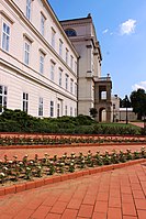
Politics

Countyhall of Veszprém.
The Veszprém County Council, elected at the 2014 local government elections, is made up of 17 counselors, with the following party composition:[5]
| | Party | Seats | Current County Assembly | |||||||||
|---|---|---|---|---|---|---|---|---|---|---|---|---|
| | Fidesz-KDNP | 10 | | | | | | | | | | |
| | Movement for a Better Hungary (Jobbik) | 3 | | | | | | | | | | |
| | Hungarian Socialist Party (MSZP) | 3 | | | | | | | | | | |
| | Democratic Coalition (DK) | 1 | | | | | | | | | | |
Presidents of the General Assembly
| List of Presidents, from 1990[6] | |
|---|---|
Imre Polgárdy (Fidesz-KDNP) | 2014– |
Municipalities
Veszprém County has 1 urban county, 14 towns, 2 large villages and 200 villages.
- City with county rights
(ordered by population, as of 2011 census)
Veszprém (61,721) – county seat
- Towns
Pápa (33,583)
Ajka (31,971)
Várpalota (21,682)
Tapolca (17,914)
Balatonfüred (13,289)
Balatonalmádi (8,514)
Zirc (7,445)
Sümeg (6,847)
Berhida (5,927)
Devecser (5,232)
Balatonfűzfő (4,337)
Herend (3,446)
Balatonkenese (3,311)
Badacsonytomaj (2,312)
- Villages
- Adásztevel
- Adorjánháza
- Alsóörs
- Apácatorna
- Aszófő
- Ábrahámhegy
- Badacsonytördemic
- Bakonybél
- Bakonyjákó
- Bakonykoppány
- Bakonynána
- Bakonyoszlop
- Bakonypölöske
- Bakonyság
- Bakonyszentiván
- Bakonyszentkirály
- Bakonyszücs
- Bakonytamási
- Balatonakali
- Balatonakarattya
- Balatoncsicsó
- Balatonederics
- Balatonfőkajár
- Balatonhenye
- Balatonrendes
- Balatonszepezd
- Balatonszőlős
- Balatonudvari
- Balatonvilágos
- Barnag
- Bazsi
- Bánd
- Béb
- Békás
- Bodorfa
- Borszörcsök
- Borzavár
- Csabrendek
- Csajág
- Csehbánya
- Csesznek
- Csetény
- Csögle
- Csopak
- Csót
- Dabronc
- Dabrony
- Dáka
- Doba
- Döbrönte
- Dörgicse
- Dudar
- Egeralja
- Egyházaskesző
- Eplény
- Farkasgyepű
- Felsőörs
- Ganna
- Gecse
- Gic
- Gógánfa
- Gyepükaján
- Gyulakeszi
- Hajmáskér
- Halimba
- Hárskút
- Hegyesd
- Hegymagas
- Hetyefő
- Hidegkút
- Homokbödöge
- Hosztót
- Iszkáz
- Jásd
- Kamond
- Kapolcs
- Karakószörcsök
- Káptalanfa
- Káptalantóti
- Kemeneshőgyész
- Kemenesszentpéter
- Kerta
- Kékkút
- Királyszentistván
- Kisapáti
- Kisberzseny
- Kiscsősz
- Kislőd
- Kispirit
- Kisszőlős
- Kolontár
- Köveskál
- Kővágóörs
- Kup
- Külsővat
- Küngös
- Lesencefalu
- Lesenceistvánd
- Lesencetomaj
- Litér
- Lovas
- Lovászpatona
- Lókút
- Magyargencs
- Magyarpolány
- Malomsok
- Marcalgergelyi
- Marcaltő
- Márkó
- Megyer
- Mencshely
- Mezőlak
- Mihályháza
- Mindszentkálla
- Monostorapáti
- Monoszló
- Nagyacsád
- Nagyalásony
- Nagydém
- Nagyesztergár
- Nagygyimót
- Nagypirit
- Nagytevel
- Nagyvázsony
- Nemesgörzsöny
- Nemesgulács
- Nemeshany
- Nemesszalók
- Nemesvámos
- Nemesvita
- Németbánya
- Noszlop
- Nóráp
- Nyárád
- Nyirád
- Olaszfalu
- Oroszi
- Óbudavár
- Öcs
- Örvényes
- Öskü
- Ősi
- Paloznak
- Papkeszi
- Pápadereske
- Pápakovácsi
- Pápasalamon
- Pápateszér
- Pécsely
- Pénzesgyőr
Pétfürdő
- Porva
- Pula
- Pusztamiske
- Raposka
Révfülöp
- Rigács
- Salföld
- Sáska
- Somlójenő
- Somlószőlős
- Somlóvásárhely
- Somlóvecse
- Sóly
- Sümegprága
- Szápár
- Szentantalfa
- Szentbékkálla
- Szentgál
- Szentimrefalva
- Szentjakabfa
- Szentkirályszabadja
- Szigliget
- Szőc
- Tagyon
- Takácsi
- Taliándörögd
- Tapolca-Diszel
- Tés
- Tihany
- Tótvázsony
- Tüskevár
- Ugod
- Ukk
- Uzsa
- Úrkút
- Vanyola
- Varsány
- Vaszar
- Várkesző
- Városlőd
- Várpalota
- Vászoly
- Veszprémfajsz
- Veszprémgalsa
- Vid
- Vigántpetend
- Vilonya
- Vinár
- Vöröstó
- Zalaerdőd
- Zalagyömörő
- Zalahaláp
- Zalameggyes
- Zalaszegvár
- Zánka
![]() municipalities are large villages.
municipalities are large villages.
Gallery

Veszprém, the City of Queens

The Watermill of Tapolca

Tihany, behind Tihany Abbey and Lake Balaton
Cistercian Convent at Zirc

Badacsony

Castle of Vázsonykő, Nagyvázsony

Round church of Öskü
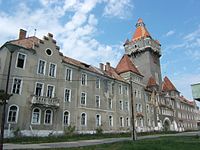
Former E1 headquarter building, Hajmáskér


References
| Wikimedia Commons has media related to Veszprém County. |
| Wikivoyage has a travel guide for Veszprém County. |
^ nepesseg.com, population data of Hungarian settlements
^ népesség.com, "Veszprém megye népessége 1870-2015"
^ 1.1.6. A népesség anyanyelv, nemzetiség és nemek szerint – Frissítve: 2013.04.17.; Hungarian Central Statistical Office (in Hungarian)
^ 2011. ÉVI NÉPSZÁMLÁLÁS, 3. Területi adatok, 3.19 Veszprém megye, (in Hungarian) [1]
^ A Közgyűlés, (in Hungarian) [2]
^ Önkormányzati választások eredményei (in Hungarian)
External links
Official site in Hungarian- Napló (veol.hu) - The county portal
Veszprém County | ||
|---|---|---|
| City with county rights |
|   |
| Towns |
| |
| Large villages |
| |
| Villages |
| |
| Other topics |
| |
Counties (megyék) of Hungary | ||
|---|---|---|
| ||
Coordinates: 47°10′N 17°45′E / 47.167°N 17.750°E / 47.167; 17.750
Authority control |
|
|---|


